Country Homes, Washington facts for kids
Quick facts for kids
Country Homes, Washington
|
|
|---|---|

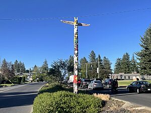
Totem Pole on Country Homes Boulevard
|
|

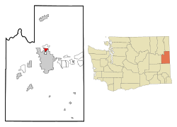
Location of Country Homes, Washington
|
|
| Country | United States |
| State | Washington |
| County | Spokane |
| Area | |
| • Land | 1.67 sq mi (4.3 km2) |
| Elevation | 1,952 ft (595 m) |
| Population | |
| • Total | 6,251 |
| • Density | 3,743/sq mi (1,445/km2) |
| Time zone | UTC-8 (Pacific (PST)) |
| • Summer (DST) | UTC-7 (PDT) |
| FIPS code | 53-15150 |
| GNIS feature ID | 1512118 |
Country Homes is a special kind of community in Spokane County, Washington, called a census-designated place (CDP). This means it's like a town, but it's not officially governed by its own city government. In 2020, about 6,251 people lived here.
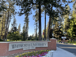
A big part of Country Homes is where Whitworth University is located. The area is mostly suburban, meaning it has lots of homes and neighborhoods. It's right next to the city of Spokane and other similar communities like Town and Country and Fairwood.
Contents
History of Country Homes
Long ago, the land where Country Homes is now was home to the Spokane people. They lived here for thousands of years, using the nearby Little Spokane River for their needs.
The first Europeans came to this area in 1810. They were fur traders who built a trading post called Spokane House. This post was a few miles northwest of where Country Homes is today.
A big change for Country Homes happened in 1914. That's when Whitworth University moved its campus here. It had started in another part of Washington in 1890.
Over the years, roads were built to connect Country Homes to Spokane. Division Street, a main road, was paved in 1932. Later, in 1965, Country Homes Boulevard was built. This road helped connect the growing neighborhoods of Country Homes to the main part of Spokane.
Even though Spokane city has grown and taken over areas nearby, Country Homes has stayed an independent community. It's still part of Spokane County but not officially part of the city of Spokane.
Exploring Country Homes Geography
Country Homes is a suburban area located north of Downtown Spokane, about five miles away. It's shaped a bit like a triangle.
The community's borders are:
- To the northwest, it's near Five Mile Road.
- To the northeast, it goes along the edge of the Whitworth University campus and up to U.S. Highway 2.
- To the east, U.S. Highway 2 and U.S. Highway 395 (also known as Division Street) form the boundary.
- To the west, the boundary follows a steep hill that leads up to the Five Mile Prairie neighborhood.
Country Homes is surrounded by other areas. It borders Spokane's Shiloh Hills neighborhood to the east. To the south is Town and Country, and to the north is Fairwood.
The land in Country Homes is mostly flat or gently slopes downwards towards the north. To the west, there's a steep hill called the Five Mile Prairie. The Little Spokane River flows about a mile north of Country Homes.
Country Homes is located at 47°44′44″N 117°25′3″W / 47.74556°N 117.41750°W. The total area of Country Homes is about 1.7 square miles, and it's all land.
People Living in Country Homes
| Historical population | |||
|---|---|---|---|
| Census | Pop. | %± | |
| 1990 | 5,126 | — | |
| 2000 | 5,203 | 1.5% | |
| 2010 | 5,841 | 12.3% | |
| 2020 | 6,251 | 7.0% | |
| U.S. Decennial Census | |||
In 2020, there were 6,251 people living in Country Homes. There were also 2,082 homes and 1,825 families. The area is quite populated, with about 3,677 people per square mile.
Most people living in Country Homes are White. There are also people from many other backgrounds, including African American, Native American, Asian, and Pacific Islander residents. About 5.79% of the population is Hispanic or Latino.
Getting Around Country Homes
Roads and Highways
Country Homes is connected by important roads that help people travel.
 - U.S. 2 goes north towards Newport and south towards Spokane.
 - U.S. 395 also runs north and south through Country Homes, known locally as Division Street.
Other important local roads include Country Homes Boulevard, Wall Street, and Hawthorne Road. These roads help people get around the community and connect to other parts of Spokane.
Public Buses
The Spokane Transit Authority (STA) provides bus services in Country Homes. This means you can use public buses to travel around the area.
| Route | Where it goes | How often it runs | Streets it travels | ||
|---|---|---|---|---|---|
|
25
Division |
Downtown Spokane STA Plaza |
↔ | Fairwood Hastings Park and Ride |
Runs often | Newport Highway, Hawthorne, Division |
|
28
Nevada |
Downtown Spokane STA Plaza |
↔ | Country Homes Whitworth University |
Runs regularly | Hawthorne, Whitworth Drive, Wall, Hawthorne |
|
124
North Express |
Downtown Spokane STA Plaza |
↔ | Fairwood Hastings Park and Ride |
Express route during busy weekday hours | Wall, Waikiki |
See also
 In Spanish: Country Homes (Washington) para niños
 | Victor J. Glover |
 | Yvonne Cagle |
 | Jeanette Epps |
 | Bernard A. Harris Jr. |


