Town and Country, Washington facts for kids
Quick facts for kids
Town and Country, Washington
|
|
|---|---|

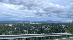
Town and Country from Five Mile Prairie looking southeast
|
|

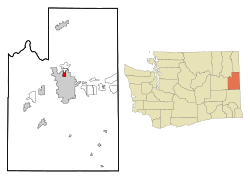
Location of Town and Country, Washington
|
|
| Country | United States |
| State | Washington |
| County | Spokane |
| Area | |
| • Total | 1.2 sq mi (3 km2) |
| • Land | 1.2 sq mi (3 km2) |
| • Water | 0.0 sq mi (0 km2) |
| Elevation | 2,060 ft (628 m) |
| Population
(2020)
|
|
| • Total | 5,068 |
| • Density | 4,223.3/sq mi (1,630.6/km2) |
| Time zone | UTC-8 (Pacific (PST)) |
| • Summer (DST) | UTC-7 (PDT) |
| FIPS code | 53-72170 |
| GNIS feature ID | 1867638 |
Town and Country is a small community in Spokane County, Washington, in the United States. It's often called 'Lynwood' by people who live there. In 2020, about 5,068 people lived in Town and Country. It's known as a census-designated place (CDP), which means it's a special area that the government counts for population, but it's not officially a city or town with its own local government.
Contents
Where is Town and Country?
Town and Country is located in the state of Washington. It covers about 1.2 square miles, and all of this area is land.
The big city of Spokane surrounds Town and Country on three sides: to the east, south, and west. The streets from Spokane continue right into Town and Country on the east side. However, on the west side, the land starts to go uphill towards a place called Five Mile Prairie.
Most of Town and Country is on flat ground, just like the northern part of Spokane. But on the west side, the land quickly rises from about 2,000 feet to over 2,300 feet. Town and Country also blends smoothly into its neighbor to the north, which is another community called Country Homes, Washington.
Borders and Roads
Several main roads form the borders of Town and Country:
- Francis Avenue is the southern border. It carries Washington State Route 291.
- Cedar Road is the western border. It goes up the hill towards Five Mile Prairie.
- Country Homes Boulevard forms most of the northern border with Country Homes.
- Division Street used to be the eastern border. It carries U.S. Route 2. In 2008, part of Town and Country became part of Spokane. Now, Division Street is still the eastern border for some sections.
Most of Town and Country is for homes, with houses close together. But there are also shopping areas along Francis Avenue and Division Street.
Who Lives in Town and Country?
In 2020, there were 5,068 people living in Town and Country. There were 2,109 households, which means about 2.56 people lived in each home. On average, there were 4,223.3 people living in every square mile.
Most of the people living here, about 89.2%, are White. Other groups include 1.3% African American, 1.3% Asian, and 0.1% Native American. About 7.4% of the people are from two or more races. People who are Hispanic or Latino make up 6.9% of the population.
About 25.2% of the people are under 18 years old. About 16.1% are 65 years old or older. Slightly more than half of the population, 51.4%, are female. About 66.7% of people aged 16 and older have jobs.
Schools in Town and Country
Town and Country is divided between two different school districts.
- The southern part of the community is served by Spokane Public Schools.
- Linwood Elementary School is located here. After elementary school, students go to Salk Middle School and then to Shadle Park High School.
- The northern part is served by the Mead School District.
- Evergreen Elementary School is also in Town and Country. Students from Evergreen go to Highland Middle School and then to Mead High School.
Getting Around Town and Country
Main Roads
Several important highways pass through or along the edges of Town and Country:
 U.S. Route 2 runs north and south along Division Street, on the eastern side of Town and Country. It connects to Newport to the north and Spokane to the south.
 U.S. Route 395 also runs north and south along Division Street. It goes to Colville in the north and Spokane in the south.
 State Route 291 runs along Francis Avenue, which is the southern border of Town and Country. It connects to Tumtum to the north and Spokane to the south.
These highways are regular streets, not special highways where you can't stop. Francis Avenue and Division Street are considered very important roads by the city of Spokane. Country Homes Boulevard is also a major road, especially for connecting different parts of the area. In 2018, about 26,400 vehicles used Country Homes Boulevard every day, making it one of the busiest roads in this part of Spokane County.
For people who like to bike, there are special bike lanes on Wall Street, Country Homes Boulevard, and Lincoln Road. Cedar Road is also a good road for sharing with bikes.
Public Transportation
The Spokane Transit Authority (STA) provides bus services in Town and Country. There are four different bus routes that go through the community. There are also two "Park & Ride" locations nearby, where people can park their cars and take the bus: the Country Homes Park & Ride and the Five Mile Park & Ride.
| Route | Where it Goes | How Often it Runs | Streets it Travels | ||
|---|---|---|---|---|---|
|
4
Monroe |
Downtown Spokane STA Plaza |
↔ | Balboa/South Indian Trail Five Mile Park and Ride |
Runs very often | Francis Avenue west of Monroe |
|
25
Division |
Downtown Spokane STA Plaza |
↔ | Fairwood Hastings Park and Ride |
Runs very often | Division Street |
|
27
Hillyard |
Downtown Spokane STA Plaza |
↔ | Balboa/South Indian Trail Five Mile Park and Ride |
Runs regularly; goes through Hillyard | Francis Avenue |
|
124
North Express |
Downtown Spokane STA Plaza |
↔ | Fairwood Hastings Park and Ride |
Runs quickly during busy weekday hours | Monroe Street |
See also
 In Spanish: Town and Country (Washington) para niños
 | Calvin Brent |
 | Walter T. Bailey |
 | Martha Cassell Thompson |
 | Alberta Jeannette Cassell |


