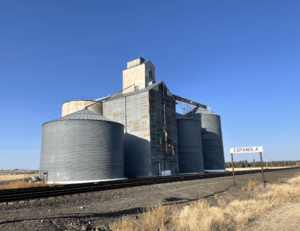
Espanola, Washington facts for kids
Quick facts for kids
Espanola, Washington
|
|
|---|---|
 |
|
| Country | United States |
| State | Washington |
| County | Spokane |
| Elevation | 2,385 ft (727 m) |
| Population | |
| • Total | 20 |
| Time zone | UTC-8 (Pacific (PST)) |
| • Summer (DST) | UTC-7 (PDT) |
| ZIP code |
99022
|
| Area code(s) | 509 |
| GNIS feature ID | 1510948 |
| Census Code | 22220 |
| Census Class Code | U6 |
| GSA Code | 0684 |
Espanola is a small, unincorporated community located in Spokane County, Washington, in the United States. An unincorporated community means it's a group of homes or businesses that isn't part of an official city or town. The name Espanola was chosen in the year 1900. As of 2021, Espanola is mostly a few buildings and a large grain elevator, surrounded by many farms.
Contents
Exploring Espanola's Past
Espanola was once the name of one of the 47 townships in Spokane County. Townships are like smaller areas within a county. This was true from the early 1900s through the middle of the century.
In 1960, a group of people called Hutterites moved to the Espanola area. The Hutterites are a community known for living together and farming. While they faced some challenges with the local residents at first, their community is still active nearby. As of 2006, they are located a few miles north of Espanola, closer to the community of Deep Creek.
Discovering Espanola's Location
Espanola is about 18 miles west-southwest of Downtown Spokane. It is also just three miles east of the border between Spokane County and Lincoln County.
The land around Espanola is mostly flat or gently rolling farmland. There are not many trees. This area is part of the Channeled Scablands on the Columbia Plateau.
Nearby Communities and Landmarks
- Medical Lake: This is the closest community to Espanola, about four miles southeast. It offers the nearest services.
- Washington State Veterans Cemetery: This important cemetery is located between Espanola and Medical Lake.
- Deep Creek: This community is about four miles north of Espanola.
- Fairchild Air Force Base: A large Air Force base is located just two miles east of Espanola.
Transportation Routes
A BNSF Railway track, called the Columbia River Subdivision, runs right through Espanola. This means trains pass by the community.
For roads, Manila Road goes through Espanola. Espanola Road connects the community to other areas. You can reach Espanola Road from U.S. Route 2 (about three miles north) or from State Route 902 in Medical Lake.
Espanola's Population Over Time
| Historical population | |||
|---|---|---|---|
| Census | Pop. | %± | |
| 1910 | 399 | — | |
| 1920 | 318 | −20.3% | |
| 1930 | 1,740 | 447.2% | |
| 1940 | 2,332 | 34.0% | |
| 1950 | 195 | −91.6% | |
| 2015 (est.) | 20 | ||
| U.S. Census | |||
 | William M. Jackson |
 | Juan E. Gilbert |
 | Neil deGrasse Tyson |


