Peone, Washington facts for kids
Quick facts for kids
Peone, Washington
|
|
|---|---|

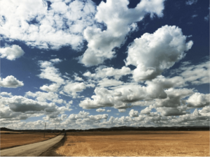
Peone Prairie from Peone Road
|
|
| Country | United States |
| State | Washington |
| County | Spokane |
| Time zone | UTC-8 (Pacific (PST)) |
| • Summer (DST) | UTC-7 (PDT) |
| ZIP code |
99021
|
| Area code(s) | 509 |
| GNIS feature ID | 1511223 |
Peone is a small, quiet place in Spokane County, which is part of Washington State in the United States. It's called an unincorporated community, meaning it doesn't have its own city government like a town or city would.
Contents
Where is Peone Located?
Peone is found on the Peone Prairie. This is a special spot where wide, open farmland meets the hills of Mount Spokane. A stream called Deadman Creek flows from the mountains right into the prairie near Peone.
Roads and Nearby Places
A road called Washington State Route 206 goes right through Peone. If you travel west on this road, you'll reach Mead, Washington. If you go east, you'll head up towards Mount Spokane State Park.
The Peone Prairie stretches out to the southwest. It's mostly farmland with houses spread far apart. Peone is about a 30-minute drive from Downtown Spokane, which is 16 miles to the southwest. Another community called Green Bluff, Washington is north of Peone, located at a higher elevation.
A Glimpse into Peone's Past
Peone got its name from a Native American tribal chief. A post office was opened here in 1883. It served the community for many years before closing in 1933.
How Peone is Changing
Because Peone is close to Spokane and its growing suburbs, the area has been changing. It used to be a very rural place, meaning it was mostly farms and open land. But in recent years, more homes have been built. This has given Peone a more "exurban" feel, which means it's becoming a mix of country and suburban living.
 | Janet Taylor Pickett |
 | Synthia Saint James |
 | Howardena Pindell |
 | Faith Ringgold |


