Airway Heights, Washington facts for kids
Quick facts for kids
Airway Heights, Washington
|
||
|---|---|---|

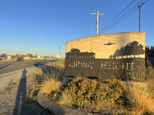
Welcome to Airway Heights sign on U.S. Route 2
|
||
|
||

Location of Airway Heights, Washington
|
||
| Country | United States | |
| State | Washington | |
| County | Spokane | |
| Government | ||
| • Type | Council–manager | |
| Area | ||
| • Total | 6.01 sq mi (15.57 km2) | |
| • Land | 6.01 sq mi (15.57 km2) | |
| • Water | 0.00 sq mi (0.00 km2) | |
| Elevation | 2,398 ft (731 m) | |
| Population
(2020)
|
||
| • Total | 10,757 | |
| • Density | 1,789.9/sq mi (691.1/km2) | |
| Time zone | UTC−8 (Pacific (PST)) | |
| • Summer (DST) | UTC−7 (PDT) | |
| ZIP code |
99001
|
|
| Area code | 509 | |
| FIPS code | 53-00905 | |
| GNIS feature ID | 1511953 | |
Airway Heights is a city in Spokane County, Washington, United States. It is located just west of the larger city of Spokane. Airway Heights is part of the Spokane metropolitan area, which means it's connected to the bigger city. In 2020, about 10,757 people lived there. The city's name comes from its location very close to the runways of Fairchild Air Force Base and Spokane International Airport.
Contents
History of Airway Heights
Airway Heights was founded in 1942. It officially became a city on June 28, 1955.
How Airway Heights Grew
The city started to grow a lot after a few important places opened. The Airway Heights Corrections Center opened in 1992. Then, the Northern Quest Resort & Casino opened in 2000. This casino was built by the Kalispel Indian Tribe.
In the years since, Airway Heights has seen many changes. New stores and shops have opened. Many new apartment buildings and housing areas were built. The Northern Quest Casino also got bigger. Another casino, the Spokane Tribe Casino, also opened in the city.
Geography of Airway Heights
Airway Heights is located at 47°38′37″N 117°35′11″W / 47.64361°N 117.58639°W. Downtown Spokane is about eight miles east of Airway Heights by road. In 2012, the city of Spokane included the Spokane International Airport area. After that, Spokane became a neighbor to Airway Heights on its east and south sides.
Land Area
According to the United States Census Bureau, the city covers a total area of about 5.63 square miles (14.58 square kilometers). All of this area is land.
Elevation and Landscape
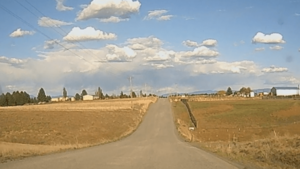
The community is in the northeastern part of the flat Columbia Plateau. Even though the plateau is generally flat, the land right around Airway Heights is quite rugged. This is because it's part of an area called the Channeled Scablands. The "heights" in the city's name means it's higher up than the center of Spokane. If you travel into Airway Heights from Downtown Spokane on U.S. Route 2, which is the main road, you will climb over 500 feet.
Climate in Airway Heights
| Climate data for Airway Heights, Washington (Spokane Int'l), 1981–2010 normals | |||||||||||||
|---|---|---|---|---|---|---|---|---|---|---|---|---|---|
| Month | Jan | Feb | Mar | Apr | May | Jun | Jul | Aug | Sep | Oct | Nov | Dec | Year |
| Record high °F (°C) | 62 (17) |
63 (17) |
74 (23) |
90 (32) |
97 (36) |
105 (41) |
108 (42) |
108 (42) |
98 (37) |
87 (31) |
70 (21) |
60 (16) |
108 (42) |
| Mean daily maximum °F (°C) | 34.4 (1.3) |
39.6 (4.2) |
48.9 (9.4) |
57.2 (14.0) |
66.4 (19.1) |
73.8 (23.2) |
83 (28.3) |
83 (28.3) |
72.9 (22.7) |
58.0 (14.4) |
41.6 (5.3) |
32.2 (0.1) |
57.6 (14.2) |
| Daily mean °F (°C) | 29.55 (−1.36) |
33 (1) |
40.25 (4.58) |
47 (8) |
55.1 (12.8) |
62.1 (16.7) |
69.65 (20.92) |
69.4 (20.8) |
60.3 (15.7) |
47.6 (8.7) |
35.7 (2.1) |
27.35 (−2.58) |
48.08 (8.95) |
| Mean daily minimum °F (°C) | 24.7 (−4.1) |
26.4 (−3.1) |
31.6 (−0.2) |
36.8 (2.7) |
43.8 (6.6) |
50.4 (10.2) |
56.3 (13.5) |
55.8 (13.2) |
47.4 (8.6) |
37.2 (2.9) |
29.8 (−1.2) |
22.5 (−5.3) |
38.6 (3.7) |
| Record low °F (°C) | −30 (−34) |
−24 (−31) |
−10 (−23) |
14 (−10) |
24 (−4) |
33 (1) |
37 (3) |
35 (2) |
22 (−6) |
7 (−14) |
−21 (−29) |
−25 (−32) |
−30 (−34) |
| Average precipitation inches (mm) | 1.79 (45) |
1.33 (34) |
1.61 (41) |
1.28 (33) |
1.62 (41) |
1.25 (32) |
0.64 (16) |
0.59 (15) |
0.67 (17) |
1.18 (30) |
2.30 (58) |
2.29 (58) |
16.55 (420) |
| Average snowfall inches (cm) | 12.0 (30) |
7.2 (18) |
3.7 (9.4) |
1.0 (2.5) |
0.1 (0.25) |
0 (0) |
0 (0) |
0 (0) |
0 (0) |
0.1 (0.25) |
7.2 (18) |
14.9 (38) |
46.2 (117) |
| Average precipitation days (≥ 0.01 in) | 13.4 | 10.4 | 11.6 | 10.1 | 10.2 | 7.9 | 5.0 | 3.8 | 5.1 | 7.8 | 13.7 | 13.2 | 112.2 |
| Average snowy days (≥ 0.1 in) | 8.9 | 5.1 | 4.1 | 1.1 | 0.3 | 0 | 0 | 0 | 0 | 0.2 | 4.7 | 9.8 | 34.2 |
| Average relative humidity (%) | 62.0 | 81.5 | 75.0 | 66.5 | 60.5 | 58.0 | 50.5 | 45.5 | 49.0 | 57.0 | 68.0 | 81.5 | 80.5 |
| Percent possible sunshine | 28 | 41 | 55 | 61 | 65 | 67 | 80 | 78 | 72 | 55 | 29 | 23 | 55 |
| Source: NOAA (extremes 1881–present, percent sunshine through 2009) | |||||||||||||
Airway Heights has a climate with warm summers and cold winters. The weather box above shows detailed information about the temperatures and precipitation throughout the year.
Population and People
| Historical population | |||
|---|---|---|---|
| Census | Pop. | %± | |
| 1960 | 708 | — | |
| 1970 | 744 | 5.1% | |
| 1980 | 1,730 | 132.5% | |
| 1990 | 1,971 | 13.9% | |
| 2000 | 4,500 | 128.3% | |
| 2010 | 6,114 | 35.9% | |
| 2020 | 10,757 | 75.9% | |
| U.S. Decennial Census | |||
The population of Airway Heights has grown quite a lot over the years.
2020 Census Information
In the 2020 United States Census, there were 10,757 people living in Airway Heights. These people lived in 2,371 households.
2010 Census Information
During the 2010 United States Census, the city had 6,114 people. They lived in 1,547 households. About 1,035 of these were families. The city had about 1,086 people per square mile.
Education in Airway Heights
Most of Airway Heights is part of the Cheney School District (No. 360). A smaller part in the northeast belongs to the Great Northern School District (No. 312), which serves students from kindergarten to 6th grade.
In 2023, Airway Heights joined the Spokane County Library District. This happened after the city's residents voted for it. The city already had an agreement with the library district to run a library branch in Airway Heights.
Healthcare Services
The closest hospital to Airway Heights is Deaconess Medical Center. It is located in Downtown Spokane. Within Airway Heights itself, you can find several healthcare services. These include the Airway Heights Dental Center, West Plains Chiropractor, and APEX Physical Therapy.
Transportation Around the City
U.S. Route 2 is the main road that goes east and west through the city. Airway Heights does not have a traditional downtown area. There are plans to build a new street. This street will help connect local areas and offer another way to get around besides the main highway. U.S. Route 2 connects Airway Heights to Fairchild in the west and Spokane in the east. Interstate 90 is a major highway that runs just a few miles south of the city.
Public Transport
Public transportation in Airway Heights is managed by the Spokane Transit Authority. Bus route 61 serves Airway Heights. This bus route starts at the main transit hub in Downtown Spokane. It then extends all the way to Fairchild Air Force Base.
Fun and Recreation
Spokane County Raceway is one of the biggest racetracks in the Inland Northwest area. It offers different kinds of racing. You can watch oval track racing, drag racing, and road course racing there.
See also
 In Spanish: Airway Heights (Washington) para niños
 | Misty Copeland |
 | Raven Wilkinson |
 | Debra Austin |
 | Aesha Ash |


