
Valleyford, Washington facts for kids
Quick facts for kids
Valleyford, Washington
|
|
|---|---|
 |
|

Valleyford, Washington
Location in Washington (state)
|
|
| Country | United States |
| State | Washington |
| County | Spokane |
| Elevation | 2,487 ft (758 m) |
| Time zone | UTC-8 (Pacific (PST)) |
| • Summer (DST) | UTC-7 (PDT) |
| ZIP code |
99036
|
| Area code(s) | 509 |
| GNIS feature ID | 1512756 |
Valleyford is a small place in Spokane County, Washington, United States. It is called an "unincorporated community." This means it's not a city with its own local government. Valleyford has a post office and its own ZIP code, which is 99036. In 2010, about 2,913 people lived in Valleyford.
Contents
History of Valleyford
Early Life in Valleyford
Before Europeans arrived, the Coeur d'Alene people lived in the Valleyford area. They knew this land was great for finding camas plants. Camas was an important food source for them.
Coming of Settlers
Europeans started settling here in the late 1800s. This happened when the Mullan Road was built. This road helped settlers move into the Inland Northwest region. The Mullan Road split into two paths in Idaho. Valleyford was located near where these two paths joined back together.
The Railroad Arrives
A big change for Valleyford happened in 1908. The Spokane and Inland Empire Railroad came through the community. This was an electric train system. It connected Valleyford to Spokane, which was the main city nearby. It also linked Valleyford to other small towns. The railroad also brought electricity to the community for the first time.
Growth and Challenges
After the railroad arrived, Valleyford started to grow. People thought it would become a much bigger town. However, the community faced hard times during the Great Depression. This was a period when many people lost their jobs and money. Valleyford never fully recovered from this tough time. A post office has been open in Valleyford since 1907. No one is quite sure how Valleyford got its name.
Geography and Nature
Where Valleyford Is Located
Valleyford is about 12.5 miles (20.1 km) southeast of downtown Spokane. It sits on the Palouse Highway. This road connects Spokane to State Route 27. The community is surrounded by farms and forests. It's on the northern edge of the Palouse, a large area known for growing wheat and other crops.
Local Features
California Creek flows through Valleyford. It creates a valley along the northern and eastern parts of the community. Spokane County Fire District 8 has a fire station in Valleyford. There's also a county park along California Creek. You can find a church, storage buildings, houses, and some old, empty buildings in Valleyford.
Nearby Places
Other communities close to Valleyford include Mica. Mica is a few miles northeast. Freeman is a few miles southeast. Freeman has a market and the local schools.
Natural Surroundings
Valleyford is special because it's where three different natural areas meet. These areas are called "ecoregions."
- The Okanagan dry forests stretch northwest from Valleyford. You can still see tall ponderosa pine trees here.
- To the south, the land changes into the rolling, grassy hills of the Palouse grasslands.
- To the east, the land rises into the North Central Rockies forests. This area is part of the Selkirk Mountains.
Gallery
-
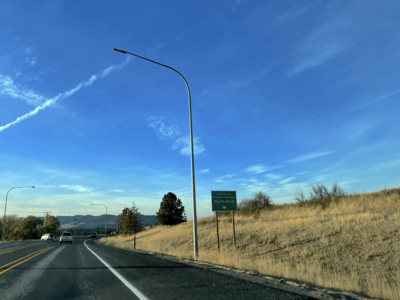
This is the exit to Valleyford from Washington State Route 27. You can see TV towers in the background.
-
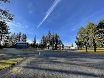
This picture shows the main intersection in Valleyford. Madison Road meets the Palouse Highway here.
-
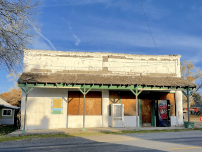
This is an old, empty market building near the center of Valleyford.


See also
 In Spanish: Valleyford (Washington) para niños
