
Riverfront Park (Spokane, Washington) facts for kids
Quick facts for kids Riverfront Park |
|
|---|---|
.svg) 
Riverfront Park in 2005.
|
|
| Type | Urban park |
| Location | Riverside, Spokane, Washington, U.S. |
| Area | 100 acres (0.40 km2) |
| Operated by | Spokane Parks & Recreation Department |
| Visitors | about 3 million annually |
| Status | Open year round (daily, 6 am to midnight) |
| Website | RiverfrontSpokane.org |
Riverfront Park, also known as Riverfront Spokane, is a fun public park in downtown Spokane, Washington. The Spokane Parks & Recreation Department takes care of it. This 100-acre park sits right along the beautiful Spokane River. It includes the amazing Upper Spokane Falls, which is the biggest city waterfall in the United States.
Long ago, this area was a special meeting place for Native American tribes. They gathered here to fish for salmon near the powerful falls. Later, in the 1870s, settlers arrived and built sawmills. They used the river's strong current to power their machines. Over time, the area became busy with factories and mills. These used the hydropower from the Spokane Falls to create electricity. Today, you can still see some of these historic power facilities in the park.
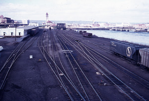
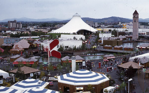
For many years, the park area was a busy railyard with lots of train tracks. People dreamed of turning it into a beautiful park to show off the Spokane Falls. This dream came true in 1972. The train tracks were removed to make way for Expo '74, a special World's fair focused on the environment. After the fair ended in November 1974, the site was turned into Riverfront Park. It officially opened in 1978. Some famous buildings from Expo '74, like the U.S. Pavilion, are still part of the park. You can also find historic spots like the Great Northern clock tower and the amazing Looff Carrousel. The park welcomes over three million visitors every year. It's a great place to explore and learn about Spokane's history.
Contents
- Exploring Riverfront Park: Location and Layout
- Park History: From Falls to Fair to Park
- Riverfront Park Attractions and Features
- Natural Beauty: River, Falls, and Green Spaces
- Park Wildlife: Animals You Might See
- Structures and Built Attractions
- Great Northern Railway Clock Tower
- U.S. Pavilion: A Landmark for Events
- Looff Carrousel: A Historic Ride
- Red Wagon: A Giant Play Sculpture
- Numerica SkyRide: Views from Above
- Numerica Skate Ribbon: Skating Fun Year-Round
- Sister Cities Connections Garden
- Providence Playspace: An Inclusive Playground
- Ice Age Floods Playground and Skate and Wheels Park
- Spokane Humane Society Paw Park: A Place for Dogs
- Public Art: Sculptures and Creations
- Past Park Features
- Hydropower: The River's Energy
- Festivals and Events at Riverfront Park
Exploring Riverfront Park: Location and Layout

Park Geography: Islands and Waterfalls
Riverfront Park is just north of downtown Spokane. It's in the Riverside neighborhood. The park is bordered by Spokane Falls Boulevard to the south and the Spokane River to the north. Its height is mostly similar to downtown Spokane. But it changes as you go onto the park's islands or closer to the river.
The Spokane River and its amazing waterfalls are the park's main natural features. The river flows through the park from east to west. It splits into three channels, forming two main islands. The first split creates Havermale Island, which is the bigger island. Further along, the northern channel splits again. This creates snxw meneɂ Island. This name means "Salmon People" Island in the Salish language. These channels surround the Upper Spokane Falls. The Upper Spokane Falls is the second largest city waterfall in the United States.
Park Areas: Exploring the Different Sections

Riverfront Park has a few main areas. These include the South Channel area, Havermale Island, and the North Bank area. The South Channel area is along the southern part of the Spokane River. Here you'll find the Looff Carrousel, the Numerica Skate Ribbon, and the Rotary Fountain. This area is also the main entrance to the park from the south.
If you cross the South Channel, you reach Havermale Island. This island has grassy meadows, natural areas, and outdoor theaters. It's also home to the U.S. Pavilion and the Great Northern clock tower. The northern part of the park is called the North Bank. It's across the Spokane Falls from Havermale Island. This area was updated in 2021. It now has an ice age floods-themed playground and basketball courts. There's also a Skate and Wheels Park and a climbing boulder. The Howard Street Promenade offers great views of the Spokane Falls. Next to the North Bank playground is The Podium. This is a large sports building that opened in 2021.
Connecting to the City: Park Access

Riverfront Park is right in the middle of downtown Spokane. This means it's surrounded by city life. The park's southern edge, along Spokane Falls Boulevard, connects directly to downtown. This creates a clear line between the city and the park.
The park is well-connected to the areas around it. Sidewalks along the park's edges lead right into its plazas and lawns. Buildings like the First Interstate Center for the Arts and Spokane Convention Center are also connected. They have special walkways and terraces that make it easy to go between the buildings and the park. Even though the northern side has more natural riverbanks, there are still paths and roads that lead into the park.
Many paths also run through the park itself. The Howard Street Promenade goes from south to north. It connects downtown Spokane to the North Bank areas. This path makes it easy to walk straight through the park. Other bridges also cross the Spokane River. These include suspension bridges for walkers and the Washington Street Bridge for cars and people.
Spokane River Centennial Trail
The Spokane River Centennial Trail is a long path that runs through the park. It's 37 miles long and connects to another trail in Idaho. The trail enters Riverfront Park from the east. It passes by many attractions like the Spokane Convention Center and the Looff Carrousel. The trail then leaves the park to the west. It continues towards Riverside State Park.
Park History: From Falls to Fair to Park
Early Site History: Native Americans and Industry
.jpeg)
The story of Riverfront Park began with the Spokane Falls. Early settlers chose this spot because the falls could power their businesses. But over time, factories and railroads took over the area. This hid the beautiful falls from view.
The park's site was first home to Native American tribes. They set up fishing camps near the falls. Tribes from all around would meet here to fish for salmon. They also traded and held cultural events. They used special traps to catch salmon. Then they dried and smoked the fish to save it for winter. A "Salmon Chief" would lead the fishing and share the catch fairly.
American settlers arrived in 1871. In 1873, James N. Glover bought land and a sawmill near the falls. He knew the river's power was valuable. He also knew the Northern Pacific Railroad Company planned to build tracks nearby.
.jpeg)
By the late 1800s, the area around the falls was full of sawmills, flour mills, and power generators. The Great Northern Railway built tracks into downtown Spokane in 1892. By 1902, trains were running through the city center. This started an era where railroads dominated downtown Spokane.
Spokane became a major railroad center in the western United States. Four large railroads and other regional lines came through the city. In 1908, the Olmsted Brothers, who planned parks, noticed this. They hoped the city would one day turn the area around the falls into a public park.
By 1914, the Union Pacific also built a station on the park's site. Downtown Spokane became a busy hub for trains. But by the mid-1900s, all the railroads caused problems. They blocked views of the Spokane River and its falls. They also made downtown noisy and caused traffic jams.
From Railyard to Park: Expo '74 and Urban Renewal
In the 1950s, downtown Spokane started to lose people to the suburbs. Local business leaders formed a group called Spokane Unlimited in 1959. They wanted to bring downtown back to life. Their plan in 1961 suggested removing the train tracks. They wanted to make the Spokane River beautiful again.
The plan was to renew the area over two decades. But voters did not approve funding for a new government center. So, Spokane Unlimited hired King Cole to help. Cole created a citizen group to build support for making the riverfront beautiful. They wanted to turn Havermale Island into a park.
In 1970, a study suggested Spokane host an international exposition. This would bring in money from the state and federal governments. It would also attract tourists. This idea caught on, and Spokane decided to host the 1974 World's Fair.
Hosting the fair was a big challenge. Spokane was the smallest city to host a World's Fair. The site also had many owners, including the railroads. Funding came from local, state, and federal sources. President Richard Nixon officially recognized the event in October 1971.
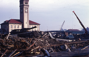
The biggest challenge was removing the railroads. Expo '74 planners, including King Cole, convinced the railroads to swap land. The train lines were moved south of downtown. This cleared the site for construction. The environmentally-themed Expo '74 was held from May to November 1974. It welcomed nearly 5.6 million visitors.
After the fair, the site became Riverfront Park. Landscape architects designed it to highlight the natural falls. They used spots that were once industrial buildings for viewing areas. Paths connect different parts of the park. The park was officially opened in 1978 by President Jimmy Carter. About 50,000 people attended the ceremony.
Modern Updates: The 2016–2021 Redevelopment
.jpg)
Riverfront Park stayed mostly the same for many years. But its buildings and features started to get old. In 2012, Spokane Park Board decided to update the park. They wanted to make it exciting for a new generation.
A new master plan was finished in 2014. Spokane voters then approved a $64.3 million bond to redevelop the park. This bond did not raise taxes. It replaced an old park tax that was ending. The money was used to renovate the U.S. Pavilion. It also built a new skate ribbon and a new home for the Looff Carousel. New public spaces like the Howard Street Promenade and a playground were also created.
Construction began in 2016. The final major part, the north bank playground, opened in May 2021. Another project, The Podium sportsplex, also finished in 2021. The Post Street Bridge, on the park's western edge, was renovated and reopened in June 2024.
Riverfront Park Attractions and Features
Natural Beauty: River, Falls, and Green Spaces

The Spokane River and Spokane Falls are the park's main natural attractions. You can see them from many places. Along the calm south channel, paths and lawns go right up to the water. People sometimes put their feet in the water or fish there. The north channel has faster, rougher water because of the falls. But there are special viewing spots. Two pedestrian suspension bridges offer close-up views of the falls.
Riverfront Park has many open grassy areas. These are on the south side of Havermale Island. They face the calm Spokane River channel. The Lilac Bowl is a natural outdoor theater. The Clock Tower Meadow is next to the Great Northern clock tower.
The park also has native plants. These help create a natural environment. The Riverfront Park Conservation Area is about 1 acre. It runs along the falls and highlights a stream.
Park Wildlife: Animals You Might See
You might spot many animals in the park. These include marmots, osprey, beaver, and mule deer. Ducks, Canada geese, and squirrels are also common. Marmots are often seen around the river and park. This is unusual because they usually live in mountains.
Structures and Built Attractions
.jpg)
Riverfront Park is also famous for its buildings and attractions. The U.S. Pavilion and Great Northern clock tower are two of Spokane's most famous landmarks. They have been on the park's logo for many years. The latest logo, from 2017, uses modern shapes inspired by these landmarks.
Great Northern Railway Clock Tower
The Great Northern Railway clock tower is on Havermale Island. It was built in 1902. It was part of the Great Northern Railway Depot. This depot was on the park site before Expo '74. When the train tracks were removed, the depot was torn down in 1973. But people wanted to save the clock tower. It now stands as a Spokane icon. It reminds everyone of the important role railroads played in Spokane's growth. You can still see where the depot's roofline met the tower. The brick changes color at that spot.
The tower is 155 feet and 6 inches tall. It has a 9-foot wide clock face on all four sides. A heavy 700-pound brass pendulum controls the clock. Park staff must wind it by hand every week. The clock chimes every hour. It has always used electronic speakers to make the chime sounds.
U.S. Pavilion: A Landmark for Events
The U.S. Pavilion is a steel and cable structure. It's in the center of Riverfront Park on Havermale Island. It's also called the Pavilion at Riverfront. This building was the United States' pavilion during Expo '74. Today, it's an event center with indoor and outdoor spaces. It also has an outdoor theater for concerts and shows. When no events are happening, it's an open public space. It offers great views of the Spokane River.
Pavilion History: From Expo to Today
,_Riverfront_Park,_Spokane,_WA_(53796721800).jpg)
The U.S. government decided to join Expo '74 in 1971. President Richard Nixon officially recognized the fair. The fair's theme was the environment. The U.S. wanted to show its efforts in protecting nature. They also hoped to boost trade by showing anti-pollution equipment.
The government decided to build a pavilion for its exhibit. They wanted the pavilion to be permanent. It would stay after the fair as part of a civic center and urban park. The City of Spokane gave a four-acre plot of land for the Pavilion. Before the fair, a motel stood on this land.
Many architecture firms competed to design the Pavilion. Seattle-based Naramore, Bain, Brady & Johanson (now NBBJ) won the final design contract in 1973. The Pavilion was designed to look like a giant tent. It was originally covered. This design fit the fair's environmental theme. It was the largest building at the fair. The U.S. Congress provided $11.5 million to build it.
Construction began on May 1, 1973. The Pavilion's tower is 150 feet tall. It uses about 4.6 miles of cables. The original vinyl covering was removed in 1979. Since then, the Pavilion has had its famous open, skeleton-like look.
Pavilion Renovation: A New Look

The Pavilion was fully renovated in 2018. This was part of Riverfront Park's big redevelopment. The old IMAX theater and other structures were removed. The renovated Pavilion reopened on September 6, 2019. It now has an open floor for events. Sloped seating areas are perfect for audiences. A 40-foot high platform in the center offers views of the Spokane River.
The new design added plexiglass "blades" with LED lights to the cables. These blades light up the Pavilion at night. There are 476 blades of different lengths. They can display animated light shows. These shows happen from dusk to 10 pm on Fridays, Saturdays, and Sundays. Special shows are created for holidays. In 2020, the lighting design won awards.
Looff Carrousel: A Historic Ride

Riverfront Park has a beautiful hand-carved carousel. It was built by Charles I. D. Looff, a famous carousel maker. He built the first carousel at Coney Island. Spokane's carousel was a wedding gift from Looff to his daughter in 1909. It was first at Natatorium Park until 1968.
The carousel was moved to Riverfront Park in 1975. It was placed in a building that was once a German restaurant during Expo '74. The carousel operated there until 2016. Then it closed for the park's redevelopment.
During the renovation, the carousel was stored and fixed up. Its old building was replaced with a new one. The new building opened on May 12, 2018. The carousel still operates today and is on the National Register of Historic Places.
Red Wagon: A Giant Play Sculpture

The Red Wagon, officially called The Childhood Express, is a giant play sculpture. It looks like a huge Radio Flyer wagon. You can find it along Spokane Falls Boulevard. It's between the First Interstate Center for the Arts and the Looff Carousel.
Local artist Ken Spiering created this sculpture. It is 12 feet high and 27 feet long. It weighs 26 tons and is made of steel and concrete. The Junior League commissioned it for Washington State's Centennial celebration. It was dedicated to Spokane's children on August 18, 1990.
You can go inside the wagon using a staircase at the back. A wooden platform covers the inside. You can walk around and look out. The wagon's handle is a fun playground slide. This is another way to exit the sculpture. In May 2022, the Red Wagon received its first major repairs and a fresh coat of paint.
Numerica SkyRide: Views from Above

The Numerica SkyRide is a gondola lift ride. It's at the southeast corner of Riverfront Park. The ride takes you west from the park. You'll pass Spokane City Hall and go over Huntington Park. Then you descend into the Spokane River gorge. You get amazing views of the Lower Spokane Falls. The ride crosses the river and loops back to the park.
The current SkyRide was built in 2005. The original ride was from the 1960s. It was bought for Expo '74. It had open-air gondolas. The 2005 reconstruction replaced the whole system. It upgraded the ride with fully enclosed gondolas.
Numerica Credit Union bought the naming rights for the SkyRide in 2019. They also named the nearby Numerica Skate Ribbon. This deal helps support the park's programs and maintenance.
Numerica Skate Ribbon: Skating Fun Year-Round

The Numerica Skate Ribbon opened in 2017. It was part of Riverfront Park's redevelopment. This venue is at the southwest corner of the park. It's across from River Park Square and Spokane City Hall. The ribbon is a year-round skating spot. You can roller skate in warm weather. In winter, it becomes an ice skating rink.
The facility also has a café. It hosts other events like art walks and weddings. The ribbon replaced the seasonal Ice Palace. The Ice Palace was an ice rink under the U.S. Pavilion. The new ribbon has a 715-foot winding and sloped path. Some people worried it wouldn't be as good for hockey or large skating classes.
In 2019, Numerica Credit Union bought the naming rights for the Skate Ribbon. This deal helps fund the park's activities and upkeep.
Sister Cities Connections Garden
A special garden and plaza opened in September 2019. It's northwest of the Howard Street footbridge. This garden has sculptures that honor Spokane's five sister cities. These cities are Nishinomiya, Jilin, Jecheon, Limerick, and Cagli. There are also sculptures for Spokane itself.
The garden includes a golden harp in glass for Limerick. An 11-foot tall replica of the Imazu Lighthouse represents Nishinomiya. A 5-foot fish sculpture honors Spokane and Native American tribes. Sculptures for the other sister cities will be added later.
Providence Playspace: An Inclusive Playground
The Providence Playspace opened in October 2020. It's on the park's south end, near the Upper Falls Power Plant. This playground was funded by donations. Providence Health & Services gave $1 million. It's a Shane's Inspiration playground. This means it's designed to be inclusive. All children, including those with disabilities, can play here. It's the first of its kind in Spokane.
The playground is 11,600 square feet. It has 20 different play pieces. These include a sand box table for touching and feeling. There's also a "cozy dome" for quiet time. Several pieces let kids make music.
Ice Age Floods Playground and Skate and Wheels Park

The North Bank park was the final major part of the 2014 park bond project. It's 40,000 square feet. It includes the Ice Age Floods Playground and the Skate and Wheels Park. This area was designed for all ages and interests. It officially opened on May 21, 2021.
The Ice Age Floods Playground is themed after the Missoula floods. These floods shaped the region's landscape. It's a fun way for kids to learn while they play. It has a three-story Columbian slide tower. There's a Glacial Dam splash pad and a log-jam climbing wall. You can also dig for "fossils." The climbing wall represents an ice dam. It has a quote from geologist J Harlen Bretz. He studied the ice age floods. In the center is the Roskelley Performance Climbing Boulder. This climbing rock honors Spokane mountaineer Jess Roskelley. It has his motto: "fortitudine vincimus" (by endurance, we conquer).
The Skate and Wheels Park is an 8,000 square foot skatepark. It was designed with ideas from the public. It replaced an old skatepark under Interstate 90. The new park has street features, a wallride, and two bowls.
Spokane Humane Society Paw Park: A Place for Dogs
The City of Spokane announced plans for a dog park in February 2022. It will be on Havermale Island. It will use the old Expo '74 forestry shelter. This shelter has wood beams and a high roof. It was meant to feel like being in a forest. The shelter will provide shade for the dog park. The Spokane Parks Foundation is raising $750,000 for the park. The Spokane Humane Society gave $250,000.
Public Art: Sculptures and Creations
.jpg)
.jpg)
.jpg)

Riverfront Park has many art installations. They make up about half of all the sculptures in downtown Spokane. One is a restored 50-foot tall butterfly sculpture from Expo '74. Its fabric wings move and rotate in the wind. More sculptures have been added over the years. They come from many different artists and styles.
The art pieces have different purposes. Some are memorials, like for Vietnam War veterans. Others honor famous locals like astronaut Michael P. Anderson. Some celebrate local Native American heritage. There are also fun, interactive play sculptures.
Local artist Harold Balazs has several pieces in the park. His Centennial Sculpture is an abstract aluminum piece floating in the Spokane River. He also designed the Rotary Fountain. Two new artworks were added during the park's 50th anniversary redevelopment.
Garbage Goat: A Fun Way to Recycle
One of the park's most popular art pieces is Goat. It was installed in 1974 for Expo '74. People often call it the "Garbage Goat" or the "Garbage Eating Goat." It's located east of the Looff Carousel.
This sculpture fits Expo '74's environmental theme. It's an interactive art piece that collects small trash. It was sponsored by the Spokane Women's Council of Realtors. Sister Paula Mary Turnbull, a local nun, sculpted it. The corten steel goat has a vacuum inside. It sucks up small pieces of garbage through its mouth. You can "feed" it your trash!
Before it was installed, some dairy goat farmers protested. They worried the sculpture would make people think goats eat anything. They wanted people to know that real goats need proper food. A compromise was reached. The garbage goat was installed. Real dairy goats at the fair got signs. These signs explained that proper food helps them produce milk.
Over the years, the goat has become very popular. Many generations of Spokane families love it. The goat has an unofficial Facebook page with thousands of followers. The Spokane County Solid Waste System even named its educational blog after it. For its 40th birthday, the city held a celebration. They "fed" the goat a slice of birthday cake. There was also a goat-themed party for the public.
Past Park Features

.jpg)
Before its big redevelopment, Riverfront Park had these features:
- The Ice Palace was a seasonal ice skating rink. It was set up under the U.S. Pavilion. It operated from 1977 until 2017. The permanent Numerica Skating Ribbon replaced it.
- The IMAX Theater was part of the U.S. Pavilion. It opened in 1978. It was very popular in 2005. But attendance dropped when another IMAX opened nearby. It also lost licenses for big Hollywood movies. The theater closed in 2016 and was torn down in 2018.
- The Pavilion Rides were a collection of amusement rides. The City of Spokane owned them. They were set up each summer under the U.S. Pavilion. These rides did not fit the new vision for the Pavilion. They were removed in 2014. The Spokane Park Board decided not to build a new spot for them. Several rides were sold off.
Hydropower: The River's Energy
Early Hydropower: Powering Spokane's Growth
.jpeg)
The fast-moving Spokane River and its falls have been used for power since the 1870s. Early settlers used waterwheels to run sawmills and flour mills. On September 2, 1885, hydroelectricity first powered Spokane. It lit up 10 to 11 lights in downtown. George A. Fitch installed a generator in a flour mill.
As more electricity was needed, Fitch's company grew. They bought 1,200 light bulbs from Thomas Edison's company. They also agreed to use only Edison's equipment. A new power plant was built on the Spokane River's North Channel. It powered the city's first opera house. The company later became the Edison Electric Illuminating Co. of Spokane Falls (EEICSF).
By the late 1880s, the demand for electricity was huge. This led to new power companies forming. One was Washington Water Power (now Avista Utilities) in 1889. Even though some thought steam power was better, these companies kept investing in hydropower.
.jpg)
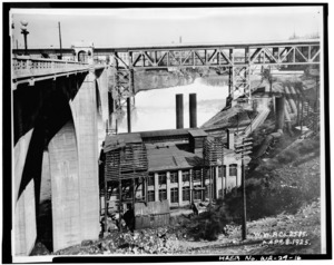
Washington Water Power was building a generator on the Lower Spokane Falls. Then the Great Spokane Fire happened in August 1889. After the city rebuilt, electricity demand grew even faster. Washington Water Power built a larger power plant and an 18-foot tall timber dam. This became the Monroe Street Power Station, finished in 1890. It had a huge power capacity. Washington Water Power soon bought out other smaller companies. They combined all the generators into the Monroe Street Power Station.
Modern Hydropower: Dams and Power Plants

In 1922, Washington Water Power built another dam. It was called the Upper Falls Diversion Dam. It's at the eastern tip of Havermale Island. This dam sends water through the river's South Channel. This water powers a 10 MW generator at the Upper Falls Power Plant.
The timber Monroe Street Dam was damaged by high water. It was replaced with a concrete dam in 1974. This was just before Expo '74. Huntington Park was also built next to Riverfront Park. It let visitors see water going into the plant's turbines. In 1992, the Monroe Street Power Station was updated. Its old generator was replaced with a new 15-MW one. The old generator was given to the Henry Ford Museum.
Hydropower's Legacy: Shaping the Park
.jpg)
The history of hydropower on the Spokane Falls is still visible in Riverfront Park. It's a big part of the park's attractions. Huntington Park and the Monroe Street Power Station are key sights on the Numerica SkyRide. In 2014, Huntington Park was renovated. A new plaza was added in front of Spokane City Hall. This connected the two parks.
Hydropower on the Upper Spokane Falls also shaped the park. The Upper Falls Power Plant is a park attraction. The Upper Falls Diversion Dam created the calm waters of the South Channel. This channel is home to many attractions. These include the Looff Carousel, Red Wagon, and First Interstate Center for the Arts. The calm water allows visitors to interact with the river. Avista Utilities' Post Street Electric Substation is home to the Mobius Science Center.
Festivals and Events at Riverfront Park

Riverfront Park hosts many popular Spokane events every year:
- The annual Lilac Bloomsday Run in May. The park is where post-race activities happen.
- Spokane Hoopfest in June. The park hosts exhibitors, vendors, and the Nike Center Court.
- The Fourth of July festival and fireworks display.
- The Royal Fireworks Concert. This annual concert ends with Handel's music and fireworks.
- Gathering at the Falls Powwow. This summer event celebrates Native American culture.
- Unity in the Community. An annual celebration of diversity.
- Pig Out in the Park. A food and music festival held during Labor Day weekend.
