Spangle, Washington facts for kids
Quick facts for kids
Spangle, Washington
|
|
|---|---|

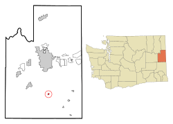
Location of Spangle, Washington
|
|
| Country | United States |
| State | Washington |
| County | Spokane |
| Area | |
| • Total | 0.35 sq mi (0.91 km2) |
| • Land | 0.35 sq mi (0.91 km2) |
| • Water | 0.00 sq mi (0.00 km2) |
| Elevation | 2,444 ft (745 m) |
| Population
(2010)
|
|
| • Total | 278 |
| • Estimate
(2019)
|
319 |
| • Density | 914.04/sq mi (352.41/km2) |
| Time zone | UTC-8 (Pacific (PST)) |
| • Summer (DST) | UTC-7 (PDT) |
| ZIP code |
99031
|
| Area code | 509 |
| FIPS code | 53-66290 |
| GNIS feature ID | 1512681 |
Spangle is a small city located in Spokane County, Washington, in the United States. It is named after William Spangle, who was one of the first people to settle there. According to the 2010 census, about 278 people lived in Spangle.
Contents
History of Spangle
When Was Spangle First Settled?
William Spangle first settled in this area in 1872. Later that same year, his two children planted a special tree. They called it "Branchy." This tree marked the beginning of their new community. Even today, Branchy still stands tall in the middle of town.
When Did Spangle Become a City?
The town's layout was officially planned in 1879. Spangle then became an incorporated city in 1888. This means it officially became a city with its own local government.
Geography of Spangle
Where is Spangle Located?
Spangle is located at coordinates 47.430641 degrees North and -117.377083 degrees West. This places it in the eastern part of Washington state.
How Big is Spangle?
The city covers a total area of about 0.36 square miles (0.93 square kilometers). All of this area is land, with no water.
What is Around Spangle?
Spangle is about 18 miles south of Downtown Spokane. It sits along US Route 195, which is an important highway. This highway used to go right through the town. However, the highway was changed to go around Spangle and other small towns. The old highway is still open between Spangle and Rosalia, which is 14 miles (23 km) to the south. This offers another way to travel. The city is surrounded by the beautiful rolling farmlands of the Palouse region.
People of Spangle
| Historical population | |||
|---|---|---|---|
| Census | Pop. | %± | |
| 1880 | 36 | — | |
| 1890 | 303 | 741.7% | |
| 1900 | 331 | 9.2% | |
| 1910 | 299 | −9.7% | |
| 1920 | 291 | −2.7% | |
| 1930 | 218 | −25.1% | |
| 1940 | 203 | −6.9% | |
| 1950 | 242 | 19.2% | |
| 1960 | 208 | −14.0% | |
| 1970 | 179 | −13.9% | |
| 1980 | 276 | 54.2% | |
| 1990 | 229 | −17.0% | |
| 2000 | 240 | 4.8% | |
| 2010 | 278 | 15.8% | |
| 2019 (est.) | 319 | 14.7% | |
| U.S. Decennial Census 2015 Estimate |
|||
Population in 2010
In 2010, there were 278 people living in Spangle. These people lived in 118 different homes. About 74 of these were families.
The city had about 772 people per square mile. There were 126 housing units in total. Most of the people living in Spangle were White (97.5%). A small number were Native American (1.4%) or Asian (0.4%).
About 30.5% of homes had children under 18 living there. Many homes (49.2%) were married couples. The average home had 2.36 people. The average family had 2.97 people.
The average age of people in Spangle was 40.8 years old. About 21.9% of residents were under 18. And 19.8% were 65 years or older.
Education in Spangle
Schools in the Area
Spangle is home to two important schools: Upper Columbia Academy and Liberty High School.
- Upper Columbia Academy: This is a boarding high school. This means students can live at the school. It is connected with the Seventh-day Adventist Church. The academy is about 2 miles southeast of Spangle.
- Liberty High School: This school is about 5.5 miles east of Upper Columbia Academy. It serves students from Spangle and nearby communities like Plaza, Fairfield, Mount Hope, Latah, and Waverly. It is a "B" school and has about 450 students from kindergarten to 12th grade.
See also
 In Spanish: Spangle (Washington) para niños
 | Aaron Henry |
 | T. R. M. Howard |
 | Jesse Jackson |

