Felts Field facts for kids
Quick facts for kids
Felts Field
|
|||||||||||||||
|---|---|---|---|---|---|---|---|---|---|---|---|---|---|---|---|
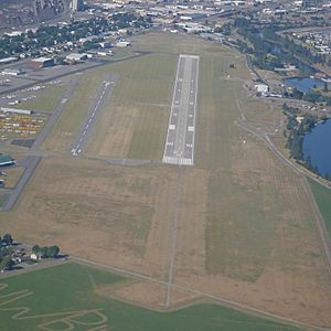
Felts Field looking west
|
|||||||||||||||
| Summary | |||||||||||||||
| Airport type | Public | ||||||||||||||
| Owner | Spokane City-County | ||||||||||||||
| Serves | Spokane, Washington | ||||||||||||||
| Elevation AMSL | 1,957 ft / 596 m | ||||||||||||||
| Coordinates | 47°40′59″N 117°19′21″W / 47.68306°N 117.32250°W | ||||||||||||||
| Map | |||||||||||||||
| Runway | |||||||||||||||
|
|||||||||||||||
| Statistics | |||||||||||||||
|
|||||||||||||||
|
Source: Federal Aviation Administration
|
|||||||||||||||
Felts Field is a public airport. It is located about five miles northeast of downtown Spokane, Washington. The airport is in Spokane County, Washington. Spokane City-County owns and operates it.
Felts Field has two runways. Today, it is mostly used for general aviation. This means it handles private planes, flight training, and smaller aircraft. Before the Spokane International Airport opened, Felts Field was Spokane's main airport for commercial airlines.
The Federal Aviation Administration (FAA) calls Felts Field a "regional reliever facility." This means it helps reduce air traffic at larger airports.
Contents
Discovering Felts Field's History
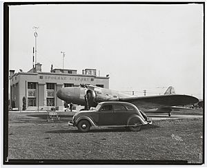
Felts Field is a very old airport in Spokane. It sits on the south bank of the Spokane River. Airplanes first started using this area in 1913. In 1920, the airport was called the Parkwater airstrip. The Spokane Chamber of Commerce helped make it a city flying field.
In 1926, the United States Department of Commerce officially recognized Parkwater as an airport. It was one of the first airports in the western United States. In September 1927, the airport hosted the National Air Races. During this event, the airport was renamed Felts Field.
Who Was James Buell Felts?
The airport was named after James Buell Felts. He was a pilot in the Washington Air National Guard. Sadly, he died in a plane crash in May 1927. Renaming the airport honored his memory.
Early Aviation at Felts Field
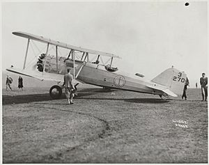
Parkwater Aviation Field, later Felts Field, was a busy place. It offered flight lessons for new pilots. You could also find charter services there. These services allowed people to rent a plane for a special trip. Airplane repair shops also operated at the field.
Pilots used Felts Field for aerial photography. This means taking pictures from an airplane. The 116th Observation Squadron of the Washington Air National Guard also had its headquarters here. Felts Field was also where the first airmail and commercial flights in Spokane began.
Felts Field Today
In the summer of 1946, major airlines like Northwest and United moved their flights. They moved to Geiger Field, which later became Spokane International Airport. Even after this, Felts Field remained busy. It is still an important place for private and small-plane aviation. Many businesses related to aviation also operate there.
In 1991, Felts Field was recognized as a historic place. It was added to the National Register of Historic Places. This means it is an important part of history. Today, the airport is mainly for general aviation. There are no regular passenger flights. However, cargo planes still use Felts Field to deliver packages. Companies like UPS and DHL use contractors for these cargo operations.
Airport Features and Operations
Felts Field covers about 416 acres (168 hectares) of land. It is located at an elevation of 1,957 feet (596 meters) above sea level.
Runways and Landing Areas
The airport has two main runways:
- Runway 4L/22R is 4,499 feet (1,371 meters) long and 150 feet (46 meters) wide. It is made of concrete.
- Runway 4R/22L is 2,650 feet (808 meters) long and 75 feet (23 meters) wide. It is made of asphalt.
Felts Field also has a special landing area for seaplanes. This area is called 3W/21W. It is 6,000 feet (1,829 meters) long and 100 feet (30 meters) wide.
Aircraft Activity
In the year ending February 28, 2015, Felts Field had 54,881 aircraft operations. This means about 150 planes took off or landed each day. Most of these operations (93%) were for general aviation. About 7% were air taxi services, and less than 1% were military flights.
In July 2017, 176 aircraft were based at Felts Field. This number includes:
- 146 single-engine planes
- 15 multi-engine planes
- 15 helicopters
 | May Edward Chinn |
 | Rebecca Cole |
 | Alexa Canady |
 | Dorothy Lavinia Brown |


