Ford, Washington facts for kids
Quick facts for kids
Ford, Washington
|
|
|---|---|
| Country | United States |
| State | Washington |
| County | Stevens |
| Elevation | 1,785 ft (544 m) |
| Time zone | UTC-8 (Pacific (PST)) |
| • Summer (DST) | UTC-7 (PDT) |
| ZIP code |
99013
|
| Area code(s) | 509 |
| GNIS feature ID | 1504949 |
Ford is a small place in Stevens County, Washington, in the United States. It's called an unincorporated community because it doesn't have its own local government like a city or town. Instead, it's part of the larger county.
Ford is located about 10.5 miles (16.9 km) south-southwest of Springdale. It has its own post office with the ZIP code 99013. There's also a community church in Ford that welcomes everyone.
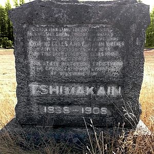
A special historical marker stands near Ford. It remembers the Tshimakain Mission, an important place from the past.
Where is Ford, Washington?
Ford is in the southern part of Stevens County. It's about five miles north of the Spokane River. This river forms the southern border of the county.
Chamokane Creek flows through Ford. This creek is important because it forms the edge of the Spokane Indian Reservation. The reservation is right next to Ford, on its western side.
Getting Around Ford
The main road through Ford is Washington State Route 231. This road connects Ford to Springdale in the north. It also goes south to Reardan.
About five miles south of Ford, you can find a connection to Washington State Route 290. This road leads to Spokane, which is a bigger city and a center for shopping and business in the region.
There's also the Ford-Wellpinit Road. This road goes west from Ford into the Spokane Indian Reservation. It leads to the community of Wellpinit, which is about 10 miles away.
Nature Around Ford
Ford is in a hilly area. It sits at the base of Happy Hill, which is over 600 feet tall. The land around Chamokane Creek is quite flat. This flat area is called Walkers Prairie. It's about 1,700 to 1,800 feet above sea level.
See also
 In Spanish: Ford (Washington) para niños
 | DeHart Hubbard |
 | Wilma Rudolph |
 | Jesse Owens |
 | Jackie Joyner-Kersee |
 | Major Taylor |


