
SeaTac, Washington facts for kids
Quick facts for kids
SeaTac, Washington
|
||
|---|---|---|

Aerial view of SeaTac, featuring Angle Lake
|
||
|
||

Location of SeaTac, Washington
|
||
| Country | United States | |
| State | Washington | |
| County | King | |
| Incorporated | February 28, 1990 | |
| Named for | Seattle–Tacoma International Airport | |
| Government | ||
| • Type | Council–manager | |
| Area | ||
| • Total | 10.239 sq mi (26.519 km2) | |
| • Land | 10.064 sq mi (26.066 km2) | |
| • Water | 0.175 sq mi (0.454 km2) | |
| Elevation | 269 ft (82 m) | |
| Population
(2020)
|
||
| • Total | 31,454 | |
| • Estimate
(2023)
|
31,799 | |
| • Density | 3,159.79/sq mi (1,220.00/km2) | |
| Time zone | UTC–8 (Pacific (PST)) | |
| • Summer (DST) | UTC–7 (PDT) | |
| ZIP Codes |
98148, 98158, 98168, 98188, 98198
|
|
| Area code(s) | 206 | |
| FIPS code | 53-62288 | |
| GNIS feature ID | 1534053 | |

SeaTac is a city in southern King County, Washington, in the United States. It is a suburb of Seattle and part of the larger Seattle metropolitan area. The city's name, "SeaTac," comes from the Seattle–Tacoma International Airport. This airport's name is a portmanteau, which means it combines parts of the names of two nearby cities: Seattle and Tacoma.
The city of SeaTac covers about 10 square miles (26 square kilometers). In 2020, its population was 31,454 people. The city completely surrounds the Seattle–Tacoma International Airport, which is about 3 square miles (8 square kilometers) in size. The Port of Seattle owns and runs the airport. Before SeaTac became a city, it included smaller communities like Angle Lake, Bow Lake, McMicken Heights, and Riverton Heights. Residents voted to make SeaTac a city on March 14, 1989. The city officially started in February 1990.
Contents
History of SeaTac
The area known as Highline includes modern-day SeaTac, Burien, most of Des Moines, and other communities. European Americans began settling here in the mid-1850s.
In 1860, the government finished building a military road. This road went from Fort Steilacoom to Fort Bellingham, passing through the Highline area. Later, in the early 1900s, Des Moines Memorial Drive became an important road for travel between Seattle and Tacoma. This road goes right through the middle of the SeaTac and Burien areas.
In the 1980s, people living in the area wanted to form their own city. Some also suggested joining nearby cities like Des Moines. On March 14, 1989, local residents voted to become a city. SeaTac officially became a city on February 28, 1990. The original vote used the name "Sea-Tac" with a hyphen, but the official paperwork dropped it.
SeaTac's Economy

SeaTac is home to more than 900 businesses. Nearly 80 of these are large companies listed in the Fortune 1000. These businesses employ almost 40,000 people in SeaTac. They also generate about $3.7 billion in local sales.
Two major airlines, Alaska Airlines and Horizon Air, have their main offices in SeaTac. Other international airlines, like Asiana Airlines, EVA Air, Hainan Airlines, and China Airlines, also have operations in the city.
Economic Growth
In 2011, SeaTac created its Department of Community and Economic Development. This department helps businesses get permits more easily. It also works to support new real estate projects and create jobs in the city. The department has four main parts: Economic Development, Planning, Engineering Review, and Building Services.
In 2013, the people of SeaTac voted on Proposition No. 1. This vote passed, which meant the city's minimum wage was raised to $15 per hour.
Geography and Climate
SeaTac is located at 47°27′13.36″N 122°19′18.45″W / 47.4537111°N 122.3217917°W.
The city covers a total area of about 10.239 square miles (26.519 square kilometers). Most of this area, 10.064 square miles (26.066 square kilometers), is land. The remaining 0.175 square miles (0.454 square kilometers) is water.
| Climate data for Seattle (SeaTac Airport), 1981–2010 normals, extremes 1894–present | |||||||||||||
|---|---|---|---|---|---|---|---|---|---|---|---|---|---|
| Month | Jan | Feb | Mar | Apr | May | Jun | Jul | Aug | Sep | Oct | Nov | Dec | Year |
| Record high °F (°C) | 67 (19) |
70 (21) |
78 (26) |
89 (32) |
93 (34) |
98 (37) |
103 (39) |
99 (37) |
98 (37) |
89 (32) |
74 (23) |
66 (19) |
103 (39) |
| Mean maximum °F (°C) | 56.4 (13.6) |
60.3 (15.7) |
66.0 (18.9) |
74.7 (23.7) |
81.5 (27.5) |
85.5 (29.7) |
90.6 (32.6) |
88.8 (31.6) |
84.6 (29.2) |
72.2 (22.3) |
60.7 (15.9) |
55.9 (13.3) |
93.8 (34.3) |
| Mean daily maximum °F (°C) | 47.2 (8.4) |
49.9 (9.9) |
53.7 (12.1) |
58.5 (14.7) |
64.7 (18.2) |
69.9 (21.1) |
75.8 (24.3) |
76.3 (24.6) |
70.5 (21.4) |
59.7 (15.4) |
50.9 (10.5) |
45.7 (7.6) |
60.3 (15.7) |
| Daily mean °F (°C) | 42.0 (5.6) |
43.4 (6.3) |
46.5 (8.1) |
50.3 (10.2) |
56.0 (13.3) |
60.9 (16.1) |
65.7 (18.7) |
66.1 (18.9) |
61.3 (16.3) |
52.8 (11.6) |
45.4 (7.4) |
40.6 (4.8) |
52.6 (11.4) |
| Mean daily minimum °F (°C) | 36.9 (2.7) |
36.9 (2.7) |
39.3 (4.1) |
42.2 (5.7) |
47.3 (8.5) |
51.9 (11.1) |
55.6 (13.1) |
55.9 (13.3) |
52.1 (11.2) |
45.8 (7.7) |
40.0 (4.4) |
35.6 (2.0) |
45.0 (7.2) |
| Mean minimum °F (°C) | 25.4 (−3.7) |
25.9 (−3.4) |
31.3 (−0.4) |
35.0 (1.7) |
39.7 (4.3) |
46.2 (7.9) |
50.6 (10.3) |
50.7 (10.4) |
44.6 (7.0) |
35.7 (2.1) |
28.7 (−1.8) |
24.0 (−4.4) |
19.5 (−6.9) |
| Record low °F (°C) | 0 (−18) |
1 (−17) |
11 (−12) |
29 (−2) |
28 (−2) |
38 (3) |
43 (6) |
44 (7) |
35 (2) |
28 (−2) |
6 (−14) |
6 (−14) |
0 (−18) |
| Average precipitation inches (mm) | 5.57 (141) |
3.50 (89) |
3.72 (94) |
2.71 (69) |
1.94 (49) |
1.57 (40) |
0.70 (18) |
0.88 (22) |
1.50 (38) |
3.48 (88) |
6.57 (167) |
5.35 (136) |
37.49 (952) |
| Average snowfall inches (cm) | 1.4 (3.6) |
1.7 (4.3) |
0.8 (2.0) |
0 (0) |
0 (0) |
0 (0) |
0 (0) |
0 (0) |
0 (0) |
0 (0) |
1.2 (3.0) |
1.7 (4.3) |
6.8 (17) |
| Average precipitation days (≥ 0.01 in) | 18.2 | 14.7 | 16.9 | 14.3 | 12.0 | 9.1 | 5.0 | 4.8 | 7.9 | 13.1 | 18.4 | 17.6 | 152.0 |
| Average snowy days (≥ 0.1 in) | 1.3 | 0.9 | 0.5 | 0 | 0 | 0 | 0 | 0 | 0 | 0 | 0.3 | 1.6 | 4.6 |
| Average relative humidity (%) | 78.0 | 75.2 | 73.6 | 71.4 | 68.9 | 67.1 | 65.4 | 68.2 | 73.2 | 78.6 | 79.8 | 80.1 | 73.3 |
| Mean monthly sunshine hours | 69.8 | 108.8 | 178.4 | 207.3 | 253.7 | 268.4 | 312.0 | 281.4 | 221.7 | 142.6 | 72.7 | 52.9 | 2,169.7 |
| Percent possible sunshine | 25 | 38 | 48 | 51 | 54 | 56 | 65 | 64 | 59 | 42 | 26 | 20 | 49 |
| Source: NOAA (relative humidity and sun 1961–1990) | |||||||||||||
Neighboring Cities
 |
Burien | Burien | Tukwila | |
| Burien | Tukwila | |||
| Des Moines | Des Moines/Kent | Kent |
SeaTac's Population
| Historical population | |||
|---|---|---|---|
| Census | Pop. | %± | |
| 1980 | 17,961 | — | |
| 1990 | 22,694 | 26.4% | |
| 2000 | 25,496 | 12.3% | |
| 2010 | 26,909 | 5.5% | |
| 2020 | 31,454 | 16.9% | |
| 2023 (est.) | 31,799 | 18.2% | |
| U.S. Decennial Census 2020 Census |
|||
In 2022, there were about 11,414 households in SeaTac. On average, each household had 2.63 people. The average household income was $79,433. About 11.3% of the city's population lived at or below the poverty line. About 71.3% of the people in SeaTac were employed. Also, 25.4% of the population had a bachelor's degree or higher, and 84.2% had a high school diploma.
The most common backgrounds reported by residents were English (50.1%), Spanish (16.3%), Indo-European (6.0%), Asian and Pacific Islander (11.9%), and Other (15.7%). The average age of people in SeaTac was 36.1 years old.
Population in 2020
In the 2020 census, SeaTac had 31,454 people. There were 11,093 households and 6,700 families. The city had about 3,125 people per square mile (1,207 people per square kilometer).
The racial makeup of the city was:
- 31.81% White
- 24.12% African American
- 1.42% Native American
- 18.39% Asian
- 3.15% Pacific Islander
- 11.98% from other races
- 9.14% from two or more races
People of Hispanic or Latino background made up 19.40% of the population. About 22.5% of residents were under 18 years old. Also, 5.7% were under 5 years old, and 12.8% were 65 or older. The population was 54.2% male and 45.8% female.
Education in SeaTac

Most of SeaTac is part of the Highline Public Schools district. Several elementary schools serve the city, including Bow Lake, Madrona, and McMicken Heights Elementary Schools, all located in SeaTac. Cedarhurst Elementary School in Burien also serves some areas.
Most students in SeaTac attend Chinook Middle School and Tyee High School. Some students go to Sylvester Middle School and Highline High School in Burien. A newer school, Glacier Middle School, serves students in north SeaTac. These students then often attend Highline High School.
In 2004, Highline Public Schools changed how some of its high schools worked. For example, Tyee High School had smaller programs on a larger campus. By the 2017–18 school year, Tyee High School returned to being a single school.
Small parts of SeaTac are also in the Kent School District and the Renton School District.
Public Libraries
The King County Library System runs the Valley View Library, which is located in SeaTac.
Parks and Recreation

SeaTac has seven city parks and two community centers. These places offer many activities for residents.
- Angle Lake Park: This 10.5-acre park on Angle Lake has a barbecue area, a boat launch, and a fishing pier. It also has playgrounds, open spaces, swimming areas with lifeguards in summer, a stage, and a spray park.
- Bow Lake Park: This 4-acre park is mostly open space.
- Des Moines Creek Trail Park: This 96-acre park has a paved trail for biking and walking. There is also parking at the start of the trail.
- Grandview Park: This 37-acre park is an off-leash area for dogs. It has open spaces, benches, and trails.
- McMicken Heights Park: This 2.5-acre park has an open area, playground equipment, and tennis courts.
- Neighborhood Park at SeaTac Community Center: This park offers a half-court basketball court, a skate park, and playground equipment. It also has a picnic area and a climbing boulder.
- North SeaTac Park: This large 165-acre park includes the SeaTac Community Center. It has fields for baseball, soccer, and softball. There's also a disk golf course, an outdoor basketball court, and a BMX track. You can find picnic shelters, restrooms, and paved walking trails here.
- Sunset Park: This 18-acre park has fields for baseball, softball, and soccer. It also has tennis courts and paved walking trails. Restrooms are available.
- Valley Ridge Park: This 21-acre park features baseball and softball fields with artificial turf. It also has outdoor basketball courts, a community center, a hockey court, and playground equipment. You can find a skate park, soccer fields with artificial turf, tennis courts, and restrooms here.
The Tyee Valley Golf Course is an 18-hole golf course in SeaTac. It was also used for the USA Cross Country Championships in 1988 and 1989.
Transportation
SeaTac is served by three main highways: State Route 99 (International Boulevard), State Route 518, and the Airport Expressway. Parts of Interstate 5 and State Route 509 also run through the city.
Airports
The Seattle–Tacoma International Airport is located within the city limits of SeaTac. This airport serves as a major travel hub for the region.
Public Transportation
SeaTac has several public transportation options:
- The Link light rail has two stations in the city: SeaTac/Airport station and Angle Lake station.
- King County Metro operates many bus routes in the area. These include the RapidRide A Line on International Boulevard and the RapidRide F Line on Southcenter Boulevard.
- Some Sound Transit Express regional bus routes also serve the SeaTac area, especially the airport and other transit centers.
Notable People from SeaTac
- Mark Driscoll, an evangelical pastor
- Mia Gregerson, a member of the Washington House of Representatives
- Tally Hall, a soccer player
- Julia Patterson, a former member of the Washington State Legislature and King County Council
- Adam Smith, a member of the U.S. House of Representatives
- Doug Sutherland, a former mayor of Tacoma
Images for kids
-
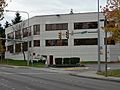
Horizon Air headquarters
-
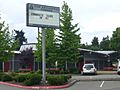
Tyee High School
-
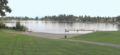
Angle Lake
See also
 In Spanish: SeaTac para niños
