Angle Lake (Washington) facts for kids
Quick facts for kids Angle Lake |
|
|---|---|

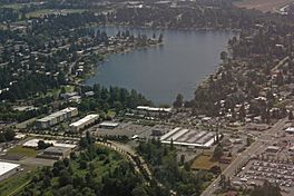
Aerial view of Angle Lake, looking from the west
|
|
| Location | SeaTac, Washington, United States |
| Coordinates | 47°25′41.11″N 122°17′8.62″W / 47.4280861°N 122.2857278°W |
| Basin countries | United States |
| Surface area | 102 acres (41 ha) |
| Max. depth | 52 ft (16 m) |
| Surface elevation | 367 ft (112 m) |
Angle Lake is a cool L-shaped lake located in SeaTac, Washington, in the United States. It covers about 102 acres, which is like 77 football fields! The lake sits between two major roads: Interstate 5 and State Route 99. It's called "Angle Lake" because of its unique shape, which looks like an angle.
On the western side of the lake, there's a fun 10-acre park called Angle Lake Park. The City of SeaTac Parks and Recreation department takes care of it. Most of the other parts of the lake's edge are surrounded by private homes.
Angle Lake is a great spot for fishing! The Washington Department of Fish and Wildlife regularly adds rainbow trout to the lake. You can also find other fish like kokanee, largemouth bass, crappie, catfish, and yellow perch. The lake is open for fishing all year long.
The Angle Lake light rail station is named after the lake. This train station is located southwest of the lake, making it easy to visit.
Angle Lake Park Fun
Angle Lake Park has been a popular place since the 1920s. You can find the park entrance off International Boulevard (Highway 99). It's only about 0.8 miles from the Seattle-Tacoma International Airport.
The park has a long shoreline, about 371 feet, where you can swim and play. There's also a special pier for fishing. If you want to have a meal outdoors, there are picnic areas ready for you. Plus, if you have a boat, there's a public boat launch to get it into the water.
 | Isaac Myers |
 | D. Hamilton Jackson |
 | A. Philip Randolph |


