Renton, Washington facts for kids
Quick facts for kids
Renton, Washington
|
||
|---|---|---|
|
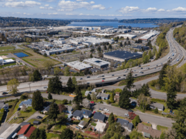
Aerial view of Renton
Renton City Hall
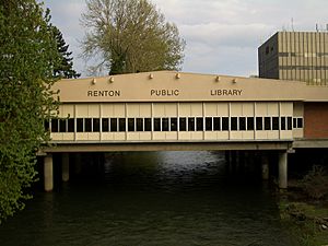
Renton Public Library
|
||
|
||
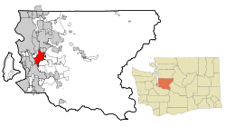
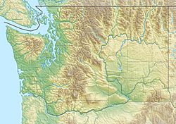
Location of Renton in King County
|
||
| Country | United States | |
| State | Washington | |
| County | King | |
| Founded | August 18, 1885 | |
| Incorporated | September 6, 1901 | |
| Government | ||
| • Type | Mayor–council | |
| Area | ||
| • City | 25.27 sq mi (65.45 km2) | |
| • Land | 23.54 sq mi (60.97 km2) | |
| • Water | 1.73 sq mi (4.47 km2) | |
| Elevation | 39 ft (12 m) | |
| Highest elevation | 558 ft (170 m) | |
| Lowest elevation | -3 ft (-0.9 m) | |
| Population
(2020)
|
||
| • City | 106,785 | |
| • Estimate
(2023)
|
104,491 | |
| • Rank | US: 310th WA: 9th |
|
| • Density | 4,439.24/sq mi (1,714.01/km2) | |
| • Urban | 3,544,011 (US: 13rd | |
| • Metro | 4,044,837 (US: 15th) | |
| Time zone | UTC−8 (Pacific (PST)) | |
| • Summer (DST) | UTC−7 (PDT) | |
| ZIP Codes |
98055, 98056, 98057, 98058, 98059
|
|
| Area code(s) | 425 | |
| FIPS code | 53-57745 | |
| GNIS feature ID | 1512599 | |
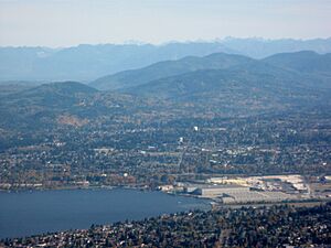
Renton is a city in Washington State, located in King County. It's like a close neighbor to Seattle, about 11 miles (18 km) southeast of its downtown area. Renton sits right on the southeast shore of Lake Washington, where the Cedar River flows into it.
In 2020, Renton had a population of 106,785 people. This was a big jump from 90,927 people in 2010. Today, it's one of the largest cities in the greater Seattle area and the 8th biggest city in Washington.
Long ago, Native Americans used the Renton area for salmon fishing. European settlers arrived in the 1860s. The city's early economy was based on coal mining, making clay products, and exporting timber.
Today, Renton is famous for being the place where Boeing builds its Boeing 737 airplanes. It's also home to many other well-known companies. These include Paccar, Kaiser Permanente, Providence Health & Services, UW Medicine, and Wizards of the Coast, which makes popular games.
Contents
History of Renton
The first European settlers in the Renton area were Henry Tobin and his wife Diana. The town grew thanks to the Seattle and Walla Walla Railroad, which was Seattle's first railway. The area had many coal mines, which attracted people like Erasmus M. Smithers. He is known for founding and establishing the town.
Smithers found coal there and brought in Charles D. Shattuck to run the mine. Renton officially became a city on September 6, 1901. At that time, coal mining and timber processing were the main industries.
Dealing with Floods
Renton used to flood often because of the Cedar and Black Rivers. In 1916, the Lake Washington Ship Canal was finished. This lowered the water level of Lake Washington by several feet. As a result, the Black River no longer drained the lake. The Cedar River was then redirected to flow into Lake Washington instead of the Black River. These changes greatly reduced the yearly flooding problem.
Growth During World War II
Renton's population grew a lot during World War II. This happened when Boeing built its Renton Factory to make the Boeing B-29 Superfortress airplane.
Modern Companies in Renton
The game company Wizards of the Coast has its main office in Renton. Providence Health System also has its main administrative offices here.
Renton is located near three major freeways: I-5, I-405, and SR 167. This makes it easy for businesses to set up shop here. Many special stores, like Fry's Electronics and IKEA, have been attracted to Renton, bringing shoppers from all over the region.
The Unique Renton Library
Renton has a very special library built right over the Cedar River. It was designed in 1964 and opened in 1966. The Renton Public Library stretches 80 feet (24 meters) across the river, next to Liberty Park.
In 2010, the library joined the King County Library system. There's a walkway in front of the library where you can watch salmon swim upstream, especially during spawning season.
In 2011, there was a big discussion about building a new library. But Renton residents wanted to keep the library in its unique river spot. They signed a petition and convinced city leaders to let people vote on it. On August 7, 2012, Renton voters decided to keep the library at the Cedar River location, with 76% of votes supporting it. The library was renovated and reopened on August 22, 2015.
Geography of Renton
Renton is located at 47°29′12″N 122°11′43″W / 47.486622°N 122.195163°W. It sits on the southeast shore of Lake Washington.
The city covers about 23.54 square miles (60.97 square kilometers). Most of this area is land, with 0.42 square miles (1.09 square kilometers) being water, mainly the Cedar River.
Renton is one of the few cities in the Puget Sound area with its own street grid system. Roads that start with "N" (like N 32nd ST) usually run east-west. Roads that end with a direction (like Duvall Ave NE) usually run north-south. Many avenues in Renton are named after other cities in Washington.
Neighboring Areas
Renton is bordered by the city of Newcastle, Washington to the north. To the east, there isn't another city right next to Renton because of the Urban Growth Boundary set by King County. This eastern border includes parts of Cougar Mountain and the community of May Valley. Further south, it rises to the East Renton Plateau before dropping to the Cedar River.
To the south, Renton borders the city of Kent, Washington. The western border includes the city of Tukwila, Washington, and the unincorporated King County community of West Hill, as well as Lake Washington to the northwest.
Climate in Renton
| Climate data for Renton, Washington | |||||||||||||
|---|---|---|---|---|---|---|---|---|---|---|---|---|---|
| Month | Jan | Feb | Mar | Apr | May | Jun | Jul | Aug | Sep | Oct | Nov | Dec | Year |
| Record high °F (°C) | 64 (18) |
71 (22) |
81 (27) |
86 (30) |
92 (33) |
100 (38) |
104 (40) |
99 (37) |
96 (36) |
86 (30) |
74 (23) |
69 (21) |
104 (40) |
| Mean daily maximum °F (°C) | 47 (8) |
51 (11) |
55 (13) |
61 (16) |
67 (19) |
72 (22) |
77 (25) |
78 (26) |
72 (22) |
62 (17) |
52 (11) |
46 (8) |
62 (17) |
| Mean daily minimum °F (°C) | 35 (2) |
36 (2) |
39 (4) |
42 (6) |
47 (8) |
52 (11) |
55 (13) |
55 (13) |
51 (11) |
44 (7) |
39 (4) |
35 (2) |
44 (7) |
| Record low °F (°C) | −10 (−23) |
−5 (−21) |
10 (−12) |
25 (−4) |
27 (−3) |
33 (1) |
38 (3) |
34 (1) |
28 (−2) |
24 (−4) |
−1 (−18) |
3 (−16) |
−10 (−23) |
| Average precipitation inches (mm) | 5.3 (130) |
4.5 (110) |
4.1 (100) |
2.9 (74) |
2.1 (53) |
1.7 (43) |
0.9 (23) |
1.2 (30) |
1.8 (46) |
3.4 (86) |
6.1 (150) |
5.8 (150) |
37.1 (940) |
| Source: Weather.com | |||||||||||||
People and Population
| Historical population | |||
|---|---|---|---|
| Census | Pop. | %± | |
| 1880 | 200 | — | |
| 1890 | 406 | 103.0% | |
| 1900 | 412 | 1.5% | |
| 1910 | 2,740 | 565.0% | |
| 1920 | 3,301 | 20.5% | |
| 1930 | 4,062 | 23.1% | |
| 1940 | 4,488 | 10.5% | |
| 1950 | 16,039 | 257.4% | |
| 1960 | 18,453 | 15.1% | |
| 1970 | 25,878 | 40.2% | |
| 1980 | 31,031 | 19.9% | |
| 1990 | 41,688 | 34.3% | |
| 2000 | 50,052 | 20.1% | |
| 2010 | 90,927 | 81.7% | |
| 2020 | 106,785 | 17.4% | |
| 2023 (est.) | 104,491 | 14.9% | |
| U.S. Decennial Census 2020 Census |
|||
In 2023, there were about 40,968 households in Renton. On average, there were 2.53 people living in each home. The typical household income was $100,237. About 7.9% of the people in Renton live below the poverty line.
About 71.7% of people in Renton have jobs. Also, 38.4% of the population has a bachelor's degree or higher. A large number, 86.2%, have a high school diploma.
The average age of people in Renton was 37.8 years.
Population by Race and Ethnicity (2020)
The 2020 census showed that Renton had 106,785 people and 42,485 households.
| Race / Ethnicity (NH = Non-Hispanic) | Pop 2000 | Pop 2010 | Pop 2020 | % 2000 | % 2010 | % 2020 |
|---|---|---|---|---|---|---|
| White alone (NH) | 32,759 | 44,937 | 42,449 | 65.45% | 49.42% | 39.75% |
| Black or African American alone (NH) | 4,142 | 9,435 | 10,585 | 8.28% | 10.38% | 9.91% |
| Native American or Alaska Native alone (NH) | 335 | 423 | 463 | 0.67% | 0.47% | 0.43% |
| Asian alone (NH) | 6,658 | 19,148 | 27,721 | 13.30% | 21.06% | 25.96% |
| Pacific Islander alone (NH) | 238 | 635 | 818 | 0.48% | 0.70% | 0.77% |
| Other race alone (NH) | 153 | 169 | 637 | 0.31% | 0.19% | 0.60% |
| Mixed Race or Multi-Racial (NH) | 1,949 | 4,233 | 7,602 | 3.89% | 4.66% | 7.12% |
| Hispanic or Latino (any race) | 3,818 | 11,947 | 16,510 | 7.63% | 13.14% | 15.46% |
| Total | 50,052 | 90,927 | 106,785 | 100.00% | 100.00% | 100.00% |
Population Details (2010)
In 2010, Renton had 90,927 people living in 36,009 households. About 32.4% of households had children under 18. About 43.2% were married couples.
The average household had 2.51 people, and the average family had 3.16 people. The median age in the city was 35.2 years. About 23.2% of residents were under 18, and 10.1% were 65 or older. The population was almost evenly split between males (49.5%) and females (50.5%).
Economy of Renton
Several major companies have their main offices in Renton. These include Boeing Commercial Airplanes, Boeing Capital, Providence Health & Services, and Wizards of the Coast.
Boeing's Presence
The Boeing Renton Factory has been operating since World War II. Back then, it made the B-29 Superfortress bombers. Today, it builds the Boeing 737 airliner. In the 1970s, the Renton plant also made Jetfoil and Pegasus class hydrofoils.
By 2001, 40% of all commercial airplanes flying around the world were put together in Renton. Boeing is still the biggest employer in Renton, with over 10,000 employees. The city was even called the "jet capital of the world" by a local newspaper in the 1970s.
Paccar's History
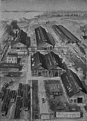
Paccar has also been a big employer in Renton for a long time. Their Kenworth Truck plant is in Renton's industrial area, near the south end of Lake Washington. In 1907, the Seattle Car Manufacturing Company moved its large factory to Renton. They made railroad equipment and were the only train car manufacturer on the west coast.
The Renton plant added foundry capabilities in 1911. In 1917, the company merged and became the Pacific Car and Foundry Company, or Paccar. During the Great Depression, the Renton Paccar plant started making power winches for the logging industry.
During World War II, the Renton factory switched to making things for the war effort. By 1945, they had built 1,500 Sherman Tanks. Later, the demand for train cars decreased. So, the Paccar Renton plant began making structural steel until the 1970s. In the early 1980s, the Paccar Railcar Division closed down. However, in 1993, a new Kenworth assembly plant opened on the same site.
Major Employers in Renton
As of 2022, these are some of the top employers in Renton:
| # | Employer | # of Employees |
|---|---|---|
| 1 | Boeing Company | 11,438 |
| 2 | Valley Medical Center | 4,749 |
| 3 | Kaiser Permanente | 3,010 |
| 4 | Renton School District No. 403 | 2,379 |
| 5 | Paccar | 1,418 |
| 6 | Kroger (Fred Meyer, QFC) | 972 |
| 7 | City of Renton | 882 |
| 8 | Providence Washington Regional Services | 860 |
| 9 | Geico Insurance | 660 |
| 10 | Renton Technical College | 532 |
| 11 | Seattle Seahawks | 523 |
| 12 | IKEA | 519 |
| 13 | Wizards of the Coast | 492 |
| 14 | Healthpoint | 446 |
| 15 | Walmart | 403 |
| 16 | Alliance Packaging | 249 |
| 17 | Bloodworks Northwest | 241 |
| 18 | Starbucks | 241 |
| 19 | Puget Sound Educational Service District | 228 |
| 20 | Target | 209 |
| 21 | Proliance Orthopedic Associates | 209 |
| 22 | AIM Aerospace | 196 |
| 23 | Trojan Litho | 188 |
| 24 | Cutter & Buck | 167 |
| 25 | Metrorcomm | 166 |
Education in Renton
Renton Technical College opened in 1942 to train people for war production. Today, it offers associate degrees and certificates in many technical fields.
The Renton School District provides public schooling from kindergarten to 12th grade. This district includes four high schools: Hazen High School, Lindbergh High School, Renton High School, and Albert Talley Senior High School. It also has four middle schools and fifteen elementary schools.
Some parts of Renton are also served by other school districts. These include the Issaquah School District, Kent School District, and the Tahoma School District. These districts mainly serve neighboring cities.
Sister Cities
Renton has two sister cities, which are cities that have a special partnership to promote cultural ties and understanding:
 Nishiwaki, Hyogo, Japan (since 1969)
 Cuautla, Jalisco, Mexico (since 2001)
Transportation in Renton
Renton has public transportation services provided by King County Metro and Sound Transit Express buses. Metro operates the RapidRide F Line through the city. Sound Transit plans to open its own bus rapid transit service, Stride, along the Interstate 405 corridor in Renton by 2026.
The city government also owns and runs the Renton Municipal Airport (KRNT), also known as Clayton Scott Field. This public airport is used by the Boeing Renton Factory. It's also used for charter services and flight training.
Notable People from Renton
Many interesting people have connections to Renton:
- Val Caniparoli, a ballet dancer and choreographer
- Jamal Crawford, a basketball player
- Joshua Farris, a figure skater, was born in Renton
- Avery Garrett, a former mayor of Renton and state legislator
- Yeimar Gómez Andrade, a professional soccer player
- Jimi Hendrix, a famous musician
- Sally Jewell, who was the 51st United States Secretary of the Interior
- Sean Kinney, the drummer for the band Alice in Chains
- Zach LaVine, a basketball player
- Sam Longoria, a Hollywood producer and director
- Rick May, a voice actor and theatrical director
- Rashaad Powell, a basketball player
- Emily Rose, an actress
- Brandon Roy, a basketball player
- Doug Sisk, a baseball player
- Aretha Thurmond, an Olympic discus thrower
- Jacob Young, an actor and producer
Images for kids
See also
 In Spanish: Renton (Washington) para niños
 | Claudette Colvin |
 | Myrlie Evers-Williams |
 | Alberta Odell Jones |


