East Renton Highlands, Washington facts for kids
Quick facts for kids
East Renton Highlands, Washington
|
|
|---|---|

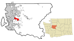
Location of East Renton Highlands, Washington
|
|
| Country | United States |
| State | Washington |
| County | King |
| Area | |
| • Total | 11.4 sq mi (29.5 km2) |
| • Land | 11.3 sq mi (29.3 km2) |
| • Water | 0.08 sq mi (0.2 km2) |
| Elevation | 525 ft (160 m) |
| Population
(2020)
|
|
| • Total | 11,937 |
| • Density | 984/sq mi (380.0/km2) |
| Time zone | UTC-8 (PST) |
| • Summer (DST) | UTC-7 (PDT) |
| FIPS code | 53-19857 |
| GNIS feature ID | 1867606 |
East Renton Highlands is a special kind of community in King County, Washington, in the United States. It's called a "census-designated place" (CDP). This means it's an area that looks like a town but isn't officially a city with its own local government. It's located between the cities of Issaquah and Renton. In 2020, about 11,937 people lived there.
Contents
History of East Renton Highlands
Over the years, people in East Renton Highlands have thought about changing how their community is governed.
Joining Renton or Becoming a New City
In 1996, the city of Renton suggested that the Maplewood Heights area, which is part of East Renton Highlands, should join Renton. However, the people living there voted against this idea.
Later, in 1998, there was another idea. Some people wanted to create a brand new city called Briarwood in the area. But this idea was also rejected by voters in an election held in March.
Recent Annexation Attempts
East Renton Highlands is considered a "potential annexation area" for Renton. This means Renton could try to include it in the future.
In February 2007, voters again said no to a plan for Renton to take over a large part of the area. About three-quarters of the voters were against it.
In 2008, the Renton City Council agreed to look at a smaller annexation plan. This plan involved a specific area of about 193 acres.
Geography of East Renton Highlands
East Renton Highlands is located at 47°28′52″N 122°7′7″W / 47.48111°N 122.11861°W. It's a beautiful area with natural features.
Location and Neighbors
To the west, East Renton Highlands is next to the city of Renton. To the east, it borders another community called Mirrormont. To the southeast, you'll find the Hobart community.
The Cedar River flows to the south of East Renton Highlands. The community is about 17 miles (27 kilometers) southeast of downtown Seattle.
Land and Water Area
The total area of East Renton Highlands is about 29.5 square kilometers (11.4 square miles). Most of this area is land, about 29.3 square kilometers (11.3 square miles). A small part, about 0.2 square kilometers (0.077 square miles), is water. This means water makes up less than 1% of the total area.
Population of East Renton Highlands
The population of East Renton Highlands has changed over the years. Here's a look at how many people have lived there during different census counts:
| Historical population | |||
|---|---|---|---|
| Census | Pop. | %± | |
| 1980 | 12,033 | — | |
| 1990 | 13,218 | 9.8% | |
| 2000 | 13,264 | 0.3% | |
| 2010 | 11,140 | −16.0% | |
| 2020 | 11,937 | 7.2% | |
| U.S. Decennial Census 2020 Census |
|||
In 2020, the population was 11,937 people.
Education in East Renton Highlands
Students in East Renton Highlands attend schools in different school districts.
Most of the community is part of the Issaquah School District. Some areas are in the Renton School District. A smaller part of the community belongs to the Tahoma School District.
See also
 In Spanish: East Renton Highlands (Washington) para niños
 | Madam C. J. Walker |
 | Janet Emerson Bashen |
 | Annie Turnbo Malone |
 | Maggie L. Walker |

