Hobart, Washington facts for kids
Quick facts for kids
Hobart, Washington
|
|
|---|---|

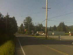
Hobart post office and general store
|
|

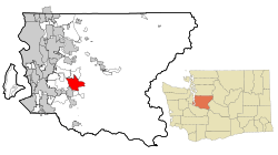
Location of Hobart, Washington
|
|
| Country | United States |
| State | Washington |
| County | King |
| Area | |
| • Total | 18.9 sq mi (49.0 km2) |
| • Land | 18.8 sq mi (48.7 km2) |
| • Water | 0.1 sq mi (0.3 km2) |
| Elevation | 568 ft (173 m) |
| Population
(2020)
|
|
| • Total | 6,767 |
| • Density | 331/sq mi (127.8/km2) |
| Time zone | UTC-8 (PST) |
| • Summer (DST) | UTC-7 (PDT) |
| ZIP code |
98025
|
| Area code(s) | 425 |
| FIPS code | 53-31495 |
| GNIS feature ID | 1520825 |
Hobart is a small place in King County, Washington, United States. It is called an unincorporated community. This means it's a town that doesn't have its own local government, like a city does. It's also a census-designated place (CDP), which means the government counts the people living there for the census. In 2020, about 6,767 people lived in Hobart.
Hobart is known as one of the wealthier areas in Washington state, based on how much money people earn there. The first people to settle in the Hobart area were loggers in 1879. They originally called the area "Vine Maple Valley". However, the Post Office thought the name was too long. So, the name was changed to Hobart. The Hobart Post Office first opened on May 9, 1903. William Sidebotham was the first postmaster. A coal mine also operated in the area until 1947.
Contents
Where is Hobart Located?
Hobart is in the middle of King County. It is located at 47.415568 degrees north and -122.005950 degrees west. To the north, you'll find Mirrormont. To the northwest is East Renton Highlands. Maple Valley is to the southwest, and Ravensdale is to the south. Taylor Mountain, which is about 2,600 feet tall, is to the northeast.
Washington State Route 18 goes through Hobart. This road leads about 9 miles northeast to Interstate 90 near Snoqualmie. It also goes about 15 miles southwest to Auburn. The big city of Seattle is about 24 miles to the northwest.
The Hobart area covers about 48.9 square kilometers (about 18.9 square miles). Most of this area is land (48.6 square kilometers or 18.8 square miles). A small part, about 0.3 square kilometers (0.1 square miles), is water. The Cedar River flows along the southern and western edges of the community.
The town of Hobart was named after Garret Augustus Hobart. He was the 24th Vice President of the United States. He served from 1897 until he passed away in 1899.
Hobart's Weather
Hobart has warm, but not very hot, and dry summers. The average monthly temperature never goes above 71.6 degrees Fahrenheit (22 degrees Celsius). This type of weather is called a warm-summer Mediterranean climate. On climate maps, it's often shown as "Csb".
How Many People Live in Hobart?
The government counts how many people live in an area every ten years. This is called a census.
| Historical population | |||
|---|---|---|---|
| Census | Pop. | %± | |
| 2000 | 6,251 | — | |
| 2010 | 6,221 | −0.5% | |
| 2020 | 6,767 | 8.8% | |
| U.S. Decennial Census 2020 Census |
|||
2020 Census Information
In the 2020 census, there were 6,767 people living in Hobart. These people lived in 2,531 different homes.
2010 Census Information
In the 2010 census, there were 6,221 people living in Hobart.
Schools in Hobart
Most of the Hobart area is part of the Tahoma School District. However, a small part of Hobart is in the Issaquah School District.
Nearby Towns and Communities
 |
Renton | Issaquah | Snoqualmie |  |
| Kent | ||||
| Maple Valley | Ravensdale |
See also
 In Spanish: Hobart (Washington) para niños
 | Janet Taylor Pickett |
 | Synthia Saint James |
 | Howardena Pindell |
 | Faith Ringgold |

