Ravensdale, Washington facts for kids
Quick facts for kids
Ravensdale, Washington
|
|
|---|---|

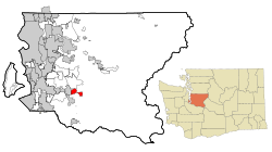
Location of Ravensdale, Washington
|
|
| Country | United States |
| State | Washington |
| County | King |
| Area | |
| • Total | 4.56 sq mi (11.82 km2) |
| • Land | 4.45 sq mi (11.52 km2) |
| • Water | 0.12 sq mi (0.30 km2) |
| Elevation | 623 ft (190 m) |
| Population
(2020)
|
|
| • Total | 555 |
| • Density | 247/sq mi (95.5/km2) |
| Time zone | UTC-8 (Pacific (PST)) |
| • Summer (DST) | UTC-7 (PDT) |
| ZIP code |
98051
|
| Area code(s) | 425 |
| FIPS code | 53-57395 |
| GNIS feature ID | 1524908 |
Ravensdale is a small community in King County, Washington, United States. It is known as a census-designated place (CDP). This means it's an area that looks like a town but isn't officially governed as one. In 2020, about 555 people lived there.
Ravensdale is a place where people earn a good income. It ranks 50th out of 522 areas in Washington state for how much money people make.
Contents
History of Ravensdale
Ravensdale was first called "Leary." This name came from the Leary Coal Company, which was named after John Leary, an early settler in Seattle. The name "Ravensdale" came later. It was inspired by the many ravens that would eat grain spilled from train cars passing through the town.
Underground coal mining started around 1899. Coal had been mined nearby a few years earlier. The Northwest Improvement Company (NWI) later took over these coal mines. NWI was part of the Northern Pacific train company.
By 1907, Ravensdale was a busy coal mining town. About 1,000 people lived there, and most worked for the mining company. Ravensdale became an official town on August 15, 1913.
A sad event happened on November 16, 1915. An explosion in the mine killed 31 men. This was one of the worst coal mining accidents in Washington state history. After this, the NWI mine closed for good. Many miners who had moved there from other countries left to find work elsewhere. Some even moved to Ray, Arizona, to mine copper. Ravensdale stopped being an official town in the 1920s.
Over the years, coal mining continued to be important for Ravensdale. New mines opened in different areas. The Dale Coal Company was very successful from 1924 to 1941. Other companies, like Continental Coal Company and Anderson Coal Company, also operated. The Palmer Coking Coal Company mined coal from 1937 to 1975.
Another accident happened on January 29, 1955. Four miners were lost in the Landsburg mine when it filled with water and mud. On December 17, 1975, the Rogers No. 3 mine was closed with dynamite. This was the very last underground coal mine in Washington state.
Geography of Ravensdale
Ravensdale is located in the southern part of King County. Its exact location is 47°21′24″N 121°58′39″W / 47.35667°N 121.97750°W. To its west is the city of Maple Valley. Ravensdale is about 28 miles (45 km) southeast of downtown Seattle. It is also the same distance northeast of Tacoma. The town sits at an elevation of about 623 feet (190 meters) above sea level.
The United States Census Bureau says that the Ravensdale CDP covers a total area of about 11.8 square kilometers (4.6 sq mi). Most of this area, about 11.3 square kilometers (4.4 sq mi), is land. The rest, about 0.3 square kilometers (0.1 sq mi), is water. Water makes up about 2.51% of the total area.
Climate
The area around Seattle and Tacoma has warm, but not hot, and dry summers. The average monthly temperature never goes above 71.6 °F (22 °C). Ravensdale has a climate known as a warm-summer Mediterranean climate. This type of climate is often called "Csb" on climate maps.
People of Ravensdale (Demographics)
| Historical population | |||
|---|---|---|---|
| Census | Pop. | %± | |
| 2000 | 816 | — | |
| 2010 | 1,101 | 34.9% | |
| 2020 | 555 | −49.6% | |
| U.S. Decennial Census 2020 Census |
|||
In 2000, there were 816 people living in Ravensdale. These people lived in 301 households, and 217 of these were families. The population density was about 162.3 people per square mile (62.6/km2). There were 321 homes, with about 63.8 homes per square mile (24.6/km2).
Most people in Ravensdale in 2000 were White (96.08%). A small number were African American, Native American, Asian, or Pacific Islander. Some people were from other races or from two or more races. About 1.23% of the population was Hispanic or Latino.
Out of the 301 households, 36.9% had children under 18 living with them. Most households (62.8%) were married couples living together. About 6.0% had a female head of household with no husband present. About 27.9% were not families. About 22.3% of all households were single people. About 5.6% of households had someone aged 65 or older living alone. The average household had 2.71 people, and the average family had 3.19 people.
The population was spread out by age. About 26.1% were under 18 years old. About 7.6% were between 18 and 24. About 27.1% were between 25 and 44. About 29.9% were between 45 and 64. And 9.3% were 65 years or older. The average age was 41 years. For every 100 females, there were about 108.2 males.
The average income for a household in Ravensdale was $44,850. For families, the average income was $61,741. Men earned about $33,182, while women earned about $30,536. The average income per person was $28,300. About 6.1% of families and 10.8% of the population earned less money than what is considered a basic living income. This included 12.7% of those under 18 and 7.8% of those 65 or older.
About 10% of Ravensdale residents aged 25 and older have a college degree.
Infrastructure
Transport
The main roads in Ravensdale are Landsburg Road, which runs north-south, and Kent Kangley Road, which runs east-west. These two roads meet near the center of town. To the west of Ravensdale, Washington State Route 169 also runs north-south near the town.
The closest airport to Ravensdale is Auburn Municipal Airport. However, this airport is only for private planes, not for commercial flights. For commercial flights, people traveling to Ravensdale use Seattle–Tacoma International Airport.
Utilities
Puget Sound Energy provides electricity to Ravensdale. This company is one of the main electricity providers for the Seattle metropolitan area.
The United States Postal Service has a post office in Ravensdale. It is located on 272nd Ave, close to Kent Kangley Road.
Notable people
- Brandi Carlile, a famous singer-songwriter, is from Ravensdale.
See also
 In Spanish: Ravensdale (Washington) para niños
 | George Robert Carruthers |
 | Patricia Bath |
 | Jan Ernst Matzeliger |
 | Alexander Miles |


