Maple Valley, Washington facts for kids
Quick facts for kids
Maple Valley, Washington
|
||
|---|---|---|

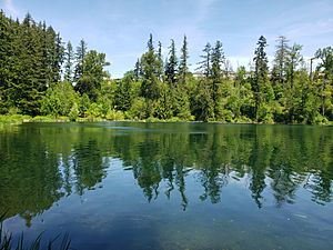
Lake Wilderness in Maple Valley
|
||
|
||

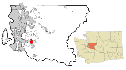
Location of Maple Valley within King County and Washington state
|
||
| Country | United States | |
| State | Washington | |
| County | King | |
| Settled | 1879 | |
| Incorporated | August 31, 1997 | |
| Government | ||
| • Type | Council–manager | |
| Area | ||
| • Total | 6.18 sq mi (16.02 km2) | |
| • Land | 6.00 sq mi (15.55 km2) | |
| • Water | 0.18 sq mi (0.47 km2) | |
| Elevation | 420 ft (128 m) | |
| Population
(2020)
|
||
| • Total | 28,013 | |
| • Estimate
(2023)
|
28,434 | |
| • Density | 4,734/sq mi (1,828/km2) | |
| Time zone | UTC–8 (Pacific (PST)) | |
| • Summer (DST) | UTC–7 (PDT) | |
| ZIP Code |
98038
|
|
| Area code(s) | 425 | |
| FIPS code | 53-43150 | |
| GNIS feature ID | 1506457 | |
Maple Valley is a city located in King County, Washington, in the United States. In 2020, about 28,013 people lived there. Many people who live in Maple Valley travel to other cities for work. However, more and more businesses are opening up in the area.
Contents
History of Maple Valley
Early Settlement and Growth
Maple Valley was first settled in 1879. Three men arrived, improved a trail, and then brought their families to live there. When it was time to name the new community, people suggested "Vine Maple Valley" and "Maple Ridge." They voted by writing names on slips of paper and putting them in a hat. "Vine Maple Valley" won, but the post office later shortened it to "Maple Valley" because the name was too long.
The town's early days were all about coal mining, cutting lumber for homes, and the railroad. Coal was brought in from nearby Black Diamond. Maple Valley also had its own coal mine on Cedar Mountain, which was used until 1947. More workers came for the railroads and the Cedar River Watershed. This led to more lumber mills, which brought even more workers. Suquamish tribe chairperson Martha George was born near Maple Valley in 1892. Her mother and grandmother worked as cooks at a logging camp there.
Developing the Town Center
By the 1910s and 1920s, Maple Valley had blacksmith shops, hotels, saloons, and stores. Schools were also built. The first schools were simple shacks. A two-room school opened in 1910. A larger high school was built in 1929. This was the first high school in the Tahoma School District. After many updates, this building is still used today as an elementary school. Much of this early growth actually happened in Hobart, which is northeast of where Maple Valley is now.
Farming, Fishing, and Resorts
As more people moved to the area, farming and fishing became important. People farmed milk, poultry, and berries. Fishing in the Cedar River was also popular. In the 1920s, resorts started to appear in Maple Valley. Lake Wilderness, which used to be a lumber mill site, became a popular resort lake. Gaffney's Grove opened with a ballroom, restaurant, and roller rink. Later, it added an airstrip, cabins, a golf course, and a bowling alley. The resort stayed open until 1964.
Modern Roads and History Preservation
In the early 1960s, more cars meant new roads were needed. State Route 18 was built through the city, connecting Auburn and North Bend. This road required many old buildings to be torn down or moved. The Maple Valley Historical Society works to save the city's past. They have two museums with old items, like the city's first fire engine, and photos of places like Gaffney's Grove.
Becoming an Official City
Maple Valley officially became a city on August 31, 1997. The Green to Cedar River trail now runs through the city. It follows SR 169 and Witte Road. The trail passes through the old Gaffney's Grove site, which is now Lake Wilderness City Park. This park has a swimming beach and large grassy areas. The annual Maple Valley Days Parade happens here every June. The Lake Wilderness Arboretum is also in this park.
Maple Valley is divided into different areas by Maple Valley Black Diamond Road (SR 169). This is the main road through the city. At the north and south ends of the city are two large shopping areas. The middle part of Maple Valley is mostly homes.
The Four Corners district on the south side is the main shopping area. It is located along Maple Valley Black Diamond Road and is split by Kent Kangley Road (SR 516). This creates four distinct areas. The northwest corner was rebuilt in the early 2010s and now has big stores, apartments, and a strip mall. The northeast corner was built in the 2010s. It used to be a large lumberyard and now has many stores. The southern corners have strip malls, stores, apartments, and housing.
Geography of Maple Valley
Maple Valley is located at 47°23′34″N 122°02′47″W / 47.39278°N 122.04639°W. The city covers about 6.18 square miles (16.02 square kilometers). Most of this area is land (6.00 sq mi or 15.55 sq km), and a small part is water (0.18 sq mi or 0.47 sq km).
The main bodies of water inside the city are Lake Wilderness, Lake Lucerne, Rock Creek, and part of Pipe Lake. The Cedar River flows very close to the city's northeastern border, but it's in an area outside the city limits. Maple Valley is next to Hobart, Fairwood, and Ravensdale. It also borders the cities of Covington, Renton, Kent, and Black Diamond.
Climate in Maple Valley
Maple Valley has a climate that is like a Mediterranean or maritime climate. This means it generally has cooler nights and more rain than Seattle throughout the year. Winter days are also a bit colder than areas closer to downtown Seattle.
| Climate data for Landsburg, Washington, (1991–2020 normals, extremes 1915–present) | |||||||||||||
|---|---|---|---|---|---|---|---|---|---|---|---|---|---|
| Month | Jan | Feb | Mar | Apr | May | Jun | Jul | Aug | Sep | Oct | Nov | Dec | Year |
| Record high °F (°C) | 68 (20) |
74 (23) |
84 (29) |
89 (32) |
102 (39) |
112 (44) |
101 (38) |
102 (39) |
97 (36) |
88 (31) |
76 (24) |
72 (22) |
112 (44) |
| Mean maximum °F (°C) | 55.9 (13.3) |
58.9 (14.9) |
66.8 (19.3) |
75.3 (24.1) |
83.8 (28.8) |
86.8 (30.4) |
92.1 (33.4) |
90.9 (32.7) |
84.8 (29.3) |
72.1 (22.3) |
59.6 (15.3) |
53.8 (12.1) |
95.3 (35.2) |
| Mean daily maximum °F (°C) | 45.7 (7.6) |
48.9 (9.4) |
53.3 (11.8) |
58.6 (14.8) |
65.9 (18.8) |
70.3 (21.3) |
77.0 (25.0) |
77.3 (25.2) |
70.6 (21.4) |
59.5 (15.3) |
49.9 (9.9) |
44.5 (6.9) |
60.1 (15.6) |
| Daily mean °F (°C) | 39.3 (4.1) |
40.9 (4.9) |
44.0 (6.7) |
48.5 (9.2) |
54.9 (12.7) |
59.2 (15.1) |
64.2 (17.9) |
64.4 (18.0) |
58.8 (14.9) |
50.3 (10.2) |
42.8 (6.0) |
38.4 (3.6) |
50.5 (10.3) |
| Mean daily minimum °F (°C) | 33.0 (0.6) |
32.8 (0.4) |
34.7 (1.5) |
38.5 (3.6) |
43.9 (6.6) |
48.2 (9.0) |
51.4 (10.8) |
51.5 (10.8) |
46.9 (8.3) |
41.2 (5.1) |
35.7 (2.1) |
32.3 (0.2) |
40.8 (4.9) |
| Mean minimum °F (°C) | 22.1 (−5.5) |
22.7 (−5.2) |
25.7 (−3.5) |
29.3 (−1.5) |
34.1 (1.2) |
39.9 (4.4) |
43.0 (6.1) |
43.0 (6.1) |
37.9 (3.3) |
29.8 (−1.2) |
24.7 (−4.1) |
20.8 (−6.2) |
17.0 (−8.3) |
| Record low °F (°C) | 1 (−17) |
0 (−18) |
12 (−11) |
23 (−5) |
25 (−4) |
31 (−1) |
33 (1) |
29 (−2) |
28 (−2) |
17 (−8) |
4 (−16) |
0 (−18) |
0 (−18) |
| Average precipitation inches (mm) | 7.99 (203) |
5.44 (138) |
6.19 (157) |
5.55 (141) |
3.87 (98) |
3.15 (80) |
1.29 (33) |
1.64 (42) |
2.83 (72) |
5.76 (146) |
8.51 (216) |
7.46 (189) |
59.68 (1,515) |
| Average precipitation days (≥ 0.01 inch) | 19.9 | 17.5 | 20.1 | 18.6 | 15.0 | 12.4 | 6.8 | 6.6 | 10.0 | 16.9 | 21.0 | 20.8 | 185.6 |
| Source 1: NOAA | |||||||||||||
| Source 2: National Weather Service | |||||||||||||
People in Maple Valley
Population Growth
| Historical population | |||
|---|---|---|---|
| Census | Pop. | %± | |
| 1990 | 1,211 | — | |
| 2000 | 14,209 | 1,073.3% | |
| 2010 | 22,684 | 59.6% | |
| 2020 | 28,013 | 23.5% | |
| 2023 (est.) | 28,434 | 25.3% | |
| U.S. Decennial Census 2020 Census |
|||
Maple Valley is one of the fastest-growing areas in Washington State. Between 2000 and 2010, the city's population grew by almost 63%. This made it the 17th fastest-growing city in the state during that time. According to the 2020 census, the population was 28,013. The city is currently the 41st largest city out of 281 cities in Washington State.
Education and Income
A high number of adults in Maple Valley have gone to college, about 75%. The average household income in Maple Valley was $117,706 in 2020. Because people earn good money and housing costs are not as high as in some other places, residents often have more money to spend.
Diversity in Maple Valley
As of the 2020 census, there were 28,013 people living in Maple Valley.
- About 70.7% of people were White (not Hispanic or Latino).
- About 8.8% were Asian (not Hispanic or Latino).
- About 8.6% were of two or more races (not Hispanic or Latino).
- About 8.0% of the population was Hispanic or Latino (who can be of any race).
- Smaller percentages were Black or African American, Native American, or Pacific Islander.
Education in Maple Valley
All of Maple Valley is served by the Tahoma School District. The district has one high school, two middle schools, and six elementary schools. The district's transportation center is located near SR 18. The main office building is next to Rock Creek Elementary School.
The Tahoma School District used to have its high school in Covington. In 2015, people voted to build a new high school that would be more central. It was built in a small area surrounded by Maple Valley, sometimes called the 'Donut Hole'. This area was then made part of Maple Valley. The new three-story Tahoma High School was finished in 2017.
Most of the schools in the district are located within Maple Valley. Here are some of them:
- Tahoma High School (Maple Valley)
- Maple View Middle School (Covington)
- Summit Trail Middle School (Ravensdale)
- Glacier Park Elementary School (Maple Valley)
- Rock Creek Elementary School (Maple Valley)
- Shadow Lake Elementary School (Maple Valley)
- Cedar River Elementary School (Maple Valley)
- Lake Wilderness Elementary School (Maple Valley)
- Tahoma Elementary School (Hobart)
Fun Places to Visit
- Cedar River
- Cedar River Trail
- Lake Wilderness
- Lake Wilderness Lodge
- Lake Wilderness Arboretum
- Walsh Lake
Famous People from Maple Valley
- Darby Allin, a professional wrestler
- Brandi Carlile, a singer and songwriter
- Zan Fiskum, a singer who was on a reality show
- Omare Lowe, a former NFL football player
- Jens Pulver, a UFC fighter and coach
- Richard Sherman, an NFL cornerback who played for the Seattle Seahawks, San Francisco 49ers, and Tampa Bay Buccaneers
- Johnny Valentine, a professional wrestler inducted into the Hall of Fame in 2006
See also
 In Spanish: Maple Valley (Washington) para niños
 | Janet Taylor Pickett |
 | Synthia Saint James |
 | Howardena Pindell |
 | Faith Ringgold |


