Fairwood, King County, Washington facts for kids
Quick facts for kids
Fairwood, Washington
|
|
|---|---|

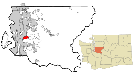
Location of Fairwood, Washington
|
|
| Country | United States |
| State | Washington |
| County | King |
| Area | |
| • Total | 4.86 sq mi (12.60 km2) |
| • Land | 4.86 sq mi (12.60 km2) |
| • Water | 0 sq mi (0.0 km2) |
| Elevation | 500 ft (200 m) |
| Population
(2020)
|
|
| • Total | 19,396 |
| • Density | 3,986.9/sq mi (1,539.4/km2) |
| Time zone | UTC-8 (Pacific (PST)) |
| • Summer (DST) | UTC-7 (PDT) |
| FIPS code | 53-23160 |
| GNIS feature ID | 2407983 |
Fairwood is a community in King County, Washington, United States. It is not an official city but is a "census-designated place" (CDP). This means it is a special area the government uses for counting people.
As of the 2020 census, about 19,396 people live in Fairwood.
Contents
Fairwood's Location
Fairwood is located at 47°26′49″N 122°08′37″W / 47.44694°N 122.14361°W. It is about 16 miles southeast of downtown Seattle.
The Fairwood area is next to the city of Renton on its north and west sides. To the east, it borders the Maple Heights-Lake Desire area. Both Fairwood and Maple Heights-Lake Desire share the same ZIP Code (98058) with Renton.
The area of Fairwood is about 12.6 square kilometers (or 4.9 square miles).
Fairwood sits on a flat, raised area of land called a plateau. This plateau stretches from the Cedar River valley in the north down towards State Route 167 in the west.
Where is Fairwood?
 |
Renton | East Renton Highlands | Issaquah |  |
| Renton/Kent | Hobart | |||
| Kent | Covington | Maple Valley |
Parks and Fun in Fairwood
Fairwood has several great parks and places for outdoor activities.
- Fairwood Golf & Country Club – This is a large golf course with 18 holes. It also has a heated swimming pool and a fitness gym.
- Petrovitsky Park – This big park is 88 acres. It has four baseball fields, soccer fields, a playground, and picnic areas.
Other fun places near Fairwood include:
- Spring Lake / Lake Desire Park – This park is east of Fairwood. It has an 11-mile trail for hiking, horseback riding, and mountain biking.
- Soos Creek Trail and Park – Located in western Fairwood, this area is great for watching birds like ducks and raptors. The 12-mile Soos Creek trail was extended to Fairwood a few years ago.
- McGarvey Park – This park has a 1.2-mile hiking trail up Cedar Mountain. You can see Mount Rainier from the top of Cedar Mountain.
- Cedar River Trail – This trail follows the Cedar River from Renton to Maple Valley.
Schools in Fairwood
Students in Fairwood attend schools in two different school districts: the Renton and Kent districts. Some parts of the Fairwood ZIP code area are also served by the Tahoma School District.
Here are some of the schools that serve the Fairwood area:
High Schools
- Lindbergh High School
- Kentridge High School
Middle Schools
- Nelsen Middle School
- Meeker Middle School
- Northwood Middle School
Elementary Schools
- Renton Park ES
- Carriage Crest ES
- Cascade Elementary
- Fairwood ES
- Glenridge ES
- Lake Youngs ES
- Ridgewood ES
- Springbrook ES
- Shadow Lake Elementary
- Benson Hill ES
Main Roads in Fairwood
Fairwood has three main roads that help people get around.
- Petrovitsky Road runs east to west through the main part of Fairwood. Many Fairwood residents work at the Boeing Renton Factory nearby.
- 140th Avenue runs north to south. It goes past the Fairwood shopping centers and Soos Creek.
- State Route 169 (also called Maple Valley Highway) is on the northern edge of Fairwood. It provides quick access to Interstate 405.
Safety in Fairwood
Fire protection and emergency medical services in Fairwood are provided by Fire Districts 40 and 37. The main fire station for District 40 is on Petrovitsky Road. The King County Sheriff helps keep the area safe by providing police services.
Fairwood's Population
| Historical population | |||
|---|---|---|---|
| Census | Pop. | %± | |
| 2010 | 19,102 | — | |
| 2020 | 19,396 | 1.5% | |
| US Decennial Census | |||
2020 Population Count
In 2020, there were 19,396 people living in Fairwood. There were 6,970 households and 7,338 housing units.
The population included:
- 136 American Indian/Alaska Native people
- 4,106 Asian people
- 1,559 Black/African American people
- 163 Native Hawaiian/Other Pacific Islander people
- 10,437 White people
- 731 people of some other race
- 2,264 people of two or more races
About 1,757 people were of Hispanic/Latino background.
2010 Population Count
In 2010, there were 19,102 people living in Fairwood. The population density was about 3,927 people per square mile.
- 65.3% of the people were White.
- 7.4% were African American.
- 17.6% were Asian.
- 6.5% were Hispanic or Latino.
About 24.6% of the population was under 18 years old. The average age was 38.3 years.
Fairwood's Economy
More people in Fairwood have jobs compared to the rest of King County. The average household income in Fairwood is about $85,000, which is higher than the county average.
Many people who live in Fairwood work in the southern part of King County. Their commute to work is usually less than 30 minutes. A large number of workers in Fairwood (about 70%) have jobs in professional fields, management, and sales.
See also
 In Spanish: Cascade-Fairwood (Washington) para niños
 | Misty Copeland |
 | Raven Wilkinson |
 | Debra Austin |
 | Aesha Ash |

