
Westport, Washington facts for kids
Quick facts for kids
Westport, Washington
|
|
|---|---|

The marina district of Westport, looking east from the Westport Viewing Tower
|
|
| Nickname(s):
Salmon Capital of the World
|
|

Location of Westport, Washington
|
|
| Country | United States |
| State | Washington |
| County | Grays Harbor |
| Founded | 1857 |
| Incorporated | June 26, 1914 |
| Government | |
| • Type | Mayor–council |
| Area | |
| • Total | 5.94 sq mi (15.38 km2) |
| • Land | 3.69 sq mi (9.56 km2) |
| • Water | 2.25 sq mi (5.83 km2) |
| Elevation | 23 ft (7 m) |
| Population
(2020)
|
|
| • Total | 2,213 |
| • Density | 569.11/sq mi (219.76/km2) |
| Demonym(s) | Westportarican |
| Time zone | UTC-8 (Pacific (PST)) |
| • Summer (DST) | UTC-7 (PDT) |
| ZIP code |
98595
|
| Area code(s) | 360 |
| FIPS code | 53-77630 |
| GNIS feature ID | 1531536 |
Westport is a city in Grays Harbor County, Washington, United States. It is located on a peninsula where the Grays Harbor meets the Pacific Ocean. In 2020, about 2,213 people lived there.
Westport is famous for its large public marina. This marina is the biggest on the outer coast of the Pacific Northwest in the United States. Many commercial fishing boats use the marina, along with boats for fun fishing trips. Westport also hosts the Washington Tuna Classic, a big fishing event every August.
Contents
History of Westport
Westport became an official city on June 26, 1914. Before that, it had other names like Peterson's Point and Chehalis City. One old name was Fort Chehalis, from a U.S. Army fort built in 1860.
The word "ts-a-lis" in the Lower Chehalis language means "place of sand." Early explorers said this word as "Chehalis," and it became the name for the river and the people living there. Native American tribes, like the Shoalwater Bay Tribe, used this area regularly in the summer. The first known settler, Thomas Barker Speake, arrived with his family in 1857. Westport is also home to a station for the United States Coast Guard.
Tsunami Safety Buildings
In 2016, the Ocosta School District built something very special. They created the first public vertical tsunami shelter in North America. This shelter is at Ocosta Elementary School. It is about 53 feet (16 meters) tall and is connected to the school. It can hold 1,000 people and is built to survive a strong earthquake from the Cascadia subduction zone. This important project cost $13.8 million and was paid for by local money.
Westport is also getting a new community tsunami evacuation tower. In 2023, the city received a $15.2 million grant for this project. The tower will be about 50 feet (15 meters) tall and can also hold 1,000 people. It is planned to be part of a park near the marina and should be ready by 2026. Westport also received $2.0 million to build a communication network that will work even during a big disaster. The city hopes to add three more towers in the future.
Geography and Climate
Westport is the westernmost place named "Westport" in the world! The next closest one is in Westport, California, which is a little bit to the east.
The city covers about 4.50 square miles (11.65 square kilometers). Most of this area, about 3.70 square miles (9.58 square kilometers), is land. The rest, about 0.80 square miles (2.07 square kilometers), is water.
The weather in Westport is usually mild and wet. From November to January, there is a lot of rain, often more than 10 inches (250 mm) each month. It rarely snows in Westport.
Population of Westport
Westport has grown quite a bit over the years.
| Historical population | |||
|---|---|---|---|
| Census | Pop. | %± | |
| 1920 | 114 | — | |
| 1930 | 272 | 138.6% | |
| 1940 | 443 | 62.9% | |
| 1950 | 731 | 65.0% | |
| 1960 | 976 | 33.5% | |
| 1970 | 1,364 | 39.8% | |
| 1980 | 1,954 | 43.3% | |
| 1990 | 1,892 | −3.2% | |
| 2000 | 2,137 | 12.9% | |
| 2010 | 2,099 | −1.8% | |
| 2020 | 2,213 | 5.4% | |
| U.S. Decennial Census 2020 Census |
|||
In 2010, there were 2,099 people living in Westport. About 87% of the people were White. There were also people from other backgrounds, including African American, Native American, and Asian. About 7.3% of the population was Hispanic or Latino. The average age of people in Westport was 48.4 years.
Westport's Economy
The Westport Marina is one of the best commercial fishing ports in the United States every year. In the past, Westport was known for its logging industry. Today, cranberry farming is also a steady part of the area's economy.
Recently, Westport has been focusing more on tourism. This includes activities like surfing and enjoying the fresh seafood available locally. This change has helped the city's businesses grow, especially after the Covid-19 pandemic.
Gallery
-
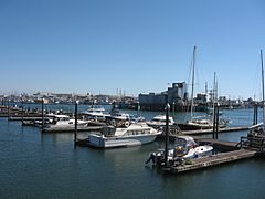
Marina at Westport, Washington
-
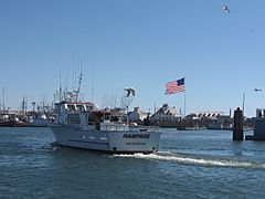
A typical fishing boat returning to the Westport Marina
-
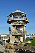
The observation tower at Westport


See also
 In Spanish: Westport (Washington) para niños
