
Crater Glacier facts for kids
Quick facts for kids Crater Glacier |
|
|---|---|

The Crater Glacier from the north in October 2006
|
|
| Type | Mountain Glacier |
| Location | Mount St. Helens, Skamania County, Washington, USA |
| Coordinates | 46°11′48″N 122°11′15″W / 46.19667°N 122.18750°W |
| Thickness | Ranges up to 656 ft (200 m) |
| Terminus | Talus |
| Status | Expanding |
The Crater Glacier is a young glacier found on Mount St. Helens in Washington, USA. It started forming after the huge 1980 eruption. Because of where it is, inside the volcano's crater, it grew very quickly. For almost 20 years, most people didn't even know it existed!
Before the volcanic activity from 2004 to 2008, the glacier had smooth ice with cool ice caves. But the new lava domes and eruptions changed how the glacier looked. During this time, the glacier got its official name, Crater Glacier, after some discussion. Even with the volcano rumbling, the glacier kept growing. By mid-2008, it completely surrounded the lava domes. New smaller glaciers have also started to form around it.
Contents
What is Crater Glacier?
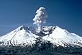
True to its name, this glacier sits inside the bowl-shaped crater that was left by the 1980 eruption of Mount St. Helens. It's about 6,794 feet (2,071 meters) high. A big lava dome, which formed between 1980 and 1987, is in the middle of the crater. The glacier grew in a horseshoe shape around this dome.
How it Grew So Fast
The glacier grew super fast for a few reasons:
- Lots of snowfall in winter.
- Many snow avalanches.
- Rockfalls from the crater walls.
- The tall cliffs around it blocked the sun, keeping it cool.
Because of all the rockfalls, the glacier is about 60% ice and 40% rock. It's usually about 328 feet (100 meters) thick, but can be as deep as 656 feet (200 meters). None of its ice is older than 1980. By 2001, this new glacier was almost half the size of all the glaciers on Mount St. Helens before the 1980 eruption!
In summer, the glacier looks dark and dirty. This is from all the rocks falling off the steep crater walls and ash from eruptions. This dirt actually helps the glacier by insulating it and protecting it from melting.
Changes from 2004-2008 Eruptions
The volcanic activity from 2004 to 2008 created new domes that almost split the glacier into two parts at the south end of the crater. But even with four years of lava dome building, Crater Glacier is still North America's youngest and fastest-growing glacier. In May 2008, the two parts of the glacier joined up at the north end, completely surrounding the lava domes. Melted water from the glacier forms Loowit Creek.
Glacier Caves

In 2000, scientists found cool glacier caves on the glacier's surface. Many of these caves were big enough to explore! Most of them were near the 1980s lava dome. Hot steam and gases from hidden vents (called fumaroles) melted holes in the ice. About 7,900 feet (2.4 kilometers) of these caves and tunnels were mapped and studied.
New Glaciers Forming
Since 2004, new glaciers have started to form on the crater walls above Crater Glacier. These new glaciers feed rock and ice down to Crater Glacier. There are also two rock glaciers (which are mostly rock with some ice) to the north of Crater Glacier. Some of these rock glaciers have even joined up with Crater Glacier.
How Crater Glacier Grew
After the eruption, the crater floor was very hot and unstable. There were small eruptions and lava dome building until late 1980. Once the eruptions stopped, the crater floor cooled enough for snow and ice to build up.
Early Growth
Starting in the winter of 1980-1981, the glacier began to grow very quickly in the shadow of the crater. It got thicker by as much as 50 feet (15 meters) each year! It also moved northward by up to 135 feet (41 meters) a year. Scientists discovered this growth about seven to nine years later, but the public didn't know about the glacier until 1999.
By 2004, Crater Glacier covered about 0.36 square miles (0.93 square kilometers). This was about 20% of the total area of all the glaciers on Mount St. Helens before 1980. It had two main parts, or "lobes," flowing around the 1980s lava dome. Because of the gases coming from the crater floor, there were glacier caves in the ice, and some of them were explored in the late 1990s.
Impact of 2004-2008 Eruptions

During the volcanic activity from 2004 to 2008, the growing lava domes pushed the glacier's ice aside. This squeezed the ice between the crater wall and the new lava domes, making it move very fast downhill, like toothpaste being squeezed from a tube! This caused the glacier to advance quickly. First, the western part of the glacier joined with a rock glacier on the western crater wall. Then, both parts of Crater Glacier joined north of the 1980s lava dome in May 2008, even with the volcano erupting.
The eruptions also changed the glacier's surface. It went from being mostly smooth to a jumbled mess of broken ice and deep cracks (called crevasses). This happened because the crater floor was moving and new lava domes were growing. At the south end, the new domes almost split Crater Glacier into two separate glaciers and melted about 10% of its ice. However, cold rock at the edge of the glacier helped protect the ice from the very hot lava (about 1,300°F or 700°C). This helped prevent a huge mudflow (called a lahar) that could have happened if too much ice melted quickly.
Current State
After the volcanic activity of the 2000s, the glacier continues to get thicker, though at a slower rate of about 15 feet (4.6 meters) per year. It also keeps moving forward by about 3 feet (1 meter) each day. Pictures from 2012 show that the glacier has moved into the upper part of the Loowit Creek canyon. Ice mixed with rocks now spills into the canyon, pushing the creek to the east. On the eastern crater wall, the glacier touches one of the rock glaciers and is very close to joining another. You can also see a line of rock and debris (a medial moraine) where the eastern and western parts of Crater Glacier meet.
Glacier Evolution in the Caldera
-
October 1980: The crater floor was active and unstable after the May 1980 eruption, before Crater Glacier started to form.
-
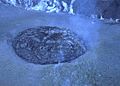
May 1982: You can see snow building up from avalanches off the crater walls (behind the steaming 1980s lava dome, zoom in to view).
-
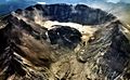
October 2000: Crater Glacier from the north, before the 2004-2008 eruptions began.
-
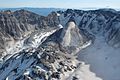
February 2005: The Crater Glacier was almost split at its south end by the new lava domes. You can see the eastern part of the glacier getting thicker and squeezed.
-
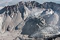
October 2006: Glaciers in the crater of Mount St. Helens. Crater Glacier is shaped like a horseshoe around the new domes. The west part of the glacier is visible at the bottom right, and two more rock glaciers are to the left of the east part.


.jpg)

Naming the Glacier
When scientists first saw the glacier forming in the late 1980s, they informally called it the "crater glacier." This name was commonly used by the public and in many scientific papers for about two decades.
In late 2004, after the new eruptions started, people decided it was time to give the glacier an official name. Someone from the Cowlitz tribe suggested "Tulutson Glacier," which means "ice" in their language. In March 2005, a state board in Washington chose Tulutson.
However, the U.S. Board on Geographic Names had the final say for the whole country. They considered "Tulutson Glacier," "Crater Glacier," and "Kraffts Glacier" (named after two volcanologists). In June 2006, the U.S. Board chose Crater Glacier. They picked this name because it had been commonly used for 20 years. Even though the state of Washington preferred Tulutson, Crater Glacier became the official name.
