Lituya Bay facts for kids
Quick facts for kids Lituya Bay |
|
|---|---|

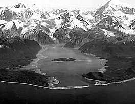
Oblique aerial photograph of Lituya Bay in the summer of 1958. Damage from the 1958 megatsunami appears as the lighter-colored areas on the shores where trees have been stripped away.
|
|
| Location | North Pacific Ocean |
| Coordinates | 58°38′13″N 137°34′23″W / 58.63694°N 137.57306°W |
| River sources |
|
| Basin countries | United States |
| Max. length | 14.5 km (9 mi) |
| Max. width | 3.2 km (2 mi) |
Lituya Bay is a long, narrow bay (called a fjord) in southeastern Alaska, a state in the United States. Its name comes from the Tlingit language and means 'lake within the point'. The bay is about 14.5 kilometers (9 miles) long and 3.2 kilometers (2 miles) wide. A French explorer named Jean-François de Lapérouse found the bay in 1786. He called it Port des Français. Sadly, 21 of his men died there because of strong ocean currents.
About Lituya Bay
Lituya Bay is part of Glacier Bay National Park and Preserve. Several large glaciers flow into the bay. These include the smaller Cascade and Crillon glaciers, and the much larger Lituya Glacier.
In the middle of the bay, you can find Cenotaph Island. The entrance to the bay is about 500 meters (0.3 miles) wide. It has a narrow channel that ships can use.
Strong Tides and Currents
Lituya Bay is known for its very strong tides. The water level can change by about 3 meters (10 feet) between high and low tide. The currents at the bay's entrance can reach speeds of 9.4 kilometers per hour (5.1 knots). This makes the entrance dangerous for boats, especially when the tides are changing. However, once inside, the bay offers a safe place for ships to anchor.
Famous Tsunamis
Lituya Bay is also famous for four huge waves, called tsunamis, that have been recorded there. These happened in 1854, 1899, 1936, and 1958.
The bay is even mentioned in a short story by Jack London called "The Unexpected." In that story, the bay's name is spelled "Latuya."
The 1958 Megatsunami
The shape of Lituya Bay, which causes its strong tides, also led to the biggest wave ever recorded. This wave, called a megatsunami, ran up a hillside higher than any other known wave.
On the night of July 9, 1958, a powerful earthquake shook the area. This earthquake caused a huge landslide in Gilbert Inlet, at the very end of the bay. The landslide created a massive megatsunami. This giant wave was so powerful that it rushed up the opposite hillside to an amazing height of 1,719 feet (524 meters). This is taller than the Empire State Building!
There were three fishing boats anchored near the bay's entrance when the giant wave happened.
- One boat, named the Sunmore, tried to leave the bay but was sunk by the wave and floating debris.
- The second boat, the Badger, was carried over a sandbar and into the ocean. It was hit by a floating log and sank. However, the married couple on board, the Swansons, managed to get into a small boat and were later rescued.
- The third boat, the Edrie, was anchored on the other side of the bay entrance. The father, Howard Ulrich, turned his boat to face the wave. The wave lifted the Edrie high above the trees, breaking its anchor chain. But then, it washed the boat back into the bay with only minor damage.
William A. Swanson and Howard G. Ulrich were eyewitnesses to this incredible event. They shared what they saw. Based on Swanson's description of how long it took the wave to reach his boat, the wave might have been traveling at 120 miles per hour (193 km/h). However, once it reached the open ocean, it quickly lost its power. This event was the first time people had direct proof and eyewitness accounts of a megatsunami.
See also
 In Spanish: Bahía Lituya para niños
 | James B. Knighten |
 | Azellia White |
 | Willa Brown |


