Lituya Glacier facts for kids
Quick facts for kids Lituya Glacier |
|
|---|---|

Lituya Glacier
|
|
| Type | Tidewater glacier |
| Coordinates | 58°43′25″N 137°29′33″W / 58.72361°N 137.49250°W |
| Length | 11 miles (18 km) |
| Terminus | Ocean (Lituya Bay) |
| Status | Retreating |
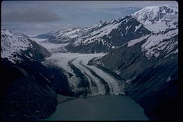
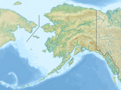
The Lituya Glacier is a large glacier located in Alaska, a state in the U.S.. It is found within the beautiful Glacier Bay National Park and Preserve. This glacier starts high up in the Fairweather Range mountains. From there, it slowly moves down and eventually flows into Lituya Bay. Lituya Bay is a narrow inlet that connects to the Gulf of Alaska.
How Lituya Glacier Shaped the Bay
Lituya Glacier played a big role in forming Lituya Bay. Over many, many years, the glacier slowly carved out the land. It created a unique bay with very steep sides. The bottom of the bay is also very deep underwater. The entrance to the ocean from Lituya Bay is very narrow.
This special shape, created by the glacier, was important for a huge event. In 1958, a massive megatsunami happened in Lituya Bay. A megatsunami is a giant wave, much bigger than a regular tsunami. The way the glacier shaped the bay helped make this huge wave possible.
Lituya Glacier's Namesake Ferry
The Lituya Glacier is also famous for something else. An Alaska Marine Highway ferry boat is named after it. This ferry is called the M/V Lituya. It helps people travel along the coast of Alaska.
See also
 In Spanish: Glaciar Lituya para niños
 | Laphonza Butler |
 | Daisy Bates |
 | Elizabeth Piper Ensley |


