Lituya Mountain facts for kids
Quick facts for kids Lituya Mountain |
|
|---|---|

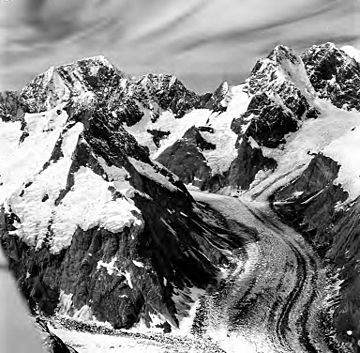
Lituya (upper left) and Mt. Salisbury (right)
|
|
| Highest point | |
| Elevation | 11,924 ft (3,634 m) |
| Prominence | 3,624 ft (1,105 m) |
| Geography | |
| Parent range | Fairweather Range |
| Topo map | USGS Mount Fairweather D-5 |
| Climbing | |
| First ascent | 1962 by S. Arighi, D. Bohn, D. Chappelear, H. Flachsmann, A. Maki, M. Mushkin and L. Nielsen |
| Easiest route | Glacier / snow / ice climb |
Lituya Mountain is a tall peak in Alaska, United States. It is part of the Fairweather Range of mountains. This mountain is known for its amazing views and for being near some very active glaciers. It also has a history of huge natural events, like giant waves and massive landslides.
The eastern side of Lituya Mountain feeds into a part of the Johns Hopkins Glacier. This glacier then flows into Glacier Bay. On its western side, there is a large bowl-shaped area called a cirque. This cirque is shared with other mountains like Mount Fairweather and Mount Salisbury. It is where the Fairweather Glacier begins, which flows almost to the Pacific Ocean. Another glacier, the Lituya Glacier, flows from the south side of the mountain into Lituya Bay on the Pacific coast.
About Lituya Mountain
Lituya Mountain is not the highest mountain around, but it rises very sharply from the land around it. For example, the south side of the mountain drops about 8,000 feet (2,400 meters) down to the Lituya Glacier in just 3 miles (4.8 kilometers). The southeast side drops the same distance in a little over 2 miles (3.2 kilometers). This makes it look very dramatic.
People do not climb Lituya Mountain very often. One reason is that Mount Fairweather is nearby, which is taller and more famous. Also, it is hard to get to Lituya Mountain, and the weather in the Fairweather Range can be very bad.
The name "Lituya" comes from the Russian name G(ora) L'tua. This means "Lituya Mountain" in Russian. It was first written down in 1852 by Mikhail Tebenkov of the Imperial Russian Navy.
Giant Waves and Landslides
The 1958 Tsunami
On July 9, 1958, a big earthquake happened along the Fairweather Fault. This earthquake caused about 40 million cubic yards of rock to fall from high above Lituya Bay. Imagine a huge amount of rock, like a mountain of dirt, falling into the water!
When this enormous amount of rock hit the water, it created the biggest tsunami ever recorded in that area. A tsunami is a series of very large ocean waves caused by underwater disturbances. This wave was estimated to be 1,700 feet (520 meters) high in some spots. It destroyed land and trees up to 1,720 feet (524 meters) above sea level around the bay. The area most affected was near the Gilbert Inlet, opposite where the rock fell into the water.
The 2012 Landslide
On June 11, 2012, another huge landslide happened at the base of Lituya Mountain. This landslide was about 5.5 miles (8.9 kilometers) long and 0.5 miles (0.8 kilometers) wide. It spread across the Johns Hopkins Glacier. This might be the largest landslide ever recorded in North America.
No one noticed this landslide for about a month. It only registered as a small earthquake (magnitude 3.4). A pilot flying over the glacier later discovered it.
 | Aurelia Browder |
 | Nannie Helen Burroughs |
 | Michelle Alexander |


