
Sunda Strait facts for kids
Quick facts for kids Sunda Strait |
|
|---|---|

The Sunda Strait
|
|
| Coordinates | 5°55′S 105°53′E / 5.92°S 105.88°E |
| Type | strait |
| Basin countries | Indonesia |
| Min. width | 24 km (15 mi) |
| Max. depth | −20 m (−66 ft) |

The Sunda Strait (in Indonesian: Selat Sunda) is a narrow waterway in Indonesia. It lies between the large islands of Java and Sumatra. This strait connects the Java Sea with the Indian Ocean. Its name comes from the old Sunda Kingdom and the Sundanese people who live in West Java.
Contents
Geography of the Sunda Strait
The Sunda Strait runs from northeast to southwest. At its narrowest point, it is about 24 km (15 mi) wide. This narrow part is between Cape Tua on Sumatra and Cape Pujat on Java.
The strait is very deep at its western end. However, it gets much shallower towards the east. In some eastern parts, it is only 20 meters (65 feet) deep. This makes it tricky for large ships to pass through. Strong ocean currents, sandbanks, and even oil platforms also make navigation difficult.
For many centuries, the Sunda Strait was an important shipping route. The Dutch East India Company used it to reach the Maluku Islands, also known as the Spice Islands. Today, many large modern ships use the Strait of Malacca instead. This is because the Sunda Strait is too narrow and shallow for them.
Islands and Volcanoes
Many islands are found in the Sunda Strait. A lot of these islands were formed by volcanoes. Some of them include Sangiang, Sebesi, Sebuku, and Panaitan.
The most famous volcano here is Krakatoa. In 1883, Krakatoa had a massive eruption. It was one of the deadliest and most destructive eruptions ever recorded. The islands in the strait and nearby areas of Java and Sumatra were badly damaged. This was mainly due to falling ash and huge tsunamis caused by the volcano collapsing.
The eruption changed the shape of the strait a lot. A huge amount of volcanic rock was spread over a vast area. Some places, like the coast of Java in the Ujung Kulon National Park, were never settled again. However, many coastal areas are now very crowded with people.
Today, the Krakatoa Archipelago includes Krakatoa's remaining peak, Rakata. It also has the islands of Lang (or Panjang) and Verlaten (or Sertung). A new island, Anak Krakatau, appeared in 1927 from Krakatoa's old remains.
Battle of Sunda Strait
On March 1, 1942, an important naval battle happened in the Sunda Strait. This was part of the larger Battle of the Java Sea during World War II. Two Allied ships, HMAS Perth from Australia and USS Houston from the United States, met a Japanese landing force.
The Japanese force was led by Rear Admiral Kenzaburo Hara. It included many ships, such as a light cruiser, eleven destroyers, four heavy cruisers, and a light aircraft carrier. Both Allied cruisers were sunk in the battle. A Japanese minesweeper and a transport ship were also sunk by accident by their own side.
Planned Bridge Across the Strait
Ideas for building a bridge across the Sunda Strait have been around since the 1960s. More suggestions came up in the 1990s. In October 2007, a new plan was announced.
This plan involved building a huge suspension bridge. It would use the islands of Ular, Sangiang, and Prajurit as supports. The bridge would be made of four parts and would be 70 meters (230 feet) above sea level. Its longest single span would be 3 kilometers (1.86 miles). This would be almost 50% longer than the current record holder, the Akashi Kaikyō Bridge in Japan. Construction was expected to start in 2014 if enough money, about US$10 billion, could be found.
In April 2012, an agreement was signed with China Railway Construction Corporation. They planned to build an $11 billion road and double-track rail bridge. However, in November 2014, the new government of President Joko Widodo decided to stop the plans for the bridge.
Islands in the Sunda Strait
|
|
Bays in the Strait
- Lampung Bay, Sumatra
- Semangka Bay, Sumatra
- Welcome Bay, Java
See also
 In Spanish: Estrecho de la Sonda para niños
Images for kids
-
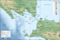
The Sunda Strait
-
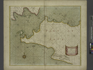
Map of the Sunda Strait in 1729 by Pierre van der Aa
-
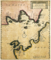
Map of the Sunda Strait circa 1702-1707
