
Maluku Islands facts for kids

The Maluku Islands (also called the Moluccas) are a group of islands in Indonesia. They are part of a larger group of islands known as the Malay Archipelago. These islands are located east of Sulawesi, west of New Guinea, and north of Timor. For a long time, people from China and Europe called them the "Spice Islands" because of the valuable spices found there.

Most of the Maluku Islands have many mountains. Some of these mountains are actually active volcanoes. The islands are small and often wet, which helps many plants grow. You can find thick rainforests, sago trees, and rice fields. The islands are most famous for their special spices, like nutmeg, cloves, and mace.
The first people to live on these islands were from Melanesia. Later, in the 1600s, many people, especially in the Banda Islands, died. Then, in the early 1900s, more people from the Malay group arrived. This happened when the Dutch ruled the islands, and it has continued even after Indonesia became independent.
How the Islands are Governed
From 1950 until 1999, the Maluku Islands were one single province of Indonesia. But in 1999, the northern part of the islands was separated. This new area became a different province called North Maluku. The islands are now divided into two provinces: Maluku and North Maluku. Between 1999 and 2002, there were some disagreements and unrest in the region. However, people from different groups, like Muslims and Christians, had lived peacefully together before this time.
Images for kids
-

Map by Willem Blaeu (1630)
-
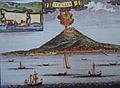
Drawing of Ternate by a presumably Dutch artist. Inset shows Saint John Baptist Portuguese-built fort on the island
-
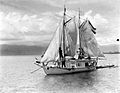
An orembai, a common traditional sailing vessel of the Maluku Islands
-
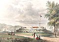
Fort Duurstede in Saparua, 1846
-
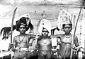
Tanimbar warriors
-
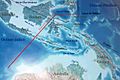
Map of Wallacea; upper right corner facing North. The red line denotes the western border of Wallacea. The eastern border corresponds to the light Australia–New Guinea shelf.
-

Ternate Island, as seen from Halmahera
-
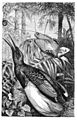
From The Malay Archipelago by Alfred Wallace (1869): illustration of king and twelve-wired birds-of-paradise by John Gerrard Keulemans.
-
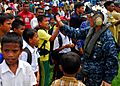
People of Tidore during visit by hospital ship USNS Mercy (T-AH-19)


.jpg)
See also
 In Spanish: Islas Molucas para niños
