Tidore facts for kids
Quick facts for kids
Tidore
|
||
|---|---|---|
|
City
|
||
| City of Tidore Islands Kota Tidore Kepulauan |
||
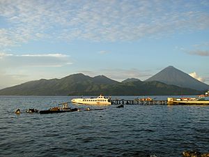
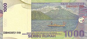
Tidore Island, as seen from Ternate Island.
|
||
|
||
| Motto(s):
Toma Loa Se Banari
(The Conscience of the People) |
||
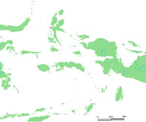
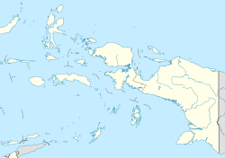
Location within Maluku Islands
|
||
|
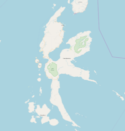
OpenStreetMap
|
||
| Country | ||
| Region | Maluku Islands | |
| Province | ||
| Area | ||
| • City | 1,703.32 km2 (657.66 sq mi) | |
| • Metro | 150.12 km2 (57.96 sq mi) | |
| Population
(mid 2023 estimate)
|
||
| • City | 118,613 | |
| • Density | 69.6364/km2 (180.3573/sq mi) | |
| • Metro | 65,459 | |
| • Metro density | 436.044/km2 (1,129.35/sq mi) | |
| Time zone | UTC+9 (Indonesia Eastern Time) | |
| Postcodes |
978xx
|
|
| Area code | (+62) 921 | |
| Vehicle registration | DG | |
| Website | tidorekota.go.id | |
Tidore is a city, an island, and a group of islands in eastern Indonesia. It is part of the North Maluku Province. The city of Tidore Islands includes the main island of Tidore and three smaller islands: Mare, Maitara, and Filonga. It also covers a large part of Halmahera Island to its east.
Long ago, the Sultanate of Tidore was a very powerful kingdom in the region. It was a strong competitor to nearby Ternate, another sultanate to the north.
Contents
Exploring Tidore's Geography
Tidore Island is home to a large stratovolcano. This volcano rises from the ocean floor to about 1,730 meters (5,676 feet) above sea level. Its highest point is the cone-shaped Mount Kie Matubu on the island's south side.
The northern part of Tidore Island has a large caldera called Sabale. Inside this caldera, there are two smaller volcanic cones.
Tidore's Capital City
Soasio is the capital city of Tidore. It has its own port called Goto and is located on the eastern side of the island. Soasio also has a mini-bus station and a market. The sultan's palace in Soasio was rebuilt and finished in 2010.
A Look at Tidore's History
Tidore became a powerful sultanate in the 1400s. Its wealth came from the spice trade. For much of its history, Tidore was closely linked to, and often competed with, the Sultanate of Ternate.
Islam began to spread in Tidore around the late 1400s. However, Islamic influences in the area can be traced back even further, to the late 1300s.
Tidore's Alliances and Power
The sultans of Tidore ruled over most of southern Halmahera. Sometimes, they also controlled islands like Buru, eastern Ceram, and many islands near New Guinea.
In the 1500s, Tidore formed an alliance with the Spanish. Spain even built several forts on the island. Both Tidore and Spain did not fully trust each other. But for Tidore, having the Spanish nearby helped them fight against attacks from Ternate and their allies, the Dutch. The Dutch had a fort on Ternate.
For Spain, supporting Tidore helped stop the Dutch from becoming too powerful. The Dutch expansion threatened Spain's interests in Asia and the Pacific. Tidore also provided a useful base close to the center of Dutch power and was a source of valuable spices.
Independence and Dutch Influence
Even though it was technically part of the Spanish East Indies in the late 1500s and 1600s, the Tidore sultanate was one of the strongest and most independent states in the region. After the Spanish left in 1663, Tidore continued to resist direct control by the Dutch East India Company (VOC).
Sultan Saifuddin (who ruled from 1657 to 1687) was especially good at using payments from the Dutch for spices. He used these payments as gifts to strengthen his ties with Tidore's smaller territories. Because of this, many local people respected him. Unlike Ternate, Tidore rarely needed Dutch military help to govern its kingdom.
Tidore remained an independent state for a long time, even with increasing Dutch involvement, until the late 1700s. Like Ternate, Tidore allowed the Dutch to carry out their "spice eradication program." This program aimed to strengthen the Dutch spice monopoly by limiting spice production to only a few places. This made Tidore poorer and weakened its control over its outer territories.
The Nuku Rebellion
In 1780, Tidore was forced to sign a treaty that made it a Dutch vassal state. A prince named Nuku was unhappy with this. He left Tidore and declared himself Sultan of the Papuan Islands. This started a long guerrilla war.
People from Papua, southeast Halmahera, and eastern Ceram supported Prince Nuku. The British also supported Nuku as part of their fight against the Dutch in the Moluccas. Captain Thomas Forrest was a British ambassador who worked closely with Nuku.
Nuku finally took control of Tidore in 1797. He also helped the British conquer Ternate in 1801. However, his successor, Zainal Abidin, was removed by Dutch forces in 1806. Tidore then came firmly under colonial rule.
The sultanate was officially ended during the Sukarno era in Indonesia. But it was brought back in 1999 with the 36th sultan. Tidore was mostly unaffected by the conflicts of 1999 that happened across the Maluku Islands.
How Tidore is Governed
The city of Tidore Islands is a municipality within the North Maluku province. It includes the main island of Tidore, three smaller islands (Mare, Maitara, and Filonga), and a large area on Halmahera Island called "Oba."
The entire municipality covers an area of about 1,703.32 square kilometers (657.66 square miles). In 2023, its population was estimated to be around 118,613 people.
Districts of Tidore City
The city is divided into eight districts (kecamatan). Four of these districts are on Tidore Island (including the three small islands). The other four districts are in the Oba area on the mainland of Halmahera.
The table below shows the districts, their areas, and populations from recent censuses and estimates. It also lists their administrative centers, the number of villages, and postcodes.
| Kode Wilayah |
Name of District (kecamatan) |
English name | Area in km2 |
Pop'n Census 2010 |
Pop'n Census 2020 |
Pop'n Estimate mid 2023 |
Admin centre |
No. of kelurahan |
No. of desa |
Post code |
|---|---|---|---|---|---|---|---|---|---|---|
| 82.72.01 | Tidore (a) | (Tidore town, or Soasio) |
36.08 | 18,477 | 22,975 | 22,602 | Tomagoba | 13 | - | 97811 -97813 |
| 82.72.04 | Tidore Selatan (b) | South Tidore | 42.40 | 13,129 | 14,671 | 15,190 | Gurabati | 6 | 2 | 97821 |
| 82.72.05 | Tidore Utara (c) | North Tidore | 37.64 | 14,573 | 17,294 | 17,895 | Rum | 10 | 4 | 97823 |
| 82.72.08 | Tidore Timur | East Tidore | 34.00 | 7,657 | 9,608 | 9,772 | Tosa | 7 | - | 97822 |
| (totals on Tidore Island) |
150.12 | 53,836 | 64,548 | 65,459 | 36 | 6 | ||||
| 82.72.02 | Oba Utara (d) | North Oba | 376.00 | 13,331 | 19,552 | 21,210 | Sofifi | 2 (e) | 11 | 97827 |
| 82.72.06 | Oba Tengah | Central Oba | 424.00 | 7,659 | 10,096 | 10,681 | Akelamo | 1 | 13 | 97826 |
| 82.72.03 | Oba | Oba | 403.67 | 10,337 | 13,628 | 14,349 | Payahe | 1 | 12 | 97824 |
| 82.72.07 | Oba Selatan | South Oba | 196.58 | 4,892 | 6,656 | 6,914 | Lifofa | - | 7 | 97825 |
| (totals on Halmahera Island) |
1,400.25 | 36,219 | 49,932 | 53,154 | 4 | 43 |
Notes: (a) This includes Filonga Island, which is northeast of Tidore Island. (b) This includes Mare Island, a volcanic island of 11 square kilometers (4.2 square miles) south of Tidore. (c) This includes Maitara Island, located northwest of Tidore (between Tidore and Ternate). It is 2 square kilometers (0.77 square miles) and has about 3,600 residents. (d) This includes the town of Sofifi, which has been the capital of North Maluku province since 2010. (e) Sofifi and Guraping are the two urban villages (kelurahan) in this district.
See also
 In Spanish: Tidore para niños
 | Frances Mary Albrier |
 | Whitney Young |
 | Muhammad Ali |


