
Timor facts for kids
|
Native name:
|
|
|---|---|

Timor as seen from space in 1989
|
|

Top: Political division of Timor between Indonesia and East Timor
Bottom: Location of Timor in Indonesia |
|

Timor
Location in Indonesia
Top: Political division of Timor between Indonesia and East Timor
Bottom: Location of Timor in Indonesia |
|
| Geography | |
| Location | Southeast Asia |
| Coordinates | 9°14′S 124°56′E / 9.233°S 124.933°E |
| Area | 30,777 km2 (11,883 sq mi) |
| Area rank | 44th |
| Highest elevation | 2,963 m (9,720 ft) |
| Highest point | Ramelau |
| Administration | |
| Largest settlement | Dili (pop. 277,488 as of 2023[update]) |
| Province | |
| Largest settlement | Kupang (West Timor) (pop. 455,850 as of 2021[update]) |
| Demographics | |
| Population | 3,311,735 (2020) |
| Pop. density | 107.6 /km2 (278.7 /sq mi) |
Timor is a large island located in Southeast Asia, north of Australia. Its name comes from the Malay word timur, meaning "east," because it is at the eastern end of the Lesser Sunda Islands. The island is divided into two countries: East Timor (also called Timor-Leste) in the east, and Indonesia in the west. The Indonesian part is known as West Timor. East Timor also has a small area called Oecusse District located inside West Timor. The island covers about 30,777 square kilometers. Mainland Australia is less than 500 kilometers away, across the Timor Sea.
Contents
People, Languages, and Beliefs

Scientists have found eleven different groups of people on Timor, each with its own language and culture. The biggest groups are the Atoni in West Timor and the Tetum in central and eastern Timor. Most native Timorese languages belong to the Austronesian languages family, which is spoken across many islands in Indonesia. Some languages on Timor are very unique and might be related to languages from New Guinea.
The official languages of East Timor are Tetum and Portuguese. In West Timor, the official language is Indonesian. However, many people in West Timor also speak Uab Meto, a local Atoni language. Indonesian is also widely understood in East Timor.
Most people on Timor are Christian, making up about 90% of the population. In West Timor, about 58% are Protestant and 37% are Catholic. In East Timor, almost everyone (98%) is Catholic, with 1% Protestant. Other religions, like Islam and traditional beliefs (animism), make up the rest of the population.
Island Geography
Timor is one of the easternmost Sunda Islands, located north of Australia. It is part of a chain of islands called the Lesser Sunda Islands. To its north are islands like Flores and Alor.
Timor was formed when the Indo-Australian Plate crashed into the Eurasian Plate. This powerful collision pushed up the land, creating the island's mountains. The island has a long dry season from April to November, with hot winds blowing from Australia. Rivers on the island include the North and South Laclo Rivers in East Timor. The mountains can reach almost 3,000 meters high. Mount Ramelau is the highest mountain in East Timor, and Mutis is the highest in West Timor.
The biggest towns on Timor are Kupang in West Timor (Indonesia) and Dili and Baucau in East Timor. Traveling to inland areas can be hard because the roads are often poor. The island earns money from things like gas and oil found in the Timor Sea, growing coffee, and tourism.
How Timor Was Formed
Timor is a special place where two huge land plates, the Eurasian Plate and the Australian Plate, have collided. This crash has pushed up layers of rock, creating the island we see today. Scientists are still studying exactly how these rocks were pushed and folded.
Timor also has a lot of oil and gas underground and offshore. Many natural oil and gas seeps (places where oil or gas naturally leaks out of the ground) are found on the island, especially in the north. Scientists look for these signs to find places where oil and gas might be trapped deep below the surface. Some rocks on the island are very rich in carbon, which means they could be good "source rocks" for oil and gas.
How the Island is Governed
Timor is divided into two main parts, each governed by a different country.
West Timor
West Timor is part of the East Nusa Tenggara province of Indonesia. It is divided into several areas called regencies. These include Kupang Regency, South Central Timor Regency, North Central Timor Regency, Belu Regency, and Malaka Regency. The city of Kupang is also a separate administrative area. Some islands nearby, like Rote and Savu, used to be part of Kupang Regency but are now separate. West Timor is home to about 35.5% of the province's total population.
East Timor
East Timor is divided into thirteen main areas called municipalities. These municipalities are then split into smaller parts: 65 administrative posts, 442 villages (called sucos), and 2,225 hamlets (called aldeias).
Plants and Animals
Timor and its nearby islands, like Atauro and Jaco, are part of a special natural area called the Timor and Wetar deciduous forests ecoregion. This area has a mix of plants and animals from both Asia and Australia. The natural forests here are mostly "tropical dry broadleaf forests," meaning many trees lose their leaves during the dry season.
Sadly, much of the original forest has been cut down for farming, especially along the coasts. Only small patches remain, except for one larger forest in the center of Timor. Common trees in the lowlands include Sterculia foetida and Aleurites moluccanus.
Long ago, during the Pleistocene Ice Age, Timor was home to giant monitor lizards, similar to the Komodo dragon. It also had dwarf elephant relatives called stegodonts.
Today, Timor has many unique animals. These include the Timor shrew and the Timor rat, which are found nowhere else. The northern common cuscus, a marsupial from Australia, also lives here, but it might have been brought to the island by people. Timor is a great place for birds, with 250 different species. Twenty-four of these are found only on Timor, including five species that are endangered, like the iris lorikeet.
Saltwater crocodiles live in the wetlands, and reticulated pythons can be found in the forests and grasslands. Scientists are still learning about how many of these animals live on the island.
Several types of frogs live on Timor, including Duttaphrynus melanostictus and Litoria everetti. A new type of tiny frog from the genus Kaloula was also recently found here.
Fossils of ancient sea animals have been found in East Timor. These include large marine reptiles called mosasaurs and ancient sharks.
Island History


The earliest records of Timor come from Chinese writings in the 1200s, which mentioned the island for its valuable sandalwood. In the 1300s, a Javanese poem also named Timor as part of the Majapahit kingdom. Timor became an important trading center for sandalwood, honey, and wax.
In the late 1500s, the Portuguese arrived and settled on the island. Later, in the mid-1600s, the Dutch also came and set up a base in Kupang.
Timor became famous in 1789 when William Bligh and his loyal sailors landed there after the famous Mutiny on the Bounty. It was also a landing spot for survivors of the ship HMS Pandora in 1791.
For centuries, the island was politically divided. The Dutch and Portuguese often fought for control until they officially divided the island with a treaty in 1859. However, they didn't fully agree on the border until 1912. West Timor became Indonesian Timor in 1949, as part of the new nation of Indonesia. East Timor remained a Portuguese colony until 1975.
During World War II, even though Portugal was neutral, Australian and Dutch forces occupied Portuguese Timor in 1941, expecting a Japanese invasion. When the Japanese did invade in February 1942, a small Dutch-Australian force and many Timorese volunteers fought them in a guerrilla war for a year. The Timorese people helped the Allies, which led to many villages being burned and food supplies taken by the Japanese. Between 40,000 and 70,000 Timorese people died during the Japanese occupation.
After a military coup in Portugal in 1974, the Portuguese began to leave Timor. This led to fighting within East Timor. Fearing a communist government, Indonesia invaded East Timor in 1975. Indonesia then claimed East Timor as its 27th province, calling it Timor Timur. However, the United Nations and Portugal never recognized this.
The people of East Timor, led by the Falintil military group, fought against 35,000 Indonesian troops in a long guerrilla campaign. The island remained under Indonesian control until 1999. In that year, a vote was held under a UN-sponsored agreement. The people of East Timor voted against being part of Indonesia. The UN then temporarily governed East Timor until it became an independent country called Timor-Leste in 2002. Xanana Gusmão, a Falintil leader, became its first president.
Since 2001, some people on the Indonesian side of Timor have talked about creating a "Great Timor" state. However, most people in West Timor are not interested in joining East Timor. The current government of East Timor also respects the existing border.
Time Zones
The island of Timor uses two different time zones:
- UTC+8: This time zone is used in East Nusa Tenggara (West Timor), Indonesia.
- UTC+9: This time zone is used in most of East Timor.
Images for kids
-
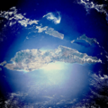
Timor as seen from space in 1989
-
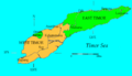
Top: Political division of Timor between Indonesia and East Timor
Bottom: Location of Timor in Indonesia -
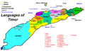
Language map of Timor
-
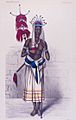
Portrait of a Timorese warrior in the area of Kupang in 1875.
-
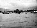
Boats along the Timor coast
See also
 In Spanish: Timor para niños
