West Timor facts for kids
Quick facts for kids
West Timor
Timor Barat
Dutch Timor Indonesian Timor |
|
|---|---|
|
Region
|
|

Location of West Timor in Timor Island
|
|
| Country | |
| Province | |
| City | Kupang |
| Regencies | Belu Regency, Kupang Regency, Malaka Regency, Rote Ndao Regency, Sabu Raijua Regency, North Central Timor, South Central Timor |
| Area | |
| • Total | 16,264.78 km2 (6,279.87 sq mi) |
| Elevation
(
Mount Mutis) |
2,427 m (7,963 ft) |
| Population
(2019)
|
|
| • Total | 1,978,000 |
| • Density | 121.612/km2 (314.97/sq mi) |
| Time zone | UTC+8 (Indonesia Central Time) |
| Area code(s) | (62)3xx |
| Vehicle sign | DH |
| HDI | |
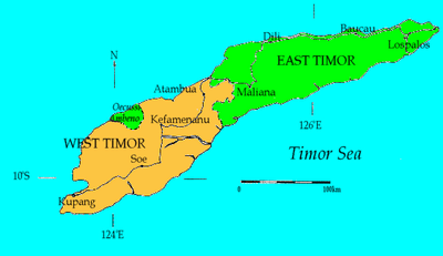
West Timor is the western part of Timor island. It is part of Indonesia and belongs to the East Nusa Tenggara Province. The only part of western Timor that is not West Timor is a small area called Oecussi-Ambeno, which belongs to East Timor.
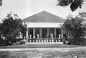
The main city and port in West Timor is Kupang. In the past, during the time of colonies, this area was known as Dutch Timor. It was a place where people supported the Dutch during the Indonesian National Revolution (1945–1949). From 1949 to 1975, it was called Indonesian Timor.
West Timor covers about 16,265 square kilometers (6,280 square miles). The highest mountains are Mount Mutis, which is 2,427 meters (7,963 feet) high, and Mount Lakaan, which is 1,600 meters (5,249 feet) high.
Many languages are spoken here, including Dawan, Marae, and Tetun. Some of these languages, like Kemak, Bunak, and Helong, are also used in East Timor. Other languages, like Ndao, Rote, and Sabu, are only spoken in West Timor.
From 1998 to 2002, West Timor became a safe place for people seeking shelter. This was because of the conflict in East Timor in 1999. Some of the biggest towns are Kupang City with over 400,000 people, Atambua with over 86,000, Kefamenanu with over 40,000, and Soe City with over 40,000 people.
Contents
A Look at West Timor's Past
Europeans started to explore and claim Timor in the 1500s. The Portuguese said they owned Timor in 1520. However, the Dutch, through their company called the Dutch East India Company, settled in West Timor in 1640. This made the Portuguese move to what is now East Timor.
Later, the Dutch company stopped existing in 1799, and West Timor officially became part of Dutch rule. In 1914, the border between East and West Timor was finally set. This happened because of a treaty between Portugal and the Netherlands that was first signed in 1859 and changed in 1893.
West Timor was a special area called a residency under Dutch rule. During World War II, Japan took over the island in early 1942. After Indonesia became independent, West Timor joined the new Republic of Indonesia.
Exploring West Timor's Geography
West Timor is the western part of Timor island. It is not a separate country but is part of the Indonesian province of East Nusa Tenggara. The only part of western Timor that is not included is the Oecusse district, which belongs to East Timor.
The total land area of West Timor is about 16,265 square kilometers. The highest point is Mount Mutis, which stands at 2,427 meters (7,963 feet) tall.
West Timor has many large, open grasslands called savannas. The air is often dry, and there is not much rain.
Rote Island, which is the southernmost island of Indonesia, is located southwest of West Timor.
The biggest town and main port in West Timor is Kupang. Kupang is also the capital city of the Nusa Tenggara Timur province.
West Timor is located between Australia and East Timor. This makes it an important place for trade in Indonesia.
How West Timor is Governed
West Timor is part of the East Nusa Tenggara province in Indonesia. It is divided into several areas called regencies (kabupaten). The main city, Kupang, is also a regency-level area.
Here are the regencies in West Timor:
- Kupang Regency
- South Central Timor
- North Central Timor
- Belu Regency
- Malaka Regency (formed in 2012 from part of Belu Regency)
Some islands that were once part of Kupang Regency, like Rote Ndao Regency (Rote and Ndoa islands) and Sabu Raijua Regency (Savu Islands), became separate regencies in 2002 and 2009. West Timor is home to about 35.5% of the people in the province.
| Name | Capital City | Area (km2) | Population (2019) |
|---|---|---|---|
| Kupang Regency | Kupang | 5898.18 | 402000 |
| South Central Timor Regency | Soe | 3947.00 | 466000 |
| North Central Timor Regency | Kefamenanu | 2669.66 | 256000 |
| Belu Regency | Atambua | 1284.94 | 226000 |
| Malaka Regency | Betun | 1160.63 | 190000 |
| Kupang City |
|
160.34 | 438000 |
| West Timor | Kupang | 15120.83 | 1978000 |
People and Languages of West Timor
In 2019, about 1.98 million people lived in West Timor. Some of these people were refugees who came after the violence in East Timor in 1999.
Languages Spoken
Besides the national language, Indonesian, people in West Timor speak many local languages. These languages belong to the Austronesian language family. Some of them are also spoken in East Timor. These include Uab Meto, Tetum, Ndaonese, Rotinese, and Helong.
Older people might still know some Dutch, which was the language of the colonial rulers.
Religions in West Timor
Most people in West Timor are Christian, making up over 97% of the population. About 2.9% of the people follow Islam. A very small number of people, about 0.088%, are Hindus or Buddhists. The main Catholic areas are the Archdiocese of Kupang and the Diocese of Atambua.
West Timor's Economy
West Timor has an average unemployment rate of 2.39%. In 1998, 30% of the people lived below the poverty line, and this number was still the same in 2012.
The economy mainly relies on farming. Farmers often use a method called slash-and-burn to grow crops like corn, rice, coffee, copra (dried coconut meat), and various fruits.
Some timber is also harvested from trees like eucalyptus, sandalwood, teak, bamboo, and rosewood.
See also

- In Spanish: Timor Occidental para niños
 | Jessica Watkins |
 | Robert Henry Lawrence Jr. |
 | Mae Jemison |
 | Sian Proctor |
 | Guion Bluford |


