Atauro facts for kids
Quick facts for kids
Atauro
|
|
|---|---|
|
Island and Municipality of East Timor
|
|
|
|
![Atauro's coastline at Beloi [de]](/images/thumb/9/9d/Atauro_coast_2.jpg/300px-Atauro_coast_2.jpg)
Atauro's coastline at Beloi
|
|

|
|
|
OpenStreetMap
|
|
| Country | |
| Capital | Vila Maumeta |
| Area | |
| • Total | 140.1 km2 (54.1 sq mi) |
| Area rank | 14th |
| Population
(2015 census)
|
|
| • Total | 9,274 |
| • Rank | 14th |
| • Density | 66.196/km2 (171.45/sq mi) |
| • Density rank | |
| Households (2015 census) | |
| • Total | 1,748 |
| • Rank | 14th |
| Time zone | UTC+09:00 (TLT) |
| HDI (2017) | 0.733 (as part of Dili Municipality) high · 1st |
| Website | https://atauro.gov.tl/ |
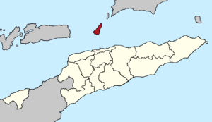
Atauro is a beautiful island and a special area (called a municipality) in East Timor. It's also known as Kambing Island. This small island is located north of Dili, the capital city of East Timor. It sits between the Indonesian islands of Alor and Wetar.
In 2015, about 9,274 people lived on Atauro. The island used to be part of the Dili area. But on January 1, 2022, Atauro became its own separate municipality.
Contents
What's in a Name?
The name Atauro means 'goat' in the local language. That's why Indonesians also call it Kambing Island, because Kambing means 'goat' in Indonesian. The island got this name because many goats live there.
Exploring Atauro's Geography

Atauro is about 23.5 kilometers (14.6 miles) north of Dili on mainland Timor. It is 22 kilometers (14 miles) long and 5 to 10 kilometers (3 to 6 miles) wide. The island covers an area of about 150 square kilometers (58 square miles).
The island is divided into five main areas called sucos. Each suco has a village. These are Biqueli and Beloi in the north, Macadade in the southwest, and Maquili and Vila Maumeta in the southeast. Vila Maumeta is the biggest village on the island.
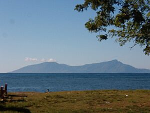
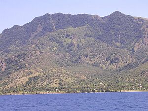
The highest point on Atauro is Mount Manucoco, which is 999 meters (3,278 feet) above sea level. The ocean between Atauro and Timor is very deep, dropping 3,500 meters (11,500 feet) below sea level.
A ferry called the Berlin Nakroma, which was a gift from Germany, connects Atauro to Dili. The trip takes about two hours. You can also get to Dili by local fishing boats. Atauro is becoming a popular spot for eco-tourism and scuba diving because of its amazing coral reefs.
Atauro is a rugged island with many hills. It sometimes has landslides. Finding enough fresh water can be a challenge, especially during the dry season. There are some natural springs and wells along the coast. In 2004, Portugal helped with a project to improve water supply, but water shortages can still happen.
Atauro's Divisions
Atauro Municipality is split into these five areas called Sucos:
- Suco Beloi
- Suco Biqueli
- Suco Macadade
- Suco Maquili
- Suco Vila
Nature and Environment
Atauro's landscape was formed by ancient underwater volcanoes. This created narrow ridges and steep slopes. The island has a wet and dry season each year.
The higher parts of Mount Manucoco (above 700 meters or 2,300 feet) still have patches of tropical mountain forest. Lower down, you can find drier forests and savanna woodlands. Farmers also use land near the villages for crops.
The island has a fringing reef around its coast, which is 30 to 150 meters (98 to 492 feet) wide. In 2016, a team from Conservation International discovered that the waters around Atauro have more types of reef fish than almost anywhere else in the world! They found up to 315 different species in one spot. However, the waters around Atauro do get some marine plastic pollution from Dili and nearby Indonesia.
Birds of Atauro
The entire island, especially the area around Mount Manucoco, is an important place for birds. It's known as an Important Bird Area (IBA). Many special birds live here, including:
- bar-necked cuckoo-doves
- black cuckoo-doves
- Timor green pigeons
- pink-headed imperial pigeons
- olive-headed lorikeets
- plain gerygones
- fawn-breasted whistlers
- olive-brown orioles
- Timor stubtails
- Timor leaf warblers
- orange-sided thrushes
- blue-cheeked flowerpeckers
- flame-breasted sunbirds
- tricolored parrotfinches
Atauro's Culture
Atauro is unique in East Timor because many people in the northern part of the island are Protestants, not Catholics. They were taught about Protestantism by a Dutch mission from Alor in the early 1900s. Some people in the south are also Protestant.
The people of Atauro speak four different dialects of Wetarese. This language originally came from the island of Wetar in Indonesia.
A Glimpse into History
Historically, Atauro was divided into three main areas, each with several family groups or clans. These groups sometimes formed alliances to protect themselves from pirates and raiders who came from nearby islands. They also sometimes fought among themselves over resources.
In 1859, the Netherlands and Portugal agreed that Atauro belonged to Portugal. The Portuguese flag was officially raised in 1884. Atauro was used as a prison island by the Portuguese.
During Portuguese rule, Atauro was part of the Dili area. When East Timor became independent, there was a plan to make Atauro its own special area. This finally happened on January 1, 2022, when it became a separate municipality.
On August 26, 1975, the Portuguese Governor left Dili and went to Atauro. He tried to help solve problems between different groups in East Timor. On December 10, 1975, Indonesia invaded East Timor. In the 1980s, the Indonesians also used Atauro as a prison for East Timorese fighters.
Atauro became part of independent East Timor on May 20, 2002.
Images for kids
See also
 In Spanish: Atauro para niños
 | Victor J. Glover |
 | Yvonne Cagle |
 | Jeanette Epps |
 | Bernard A. Harris Jr. |


