
Altiplano Cundiboyacense facts for kids
Quick facts for kids Altiplano Cundiboyacense |
|
|---|---|

|
|
| Location | Bogotá, Cundinamarca & Boyacá |
| Coordinates | 5°25′08″N 73°25′17″W / 5.41889°N 73.42139°W |
| Range | Andes |
| Part of | Eastern Ranges |
| Offshore water bodies | Water bodies |
| Elevation | 2,600 metres (8,530 ft) |
| Area | 25,000 km2 (9,700 sq mi) |
| Geology | Geology |
| Age | Miocene-recent |
| Orogeny | Andean |
| Volcanic field | Paipa-Iza volcanic complex |
| Last eruption | Late Pliocene |
The Altiplano Cundiboyacense is a large, high flat area (a plateau) found in the Andes mountains of Colombia. It covers parts of the Cundinamarca and Boyacá regions. This area was once the home of the ancient Muisca civilization.
The Altiplano Cundiboyacense has three main flat parts. These are the Bogotá savanna, the valleys of Ubaté and Chiquinquirá, and the valleys of Duitama and Sogamoso. The plateau is about 2,600 metres (8,500 ft) above sea level on average. However, some parts can be as low as 2,500 metres (8,200 ft) or as high as 4,000 metres (13,000 ft).
Contents
What's in a Name?
The name Altiplano comes from Spanish. It means "high plain" or "high plateau". The second part, "Cundiboyacense", combines the names of the two departments it covers: Cundinamarca and Boyacá.
Exploring the Geography
The Altiplano is surrounded by taller mountains of the Eastern Ranges. To the south are the Sumapaz mountains, and to the east is Chingaza. Other nearby areas include the Tenza Valley and the Ocetá Páramo.
Main Sections
The Altiplano is split into three main valleys:
- The Iraca Valley (in the northeast)
- The Ubaté & Chiquinquirá Valley
- The Bogotá savanna (in the southwest)
Weather and Climate
The average temperature on the Altiplano Cundiboyacense is about 14 °C (57 °F). Temperatures can range from 0 °C (32 °F) to 24 °C (75 °F). The driest months are from December to March. More rain falls in April, May, September, October, and November. Strong winds blow from June to August. Sometimes, hail (ice pellets) falls on the Altiplano.

Unique Mountain Ecosystems
The Altiplano Cundiboyacense is surrounded by special mountain ecosystems called páramos. These are unique grasslands found only in high-altitude tropical regions. Colombia has 60% of all the world's páramos! The Boyacá department, where much of the Altiplano is located, has a large share of these important areas.
The Sumapaz Páramo, the largest in the world, forms a natural border to the south. Chingaza also has páramo plants. The beautiful Ocetá Páramo is in the northeast. Even around Lake Iguaque on the Altiplano, there's a small páramo area.

A Look Back in Time
Ancient History

The Altiplano Cundiboyacense was formed as the Andes mountains slowly rose over millions of years. Long ago, from the Early Cretaceous period until the Eocene epoch, this region was covered by a warm, shallow sea. This sea was part of a larger inland sea in northern South America.
Amazing sea creatures lived here, like ichthyosaurs and pliosaurs. Important fossils have been found in places like Villa de Leyva. One famous fossil is Kronosaurus boyacensis, nicknamed El Fósil. Another is Muiscasaurus, a reptile with four nostrils!
Around 35-30 million years ago, South America separated from Antarctica. This made South America an isolated continent, leading to many unique animal species. For millions of years, giant "terror birds" were the top predators. Fossils of these birds have been found across South America.
Later, around 3 million years ago, the Panama Block (the land bridge connecting North and South America) rose from the sea. This allowed animals to move between the two continents in what is called the Great American Biotic Interchange. Many new species arrived in South America, changing its animal life.
Ice Age and Early Humans
During the last Ice Age (Pleistocene epoch), giant animals called Pleistocene megafauna lived in the highlands of the Andes. The cold climate created many prehistoric lakes in the Altiplano's valleys. The Ubaté-Chiquinquirá Valley was covered by a large lake. Today, Lake Fúquene is a small part of it. The largest ancient lake was Lake Humboldt, which covered the Bogotá savanna. This lake was huge, much larger than Colombia's biggest lake today, Lake Tota.
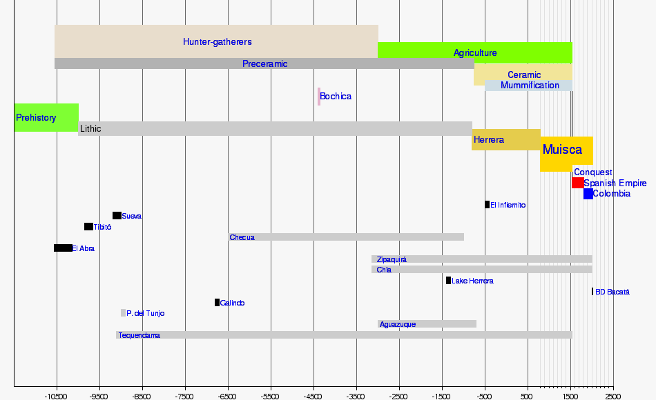
The Altiplano Cundiboyacense is an important archaeological area. The earliest signs of humans here date back about 12,400 years ago in a place called El Abra. Other ancient sites like Tibitó and Tequendama show that hunter-gatherers lived here. These early humans shared the land with giant animals like Cuvieronius and Haplomastodon.
Life Before the Spanish

Over time, people moved from living in rock shelters to open settlements. They hunted animals like white-tailed deer and guinea pigs. They also gathered plants for food. Many ancient burial sites have been found, showing how people lived and died.
Ancient Art
Many sites with petroglyphs (carvings on rocks) and pictographs (paintings on rocks) have been found on the Altiplano. These include places like Bojacá, Bogotá, Chía, and Facatativá. They tell us stories about the ancient people.
The Muisca Civilization
The Muisca were the main inhabitants of the central Andean highlands before the Spanish arrived. They lived in a loose group of communities called the Muisca Confederation. Each community had its own leader, like the zipa of Bacatá and the zaque of Hunza. The iraca lived in the sacred City of the Sun, Sugamuxi.
The Muisca were known as "Salt People" because they mined salt from places like Zipaquirá and Nemocón. They had a well-organized economy and traded valuable items like gold, tumbaga (a metal alloy), and emeralds with other groups. They also mined emeralds in the Tenza Valley.
Their economy was based on farming. They grew maize (corn), yuca, and potatoes. Farming started around 3000 BCE on the Altiplano. The Muisca used terraces and irrigation systems to grow their crops, especially in the often-flooded highlands. They planted their crops in rows of mounds.
The Spanish Arrival
In 1536, a Spanish expedition led by Gonzalo Jiménez de Quesada traveled through Colombia. They were searching for a legendary land of gold called El Dorado. In March 1537, De Quesada's troops reached Muisca lands. They founded their first settlement, Chipatá.
The Spanish continued into the Altiplano, founding towns like Guachetá and Lenguazaque. They eventually reached the Bogotá savanna and defeated the Muisca leader, zipa Tisquesusa, in Funza. This led to more expeditions. The Spanish also conquered the zaque Quemuenchatocha in Hunza and the iraca Sugamuxi in the Iraca Valley. Sadly, the important Sun Temple was accidentally burned by Spanish soldiers.
On August 6, 1538, Gonzalo Jiménez de Quesada founded Bogotá. It became the capital of the new Spanish territory, the New Kingdom of Granada. Other Spanish leaders arrived, and eventually, the Muisca Confederation came under Spanish rule.
Today
Today, the Altiplano has a large population and a lot of farming. Because of this, some of the original plants and natural areas are at risk.
Timeline of Human Life
| Timeline of inhabitation of the Altiplano Cundiboyacense, Colombia | |
 |
  .png) |
Important Cities

The biggest city on the Altiplano Cundiboyacense is Bogotá, the capital of Colombia. Other important cities include:
- Sogamoso
- Duitama
- Chiquinquirá
- Villa de Leyva
- Tunja
- Ubaté
- Suesca
- Tocancipá
- Zipaquirá
- Cajicá
- Chía
- Facatativá
- Soacha

Waterways and Lakes


The Altiplano Cundiboyacense has many rivers and lakes.
Rivers
- The Bogotá River is a major river in the region.
- Other rivers include the Sogamoso River, Chicamocha River, and Suárez River.
Lakes
Natural Lakes
- Lake Tota, the largest lake in Colombia.
- Lake Fúquene
- Lake Guatavita
- Lake Herrera
- Lake Iguaque
- Siecha Lakes
- Lake Suesca
Man-made Lakes
- La Copa Reservoir
- El Muña Reservoir
- Neusa Reservoir
- San Rafael Reservoir
- Sisga Reservoir
- Lake Sochagota
- Tominé Reservoir
Waterfalls
- Tequendama Falls are impressive waterfalls in the area.
Wetlands
The Altiplano also has many important wetlands, which are areas where water covers the soil. These include:
- El Burro
- La Conejera
- Santa María del Lago

Altiplanos Around Latin America
| Latin America | Valley of Mexico | Altiplano Cundiboyacense | Altiplano Boliviano |
|---|---|---|---|
.svg)
M
C
B
|
 |
|
 |
| Ancient Lake | Lake Texcoco | Lake Humboldt | Lake Tauca |
| First Humans (years ago) | 11,100 – Tocuila | 12,560 – El Abra | 3530 – Tiwanaku |
| Ancient Civilization | Aztec | Muisca | Inca |
| Today | |||
| Height (above sea level) | 2,236 m (7,336 ft) | 2,780 m (9,120 ft) | 3,800 m (12,500 ft) |
| Size (area) | 9,738 km2 (3,760 sq mi) | 25,000 km2 (9,700 sq mi) | 175,773 km2 (67,866 sq mi) |
| References |
See Also
 In Spanish: Altiplano cundiboyacense para niños
- Altiplano Nariñense
- Andes, Bogotá savanna
- Eastern Hills, Bogotá
- Muisca, Muisca Confederation, Ocetá Páramo
- Tenza Valley, Chicamocha Canyon
