
El Abra facts for kids

Petroglyph of El Abra
|
|

Location in Colombia
|
|
| Location | Zipaquirá, Tocancipá, Cundinamarca |
|---|---|
| Region | Bogotá savanna Altiplano Cundiboyacense |
| Coordinates | 5°01′02.49″N 73°57′04.33″W / 5.0173583°N 73.9512028°W |
| Altitude | 2,570 m (8,432 ft) |
| Type | Rock shelter, petroglyphs |
| Part of | Pre-Muisca sites |
| History | |
| Material | Sandstone |
| Abandoned | Herrera Period |
| Periods | Prehistory-Herrera |
| Cultures | Preceramic hunter-gatherers |
| Site notes | |
| Excavation dates | 1967 |
| Archaeologists | Correal, Hammen |
| Ownership | Hacienda El Abra, Cesar Orjuela |
| Public access | Partly |
| Designation | Climbing area |
El Abra is a very old archaeological site in Colombia. It is located in the El Abra valley, between the towns of Zipaquirá and Tocancipá in the Cundinamarca region. This area is part of the Bogotá savanna, high up in the Andes mountains.
El Abra is a series of rock shelters and caves. It is important because it shows some of the earliest signs of humans living in the Americas. Scientists have found evidence that people lived here about 12,400 years ago. These early people were hunter-gatherers. They hunted animals and gathered plants for food.
Contents
What's in a Name?
The name "El Abra" comes from a large farm, or hacienda, nearby. This farm is at the base of the rock formations. The eastern part of these sandstone rocks is open for visitors. You can even go rock climbing there!
Finding Out How Old It Is
Scientists first started studying El Abra in 1967. They looked at different layers of soil and rock. In these layers, they found old stone tools, animal bones, and pieces of burnt wood. By using a method called radiocarbon dating, they could figure out how old these things were. This is how they learned that people lived here around 12,400 years ago.
Exploring Ancient Life
In the late 1960s, more research was done at El Abra. A Dutch foundation also helped find four new ancient sites. By studying the soil from old lakes, scientists learned more about the climate and plants from long ago.
Cold Times (Fúquene Stadial)
From about 15,000 to 12,500 years ago, the climate was very cold. This period is called the Fúquene stadial, named after Lake Fúquene. The plants were like those found in very cold, high-altitude areas. People living then used simple stone tools.
Warmer Times (Guantivá Interstadial)
Around 12,500 years ago, the weather slowly got warmer. This allowed cloud forests to grow again. More animals moved into the area, which made hunting easier for people. The tools from this time are called abriense tools. They include flint tools and chopper cores. As the climate improved, people started to leave the caves and live in more open areas.
The Tibitó Period
About 11,400 years ago, another important site near El Abra was used. This site is called Tibitó. At Tibitó, scientists found stone tools and bone tools. They also found bones from huge animals that lived during the Pleistocene Ice Age. These animals included mastodons, ancient horses, and deer. There are even signs that people held special ceremonies with these animals.
Another Cold Spell (El Abra Stadial)
Around 11,000 years ago, the climate got cold again. Forests shrank, and glaciers grew. During this time, the Tequendama site became important. Tools found there were smoother and made from different materials. Some materials were brought from far away, like the Magdalena River valley. At Tequendama, there is also evidence that people started to tame guinea pigs.
Modern Times (Holocene)
About 10,000 years ago, the last Ice Age ended. The climate became warmer, and the Andean forests returned. The tools from this period show that people started to gather more plants and hunt smaller animals like rodents. The El Abra caves were slowly left behind. People moved to other nearby rock shelters, like Nemocón, or settled in open areas like Checua.
Early Farming (Aguazuque)
Around 5,000 years ago, at a place called Aguazuque, people began to farm. They built terraces to grow crops. Grinding stones, used for processing food, have been found there. The old abriense type tools were no longer used.
Visiting El Abra
Part of the El Abra rock formation is on private land in Zipaquirá, so access is limited. However, the eastern side in Tocancipá is open to the public. There are about 20 different routes for rock climbing there. The climbing at El Abra is known to be more challenging than at the famous Suesca climbing area. This is because the rock formations at El Abra often hang over.
Gallery
-
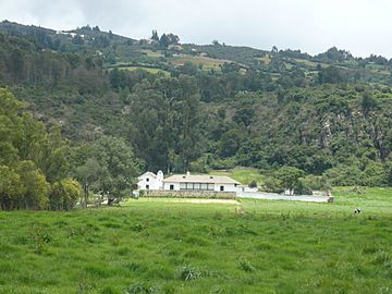
Hacienda El Abra, a farm near the rocks
-
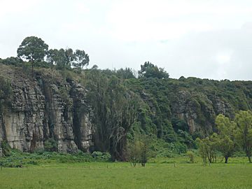
The impressive rock formation of El Abra
-
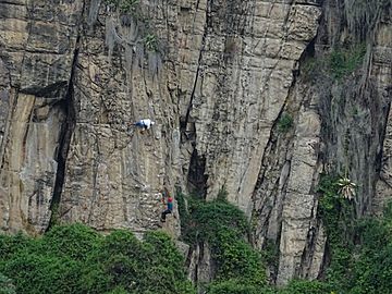
People enjoying climbing at El Abra


See also
 In Spanish: El Abra para niños
