
Zipaquirá facts for kids
Quick facts for kids
Zipaquirá
|
||
|---|---|---|
|
Municipality and city
|
||

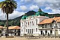
Central square of Zipaquirá
|
||
|
||

Location of the town and municipality of Zipaquirá in Cundinamarca
|
||

Zipaquirá
Location in Colombia
|
||
| Country | ||
| Departamento | Cundinamarca | |
| Province | Central Savanna Province | |
| Founded | 18 July 1600 | |
| Founded by | Luis Henríquez | |
| Area | ||
| • Municipality and city | 194.8 km2 (75.2 sq mi) | |
| • Urban | 10.25 km2 (3.96 sq mi) | |
| Elevation | 2,650 m (8,690 ft) | |
| Population
(2018 census)
|
||
| • Municipality and city | 130,537 | |
| • Density | 670.11/km2 (1,735.6/sq mi) | |
| • Urban | 106,461 | |
| • Urban density | 10,386/km2 (26,901/sq mi) | |
| Demonym(s) | Zipaquireño/a | |
| Time zone | UTC-5 | |
| Area code(s) | +1 | |
| Website | Official website: http://www.zipaquira-cundinamarca.gov.co/ | |
| Censo DANE 2005 | ||


Zipaquirá is a city and municipality in Colombia. It is located in the Cundinamarca Department. The city is about 49 kilometers (30 miles) from Bogotá, the capital of Colombia. Zipaquirá is part of the larger Bogotá area. It is also the main city of the Sabana Centro province.
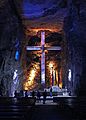
Zipaquirá is famous for its Salt Cathedral. This is an amazing underground church. It was built inside a salt mine. The city also has beautiful old buildings. Its main square looks like it did in Spanish colonial times. You can even reach this cool city by train from Bogotá!
Contents
What Does the Name Zipaquirá Mean?
The name Zipaquirá comes from the Chibcha language. This was the language of the Muisca. They lived in this area before the Spanish arrived. In Chibcha, the name means "The Land of the zipa". A Zipa was the ruler of this land. Another idea is that the name means "City of our father".
A Look at Zipaquirá's Past
Early History of Zipaquirá
Some of the oldest human remains in South America were found near Zipaquirá. These remains are about 12,500 years old. This shows that people lived here a very long time ago.
The Muisca people lived here before the Spanish. They settled on a mountain near a salt mine. Early Spanish visitors in 1537 saw many homes there. They estimated about 12,000 people lived in the area.
This land was ruled by the zipa of Bacatá. The Muisca people used canoes to travel on lakes and rivers. They came to Zipaquirá to get salt. Salt was very important. They traded it with other groups for things like pottery.
Zipaquirá in Spanish Colonial Times
On July 18, 1600, a Spanish official named Luis Henríquez started a new settlement. He called it the "Village of Zipaquirá". A church was built soon after.
In 1605, the area became known as the Corregimiento de Zipaquirá. The Spanish moved the town to its current location. This was because the original spot was too small. Also, Spanish rules said that Spanish people, Black people, and mixed-race people could not live in native villages.
In 1778, the Spanish moved the native people from Zipaquirá. They went to Nemocón. This was to stop them from rebelling over the salt mines. On August 3, 1816, some people were executed in the city square. They are known as the Zipaquirá Martyrs.
Zipaquirá in Modern Times
After Colombia became independent, Zipaquirá became important. In 1815, it was made the capital of its province. Later, in 1863, it was the capital of the Sovereign State of Cundinamarca for a short time. In 1905, it became the capital of the Department of Quesada until 1910.
About Zipaquirá Today
Zipaquirá is about 48 kilometers (30 miles) north of Bogotá. You can get there by road or by train. The city is famous for its salt mines. The amazing Salt Cathedral is built inside one of these mines.
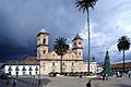
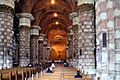
González Forero Square is the heart of the city. It has many old buildings that look like they did in colonial times. These buildings are now national monuments. The square has a beautiful stone cathedral. It was built between 1760 and 1870. The city hall and the salt administration building are also there. They have cool green roofs.
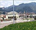
The city has made some changes recently. Streets in the center are now for walking only. This helps keep the old buildings safe. It also makes the city nicer for visitors. They also improved the train station. A new park called Parque La Esperanza was built next to it.
A new highway connects Bogotá, Chía, Cajicá, and Zipaquirá. This makes it faster and safer to travel to the city.
Zipaquirá has many things for visitors. You can find local restaurants and old colonial houses. Some houses are almost 300 years old! There are also museums and craft shops.
Farming is important here. People raise dairy cows and grow potatoes. The city's industry is mostly about salt. This includes making and processing salt. About 130,000 people live in Zipaquirá. They are called "Zipaquireños".
The city's streets, park, and houses remind people of the colonial era. They also remember the struggles of the native people. Many tourists visit to learn about the city's history.
One of the most famous events is the Holy Week processions. These are organized by the Nazarene of Zipaquirá Congregation. They have been happening for over 50 years. People carry beautiful religious statues through the streets. Many locals and visitors come to see them. On Good Friday, there is a procession called the Path of the Cross. It goes up to the entrance of the Salt Cathedral.
Zipaquirá's Climate
| Climate data for Zipaquirá/Nemocón (Checua-Nemocon), elevation 2,580 m (8,460 ft), (1981–2010) | |||||||||||||
|---|---|---|---|---|---|---|---|---|---|---|---|---|---|
| Month | Jan | Feb | Mar | Apr | May | Jun | Jul | Aug | Sep | Oct | Nov | Dec | Year |
| Mean daily maximum °C (°F) | 20.6 (69.1) |
20.2 (68.4) |
20.8 (69.4) |
19.7 (67.5) |
18.9 (66.0) |
17.9 (64.2) |
17.9 (64.2) |
18.5 (65.3) |
19.2 (66.6) |
19.9 (67.8) |
20.4 (68.7) |
20.5 (68.9) |
19.5 (67.1) |
| Daily mean °C (°F) | 13.8 (56.8) |
14.0 (57.2) |
14.4 (57.9) |
14.4 (57.9) |
14.2 (57.6) |
13.6 (56.5) |
13.6 (56.5) |
13.6 (56.5) |
13.9 (57.0) |
14.1 (57.4) |
14.6 (58.3) |
14.1 (57.4) |
14.0 (57.2) |
| Mean daily minimum °C (°F) | 7.1 (44.8) |
8.1 (46.6) |
8.7 (47.7) |
10.1 (50.2) |
10.5 (50.9) |
9.8 (49.6) |
10.0 (50.0) |
9.5 (49.1) |
9.1 (48.4) |
9.5 (49.1) |
9.8 (49.6) |
8.0 (46.4) |
9.1 (48.4) |
| Average precipitation mm (inches) | 23.7 (0.93) |
53.0 (2.09) |
69.8 (2.75) |
78.9 (3.11) |
67.3 (2.65) |
34.6 (1.36) |
37.0 (1.46) |
37.5 (1.48) |
59.1 (2.33) |
74.8 (2.94) |
61.0 (2.40) |
31.5 (1.24) |
628.1 (24.73) |
| Average precipitation days | 4 | 7 | 9 | 12 | 14 | 12 | 15 | 15 | 11 | 12 | 11 | 7 | 125 |
| Average relative humidity (%) | 73 | 73 | 74 | 79 | 80 | 81 | 80 | 79 | 77 | 79 | 79 | 76 | 78 |
| Mean monthly sunshine hours | 195.3 | 144.0 | 158.1 | 123.0 | 127.1 | 99.0 | 139.5 | 124.0 | 141.0 | 136.4 | 135.0 | 167.4 | 1,689.8 |
| Mean daily sunshine hours | 6.3 | 5.1 | 5.1 | 4.1 | 4.1 | 3.3 | 4.5 | 4.0 | 4.7 | 4.4 | 4.5 | 5.4 | 4.6 |
| Source: Instituto de Hidrologia Meteorologia y Estudios Ambientales | |||||||||||||
Famous People from Zipaquirá
- Germán Castro Caycedo (1940–2021) – A well-known journalist and writer.
- Efraín Forero (1930–2022) – A famous cyclist who won the Vuelta a Colombia race.
- Santiago Pérez (1830–1900) – He was the president of Colombia from 1874 to 1876.
- Brandon Rivera (1996–) – A cyclist who rides for the INEOS Grenadiers team.
- Omar Fernández (1993-) – A professional football (soccer) player for Club Leon.
Famous People Who Grew Up in Zipaquirá
- Egan Bernal (born in Bogotá, 1997–) – A cyclist who won the 2019 Tour de France.
- Gustavo Petro Urrego (1960–) – A former congressman and senator. He was the mayor of Bogotá and is now the president of Colombia (2022-2026).
- Gabriel García Márquez (1927–2014) – A very famous writer who won the Nobel Prize.
Images for kids

-
Central square
-
Train station
-

Colonial building
-
Cathedral
-
Cathedral interior
-
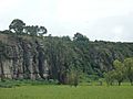
El Abra archaeological site
-
Salt Cathedral


.JPG)
.JPG)


See also
 In Spanish: Zipaquirá para niños
