
Lake Tauca facts for kids
Quick facts for kids Lake Tauca |
|
|---|---|
| Lake Pocoyu | |

Satellite image of the Altiplano. The green, brown and white surfaces in the lower right quadrant of the image are Lake Poopó, Salar de Coipasa and Salar de Uyuni, respectively. The blue surface at centre top is Lake Titicaca
|
|

Lake Tauca
Location in Bolivia
|
|
| Location | Andes, South America |
| Coordinates | 20°S 68°W / 20°S 68°W |
| Type | Former lake Pleisto- Holocene glacial lake 72,600–7200 BP |
| Part of | Altiplano |
| Primary inflows | Glacial meltwater Desaguadero River, Río Grande de Lipez, Lauca River |
| Primary outflows | Potentially Pilcomayo River |
| Basin countries | Bolivia, Chile, Peru |
| Surface area | 48,000–80,000 km2 (19,000–31,000 sq mi) |
| Average depth | 100 m (330 ft) |
| Max. depth | 142 m (466 ft) |
| Water volume | 1,200–3,810 km3 (290–910 cu mi) |
| Salinity | 20–90 g/L (0.00072–0.00325 lb/cu in) |
| Surface elevation | 3,660–3,770 m (12,010–12,370 ft) |
| Max. temperature | 10 °C (50 °F) |
| Min. temperature | 2 °C (36 °F) |
Lake Tauca was a huge ancient lake that once covered large parts of the Altiplano in Bolivia. The Altiplano is a very high plateau in the Andes mountains of South America. Lake Tauca is also known as Lake Pocoyu. This name comes from the lakes and salt flats that exist there today: Lake Poopó, Salar de Coipasa, and Salar de Uyuni.
This ancient lake was enormous, covering an area between 48,000 to 80,000 square kilometres (19,000 to 31,000 sq mi). That's bigger than some countries! Its water levels changed over time, sometimes reaching as high as 3,800 metres (12,500 ft) above sea level. The lake was also quite salty. Water flowed into Lake Tauca from sources like Lake Titicaca and melting glaciers. The huge weight of the lake even pushed down the land beneath it.
Lake Tauca was home to tiny living things called Diatoms, as well as plants and animals. Sometimes, these living things formed special reef knolls, which are like small underwater hills.
Scientists believe Lake Tauca started to grow about 18,500 years ago. It reached its biggest size around 16,000 and 14,500 years ago. Then, about 14,200 years ago, the water levels dropped. They rose again for a while, until about 11,500 years ago. Some researchers think the lake might have lasted until 8,500 years ago. When the lake dried up, it left behind the huge salt flats we see today, like the Salar de Uyuni.
Lake Tauca was one of several ancient lakes that formed on the Altiplano. Other old lakes in the area include Lake Escara, Ouki, Salinas, Minchin, Inca Huasi, and Sajsi. Sometimes, Sajsi is considered part of Lake Tauca. Scientists also divide Lake Tauca into an earlier phase (called Ticaña) and a later phase (called Coipasa).
Lake Tauca formed because the air over the Altiplano became colder and there was more rain. This might have happened because of changes in global wind patterns and stronger easterly winds. At first, people thought melting glaciers filled the lake. However, glaciers alone wouldn't have provided enough water for such a massive lake. The lake's growth happened at the same time as glaciers in the Andes were getting bigger.
Contents
What Was Lake Tauca Like?


A High Plateau Lake
Lake Tauca was located on the Altiplano, a high plateau in the Andes mountains. This plateau is very high, usually between 3,800 to 4,000 metres (12,500 to 13,100 ft) above sea level. The Andes are the world's longest mountain chain. They formed millions of years ago. The Altiplano is surrounded by eastern and western mountain ranges, which can reach 6,500 metres (21,300 ft) high.
The eastern mountains create a "rain shadow" over the Altiplano. This means they block rain from reaching the area, making it usually dry. However, during the summer, winds from the Amazon bring moisture, causing some rain. The amount of rain and temperature changes from north to south. It's warmer and wetter in the north and colder and drier in the south. Even with some rain, more water evaporates than falls as rain.
The land on the Altiplano is mostly made of sediments from ancient lakes and rivers. Today, the Altiplano has Lake Titicaca, which is about 8,800 square kilometres (3,400 sq mi) in size. It also has large salt flats like the Salar de Uyuni (10,000 square kilometres (3,900 sq mi)) and the Salar de Coipasa (2,500 square kilometres (970 sq mi)). Lake Titicaca and the southern salt flats are usually separate, but they can connect through the Rio Desaguadero when Titicaca's water level is high.
Scientists first thought the Altiplano was covered by lakes in 1882. Lakes like Tauca usually formed when temperatures were lower.
Size and Shape
Lake Tauca was much larger than today's Lake Titicaca. It stretched for over 600 kilometres (370 mi) and covered the areas of present-day Lake Poopó, Salar de Uyuni, and Salar de Coipasa. It was the biggest ancient lake in the Altiplano in the last 120,000 years, similar in size to Lake Michigan in North America.
Scientists have different ideas about its exact size, but most agree it was huge. Estimates for its surface area range from 33,000 to 80,000 square kilometres (13,000 to 31,000 sq mi). Its water depth reached between 110–120 metres (360–390 ft). This means the water level was about 140 metres (460 ft) higher than the Salar de Uyuni is today.
The land under the lake actually sank because of the immense weight of the water. When the lake dried up, the land slowly rose again. This is called isostatic rebound.
Later, the lake had a lower water phase called Ticaña. The drop from the main Tauca phase was sudden. Another late phase, called Coipasa, had a water level of about 3,660 metres (12,010 ft) and covered around 32,000 square kilometres (12,000 sq mi).
Lake Tauca and earlier lakes left behind clues like eroded benches (flat areas on hillsides), fan deltas (where rivers met the lake), and layers of lake sediments. The ridge between Salar de Uyuni and Salar de Coipasa was a peninsula in the lake. Places like San Agustín, San Cristóbal, and Colcha were islands.
Today's cities of Oruro and Uyuni are in areas that were once under Lake Tauca. When the lake dried up, it left behind a lot of fine sediments. This "restocked" the land, meaning there was more dust to be carried by winds to places like Patagonia.
-
Salar de Ascotan
-
Salar de Carcote
-
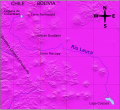
The course of the Lauca River
-
Tata Sabaya with the landslide to the left
-
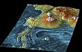
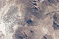
3D geography of Salar de Uyuni, remainder of Lake Tauca


Water and Salt

Lake Tauca held a huge amount of water, estimated to be between 1,200 cubic kilometres (290 cu mi) and 3,810 cubic kilometres (910 cu mi). This much water could have filled up in just a few centuries. The water temperature in the lake ranged from about 2 to 10 °C (36 to 50 °F).
The lake was deep and salty. The saltiness increased as the lake changed from the Tauca phase to the Coipasa phase. The main salts were NaCl (table salt) and sodium sulfate. Salt concentrations could have been as high as 60 to 90 grams per litre (0.0022 to 0.0033 lb/cu in). For comparison, ocean water is about 35 g/L. Some of this salt soaked into the ground beneath the lake, forming underground water reserves called aquifers.
Melting glaciers likely added a lot of water to Lake Tauca. Water also flowed from Lake Titicaca through the Rio Desaguadero. Some studies suggest that between 70% and 83% of Lake Tauca's water came from Lake Titicaca. This would have been 8 to 30 times more water than the Desaguadero River carries today! However, other research suggests Lake Titicaca contributed much less, perhaps only one-third or even as little as four percent of Tauca's water. About 53% of Lake Tauca's water came from the Eastern Cordillera mountains.
The lake was also fed by rivers like the Río Grande de Lipez and the Río Lauca. The total area that collected water for the lake was about 200,000 square kilometres (77,000 sq mi). If the lake reached its highest levels, it might have even drained into the Pilcomayo River, which eventually flows into the Atlantic Ocean.
Scientists now believe that increased rainfall or less evaporation (or both) were more important for forming the lake than just melting glaciers. Melting glaciers alone wouldn't have been enough. The lake itself might have helped increase rainfall by affecting local winds.
The evaporation rate from Lake Tauca was enormous, similar to the amount of water flowing out of major rivers like the Nile or Rhine today. Less than half of this evaporated water returned to the lake as rain.
Glaciers and ice were probably present around the lake. At places like Tunupa, river deltas formed where the lake met the glaciers. Glaciers reached their biggest size just before the lake was at its highest. Their melting then added water to the lake.
Lake Tauca left behind thick layers of sediments, up to 5 metres (16 ft) deep, in the southern Altiplano. It also left tufa deposits, which are a type of rock formed by minerals in water. These sediments contain various minerals like clay, feldspar, and quartz.
Life in the Lake

Scientists have found small amounts of pollen in the sediments left by Lake Tauca. This pollen tells us about the plants that lived around the lake. Some plants, like Polylepis, might have grown well in the lake's salty conditions. More Polylepis and Acaena pollen appeared towards the end of Lake Tauca's time.
The lake was deep enough for tiny floating organisms called planktonic diatoms to live there. The most common one was Cyclotella choctawatcheeana. Other diatoms, like Denticula subtilis and Achnanthes brevipes, were also found.
Fossils of snails (called gastropods) and tiny crustaceans (called ostracods) have been found along the lake's old shorelines. Plants like Myriophyllum and Isoetes also lived in the shallow areas near the shore.
Algae grew in the lake and formed special structures called reef knolls, which are made of carbonate rocks. These were like small reefs and grew in different stages. Some of these dome-shaped bioherms were up to 4 metres (13 ft) tall. They often grew around rocks or other objects sticking out of the water. The water above these tufa deposits was probably less than 20 metres (66 ft) deep.
How We Know About Lake Tauca
Scientists have been studying ancient lake deposits on the Altiplano since 1861. Early researchers, like John B. Minchin in 1882, noticed crusts around Lake Poopo and the salt flats. He suggested a huge lake, covering 120,000 square kilometres (46,000 sq mi), left these crusts. The name "Lake Minchin" was later given to this idea.
Scientists identify these ancient lakes by looking at lake terraces (old shorelines), sediments (layers of mud and sand left by the lake), bioherms (the rock structures formed by algae), and drill cores (samples taken from deep underground).
Lakes Before Tauca
Before Lake Tauca, other large lakes existed in the Altiplano. These include Ouki (about 120,000–98,000 years ago), Salinas (95,000–80,000 years ago), Inca Huasi (around 46,000 years ago), and Sajsi (24,000–20,500 years ago). Sometimes, Inca Huasi and Minchin are thought to be the same lake phase.
Lake Escara
Escara might be the oldest lake cycle on the Altiplano. Its water levels reached 3,780 metres (12,400 ft) high, possibly as big as Lake Tauca. Thick deposits, up to 8 metres (26 ft) deep, were left by this lake. Escara is dated to about 191,000 years ago.
Lake Minchin
A wet period about 46,000-36,000 years ago is called "Lake Minchin." This period also led to a large body of water on the Altiplano, where Lake Tauca would later form. During this time, many lakes filled up in the Andes, and moisture increased in the Amazon region. Like Lake Tauca, Lake Minchin is linked to a very cold period called the last glacial maximum.
The name "Lake Minchin" has been used in many ways, which can be confusing. Some scientists have suggested we stop using the name because of this confusion.
When Did Lake Tauca Exist?

Before Lake Tauca, there was a dry period. Then, around 28,000 years ago, water levels started to rise in Lake Titicaca, about two thousand years before Lake Tauca began.
The age of Lake Tauca is estimated to be from 72,600 to 7200 years ago. Scientists use methods like radiocarbon dating of shells and algae structures to figure this out. The shorelines of Lake Tauca formed over periods longer than a century.
Early research in 1978 suggested Lake Tauca existed between 12,500 and 11,000 years ago. Later studies in the 1990s and 2000s refined these dates. For example, research in 2011 suggested the lake began to rise about 18,500 years ago. It slowly rose to 3,670 metres (12,040 ft) by 17,500 years ago, then quickly rose to 3,760 metres (12,340 ft) by 16,000 years ago. The lake was at its highest point from 16,000 to 14,500 years ago.
Around 14,200 years ago, the lake level started to drop. By 13,800 years ago, it was much lower. The Coipasa phase, a later stage of the lake, began before 13,300 years ago and reached its peak around 12,500 years ago. The Coipasa lake had almost completely disappeared by 11,500 years ago.
Lake Tauca is sometimes divided into three phases: Tauca proper, Ticaña, and Coipasa. The Ticaña phase was a time when the water level dropped significantly. The drying of Lake Tauca during the Ticaña lowstand might be linked to a climate period called the Bølling–Allerød. During this time, Lake Titicaca might have dropped below its outflow, cutting off water to Lake Tauca. Rising temperatures and less rain also contributed to the lake drying up.
As the lake dried, Lake Poopó would have been separated first because the land connecting it to the rest of Lake Tauca was relatively shallow. Coipasa and Uyuni would have stayed connected longer. By the time of the Antarctic Cold Reversal, Lake Tauca was dry.
When Lake Tauca dried up, it left behind the world's largest salt flat, the Salar de Uyuni. About 10 metres (33 ft) of salt material was left there.
What Was the Climate Like?

Scientists believe that for Lake Tauca to form, summer rainfall would have needed to increase by about 315 millimetres (12.4 in) and temperatures would have dropped by about 3 °C (37 °F). Other estimates suggest a temperature decrease of 5 to 7 °C (41 to 45 °F) and a 20-75% increase in rain. More recent research suggests temperatures were about 2.9 °C (37.2 °F) colder than today, and rainfall was 130% higher, about 900 millimetres per year (1.1 in/Ms).
The formation of Lake Tauca is linked to a southward shift of the Intertropical Convergence Zone (ITCZ). This is a band of low pressure near the equator that affects rainfall. This shift brought more moisture from the east into the Altiplano. More clouds also helped by reducing how much water evaporated from the lake.
During the time of Lake Tauca, between 17,000 and 11,000 years ago, glaciers in the Andes also grew bigger. This means the climate was colder and wetter. The maximum size of glaciers in southern Bolivia happened around 13,300 years ago, at the same time as Lake Tauca was at its highest. The melting of these glaciers as they retreated also added water to the lake.
How Lake Tauca Affected the Environment

The formation and disappearance of Lake Tauca was a huge event that brought several thousand years of wetter climate to the region. This period is known as the Central Andean Pluvial Event (CAPE). During this time, the Atacama desert, usually very dry, became much wetter. Oases (fertile spots in the desert) formed, and people started to settle in the area.
The wet period of Lake Tauca also allowed early humans (called Paleoindians) to settle in South America. The first people in the Lake Tauca region appeared towards the end of the Ticaña phase. The Coipasa phase, when the lake was still present, saw humans fully establish themselves in the region and spread into northwestern Argentina. When the ancient lakes dried up, these early human settlements in the desert often ended.
Lake Tauca and the lakes before it left behind layers of salt called evaporite deposits. In the Salar de Uyuni, these layers can be up to 6 metres (20 ft) thick. The salts are constantly washed and re-deposited by rain, which makes the surface of the salt flats incredibly flat and smooth.
The drying of these ancient lakes also separated populations of amphibians and fish. For example, similar fish species in different areas today are thought to have been connected by Lake Tauca. The Altiplano had much more life during the Tauca period, including now-extinct deer and horses.
Images for kids
-
Salar de Ascotan
-
Salar de Carcote
-
The course of the Lauca River
-
Tata Sabaya with the landslide to the left
-
3D geography of Salar de Uyuni, remainder of Lake Tauca
See also
 In Spanish: Lago Tauca para niños
