
Chía, Cundinamarca facts for kids
Quick facts for kids
Chía
|
|||
|---|---|---|---|
|
Municipality and city
|
|||
   _(47143617582).jpg) Top: University of La Sabana, Second: Marroquin Castle, Third: Puente del Común, Four: Downtown Chía
|
|||
|
|||
| Nickname(s):
City of the Moon
|
|||

Location of the town and municipality of Chia in Cundinamarca Department.
|
|||

Chía, Cundinamarca
Location in Colombia
|
|||
| Country | Colombia | ||
| Department | Cundinamarca | ||
| Province | Central Savanna | ||
| Founded | 24 March 1537 | ||
| Founded by | Gonzalo Jiménez de Quesada | ||
| Area | |||
| • Municipality and city | 80.16 km2 (30.95 sq mi) | ||
| • Urban | 19.16 km2 (7.40 sq mi) | ||
| Elevation | 2,564 m (8,412 ft) | ||
| Population
(2020 est.)
|
|||
| • Municipality and city | 149,570 | ||
| • Density | 1,865.89/km2 (4,832.6/sq mi) | ||
| • Urban | 124,309 | ||
| • Urban density | 6,487.9/km2 (16,804/sq mi) | ||
| Demonym(s) | Chiense or Chiano | ||
| Time zone | UTC-5 | ||
| Website | Official website: http://www.chia-cundinamarca.gov.co/ | ||


Chía is a lively city and municipality in Cundinamarca, Colombia. It's located just 10 kilometers (about 6 miles) north of Bogotá, Colombia's capital. Because it's so close to Bogotá, Chía has become a popular suburb where many people live and work.
This city has a long and interesting history, going back to before Christopher Columbus arrived. Chía is also famous for its delicious food and many different restaurants. You can also find the Universidad de la Sabana here, which is one of the best universities in Colombia.
Contents
What Does the Name Chía Mean?
The name "Chía" comes from the Chibcha language or Muisca language. It means "Moon." The Moon was very important to the ancient Muisca as both a star and a goddess. They even built a special temple in her honor in their old town.
A Look Back at Chía's History
Chía was first home to native groups during the Herrera Period. Later, the Muisca lived here. It was an important place for them, especially for worshipping the Moon goddess Chía.
On March 24, 1537, Spanish explorers led by Gonzalo Jiménez de Quesada arrived. They took control of the town.
In 1781, a big protest happened called the Revolt of the Comuneros. The rebels marched towards Bogotá. They stopped near Chía to cross the Bogotá River at a place now called the Bridge of the Commoners (Puente del Común). Here, the leader of the Spanish government signed agreements with the rebels. However, once the rebels went home, the agreements were canceled. Many people believe that Bogotá will eventually grow so much that it will join with Chía, just like it did with other nearby towns.
Where is Chía Located?
Chía shares its borders with several other towns and cities:
- To the north, it borders Cajicá.
- To the south, it borders Bogotá neighborhoods like Usaquén and Suba.
- To the west, it borders Tabio and Tenjo.
- To the southwest, it borders Cota.
- To the east, it borders Sopó.
- To the southeast, it borders La Calera.
Quick Facts About Chía
- Market Day: Sundays are when the local market is held.
- Average Temperature: The weather is usually around 14 °C (57 °F).
- DANE Code: 25175 (This is a special code used for towns in Colombia).
Fun Places to Visit in Chía
Chía has many interesting spots for visitors and locals alike:
- Marroquín Castle (El Castillo Marroquín): This amazing building was built in 1898. It's a cultural landmark and is used for many different events and meetings.
- Puente del Común: This historic bridge is where important events from the past took place.
- Shopping Malls: You can find modern shopping centers like Centro Comercial Consteación, Chía Mall (Centro-Chía), and Fontanar Mall (Centro Comercial Fontanar). They are great for shopping and entertainment.
- Andrés Carne de Res: This is a very famous and unique restaurant known for its lively atmosphere and delicious food.
- Iglesia la Valvanera: A beautiful church in the area.
- Biblioteca Publica Municipal HOQABIGA: This is the public library, a great place to read and learn.
- Parque Santander: A local park where you can relax and enjoy the outdoors.
- La Montaña del Oso (The Bear Mountain): This is a natural park located high up in the mountains, about 3200 meters (10,500 feet) above sea level. You can go on guided walks and even camp there.
- Chapel of Our Lady of Valvanera (Capilla de Nuestra Señora de la Valvanera): This chapel sits on top of a western hill in Chía. You can see it from almost anywhere in the town! You can walk up steps to reach it or use two roads. On Sundays, church services are held here. From the balcony, you get an amazing view of Chía. The roads around the hill are also popular for mountain biking.
Sports and Recreation
Chía offers several places for sports and activities:
- Coliseo de la Luna: This is a large sports arena that can hold 8,000 people. It's the home court for the basketball team Cóndores de Cundinamarca.
- Sports Unit "Rio Frio": Another facility for various sports.
- Olympic Village: A complex dedicated to sports training and events.
- BMX Track "Iván de Jesús Barrientos": A special track for BMX biking.
Chía's Climate
| Climate data for Chía (Guaymaral Airport), elevation 2,560 m (8,400 ft), (1971–2000) | |||||||||||||
|---|---|---|---|---|---|---|---|---|---|---|---|---|---|
| Month | Jan | Feb | Mar | Apr | May | Jun | Jul | Aug | Sep | Oct | Nov | Dec | Year |
| Mean daily maximum °C (°F) | 20.8 (69.4) |
20.9 (69.6) |
20.4 (68.7) |
20.1 (68.2) |
19.5 (67.1) |
18.7 (65.7) |
18.4 (65.1) |
18.9 (66.0) |
19.3 (66.7) |
19.8 (67.6) |
20.2 (68.4) |
20.4 (68.7) |
19.8 (67.6) |
| Daily mean °C (°F) | 13.0 (55.4) |
13.3 (55.9) |
13.6 (56.5) |
13.8 (56.8) |
13.6 (56.5) |
13.1 (55.6) |
12.8 (55.0) |
13.0 (55.4) |
13.1 (55.6) |
13.2 (55.8) |
13.2 (55.8) |
13.0 (55.4) |
13.2 (55.8) |
| Mean daily minimum °C (°F) | 6.8 (44.2) |
7.5 (45.5) |
8.5 (47.3) |
9.2 (48.6) |
9.3 (48.7) |
9.1 (48.4) |
8.6 (47.5) |
8.3 (46.9) |
8.2 (46.8) |
8.6 (47.5) |
8.9 (48.0) |
7.7 (45.9) |
8.4 (47.1) |
| Average precipitation mm (inches) | 28.8 (1.13) |
47.9 (1.89) |
65.4 (2.57) |
100.5 (3.96) |
89.9 (3.54) |
54.1 (2.13) |
39.4 (1.55) |
41.2 (1.62) |
65.7 (2.59) |
99.1 (3.90) |
85.0 (3.35) |
45.7 (1.80) |
762.7 (30.03) |
| Average precipitation days | 8 | 10 | 12 | 16 | 20 | 17 | 16 | 16 | 14 | 17 | 17 | 12 | 176 |
| Average relative humidity (%) | 75 | 75 | 76 | 79 | 79 | 78 | 77 | 76 | 77 | 79 | 79 | 77 | 77 |
| Mean monthly sunshine hours | 167.4 | 132.9 | 120.9 | 99.0 | 105.4 | 99.0 | 117.8 | 111.6 | 102.0 | 105.4 | 123.0 | 167.4 | 1,451.8 |
| Mean daily sunshine hours | 5.4 | 4.7 | 3.9 | 3.3 | 3.4 | 3.3 | 3.8 | 3.6 | 3.4 | 3.4 | 4.1 | 5.4 | 4.0 |
| Source: Instituto de Hidrologia Meteorologia y Estudios Ambientales | |||||||||||||
More Pictures of Chía
-
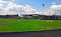
Football pitch
-
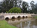
Puente El Común
-

La Caro Railway Station


See Also
 In Spanish: Chía (Colombia) para niños
