
Chiquinquirá facts for kids
Quick facts for kids
Chiquinquirá
|
|||
|---|---|---|---|
|
Municipality and town
|
|||

View of Chiquinquirá
|
|||
|
|||

Location of the municipality and town of Chiquinquirá in the Boyacá Department of Colombia.
|
|||

Chiquinquirá
Location in Colombia
|
|||
| Country | |||
| Department | Boyacá Department | ||
| Province | Western Boyacá Province | ||
| Founded | never | ||
| Area | |||
| • Municipality and town | 165 km2 (64 sq mi) | ||
| • Urban | 6.38 km2 (2.46 sq mi) | ||
| Elevation | 2,556 m (8,386 ft) | ||
| Population
(2018 census)
|
|||
| • Municipality and town | 56,054 | ||
| • Density | 339.7/km2 (879.9/sq mi) | ||
| • Urban | 49,016 | ||
| • Urban density | 7,683/km2 (19,898/sq mi) | ||
| Demonym(s) | Chiquinquireño | ||
| Time zone | UTC-5 (Colombia Standard Time) | ||
| Postal code |
154640-49
|
||
| Area code(s) | 57 + 8 | ||
| Website | Official website: http://www.chiquinquira-boyaca.gov.co/ | ||


Chiquinquirá is a town and municipality in the country of Colombia. It is located in the Boyacá Department, which is part of the Western Boyacá Province. The town is about 115 kilometers (71 miles) north of Bogotá, the capital city. Chiquinquirá sits high up, about 2,556 meters (8,386 feet) above sea level. The average temperature there is around 14°C (58°F) throughout the year.
Contents
What's in a Name?
The name Chiquinquirá comes from the Chibcha language. It means "Place of swamps covered with fog." This name tells us a bit about the area's natural features.
Town Layout and Religion
Chiquinquirá has two main parts: the urban area, which is the town itself, and the rural area, which surrounds the town. The urban area has about 40 neighborhoods. The rural area is divided into 17 smaller zones.
This town is very important for religious reasons. It is home to the Basílica de Chiquinquirá. Inside this church, you can find the image of the Virgen de Chiquinquirá. She is considered the patroness saint of Colombia. Many people visit Chiquinquirá each year because of its religious significance.
A Look at History
Before the Spanish arrived, the area of Chiquinquirá was home to the Muisca people. It was an important place in the Chiquinquirá Valley. The town was led by its own independent cacique (a local chief) and was part of the larger Muisca Confederation. Interestingly, Chiquinquirá was never officially "founded" as a municipality in the traditional way.
In November 1967, Chiquinquirá faced a sad event. Many people, including children, became very sick after eating bread made with flour that had accidentally been mixed with a harmful substance. This event was a big tragedy for the town.
Climate
| Climate data for Chiquinquirá (Esclusa Tolon), elevation 2,545 m (8,350 ft), (1971–2000) | |||||||||||||
|---|---|---|---|---|---|---|---|---|---|---|---|---|---|
| Month | Jan | Feb | Mar | Apr | May | Jun | Jul | Aug | Sep | Oct | Nov | Dec | Year |
| Mean daily maximum °C (°F) | 19.5 (67.1) |
19.6 (67.3) |
19.6 (67.3) |
19.5 (67.1) |
19.2 (66.6) |
18.6 (65.5) |
18.3 (64.9) |
18.5 (65.3) |
18.8 (65.8) |
19.0 (66.2) |
19.3 (66.7) |
19.3 (66.7) |
19.1 (66.4) |
| Daily mean °C (°F) | 12.1 (53.8) |
13.1 (55.6) |
13.5 (56.3) |
13.8 (56.8) |
13.8 (56.8) |
13.2 (55.8) |
12.7 (54.9) |
12.7 (54.9) |
13.0 (55.4) |
13.4 (56.1) |
13.6 (56.5) |
13.2 (55.8) |
13.2 (55.8) |
| Mean daily minimum °C (°F) | 6.5 (43.7) |
7.3 (45.1) |
8.1 (46.6) |
9.3 (48.7) |
9.3 (48.7) |
8.1 (46.6) |
7.2 (45.0) |
7.1 (44.8) |
7.5 (45.5) |
8.9 (48.0) |
9.1 (48.4) |
7.6 (45.7) |
8.0 (46.4) |
| Average precipitation mm (inches) | 36.6 (1.44) |
49.0 (1.93) |
84.6 (3.33) |
114.8 (4.52) |
94.6 (3.72) |
65.6 (2.58) |
57.6 (2.27) |
59.0 (2.32) |
82.7 (3.26) |
137.0 (5.39) |
118.6 (4.67) |
58.7 (2.31) |
958.8 (37.75) |
| Average precipitation days | 9 | 11 | 15 | 18 | 17 | 14 | 13 | 13 | 15 | 20 | 18 | 14 | 178 |
| Average relative humidity (%) | 75 | 76 | 77 | 78 | 77 | 75 | 73 | 73 | 74 | 78 | 79 | 77 | 76 |
| Mean monthly sunshine hours | 201.5 | 163.9 | 173.6 | 138.0 | 139.5 | 135.0 | 170.5 | 161.2 | 150.0 | 145.7 | 144.0 | 186.0 | 1,908.9 |
| Mean daily sunshine hours | 6.5 | 5.8 | 5.6 | 4.6 | 4.5 | 4.5 | 5.5 | 5.2 | 5.0 | 4.7 | 4.8 | 6.0 | 5.2 |
| Source: Instituto de Hidrologia Meteorologia y Estudios Ambientales | |||||||||||||
Geology
A type of rock formation called the Chiquinquirá Sandstone is named after this town. This shows that the area has interesting geological features.
Gallery
-

Cultural centre
-
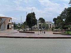
David Guarín Park
-
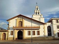
Church
-
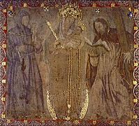
Painting of the Virgin Mary


See also
 In Spanish: Chiquinquirá para niños
