
Mayon Volcano facts for kids
Quick facts for kids Mayon |
|
|---|---|
|
|

Mayon Volcano in 2020
|
|
| Highest point | |
| Elevation | 2,463 m (8,081 ft) |
| Prominence | 2,447 m (8,028 ft) |
| Listing |
|
| Geography | |
|
Lua error in Module:Location_map at line 530: Unable to find the specified location map definition: "Module:Location map/data/Philippines Albay" does not exist.
|
|
| Country | Philippines |
| Region | Bicol Region |
| Province | Albay |
| Cities and municipalities |
List
Camalig
Daraga Guinobatan Legazpi Ligao Malilipot Santo Domingo Tabaco |
| Geology | |
| Age of rock | > 20,000 years |
| Mountain type | Stratovolcano |
| Volcanic arc/belt | Bicol Volcanic Chain |
| Last eruption | Ongoing |
| Climbing | |
| First ascent | Scotsmen Paton & Stewart (1858) |
Mayon (also called Mount Mayon or Mayon Volcano) is a very active stratovolcano in the Albay province of the Bicol Region in the Philippines. It is a popular place for tourists. Mayon is famous for its "perfect cone" shape, which means it looks very symmetrical. Many people in the Philippines also consider it a sacred place.
This volcano and the land around it became the first national park in the Philippines on July 20, 1938. Later, in 2000, it was renamed the Mayon Volcano Natural Park. In 2016, UNESCO declared it part of the Albay Biosphere Reserve. Efforts are now being made to make it a World Heritage Site.
Mayon is the most active volcano in the Philippines. The Philippine Institute of Volcanology and Seismology (PHIVOLCS) constantly watches its activity from their office on Ligñon Hill, about 12 kilometers (7.5 miles) from the top.
Contents
Where is Mayon Volcano Located?

Mayon is the most important landmark and the highest point in the province of Albay and the entire Bicol Region. It rises 2,463 meters (8,081 feet) from the shores of Albay Gulf, which is about 10 kilometers (6.2 miles) away.
The volcano is shared by eight cities and towns: Legazpi, Daraga, Camalig, Guinobatan, Ligao, Tabaco, Malilipot, and Santo Domingo. They divide the volcano like slices of a pie on a map.
How Mayon Volcano Was Formed
Mayon is a classic stratovolcano, which means it's a tall, cone-shaped volcano built up by many layers of hardened lava, ash, and rocks. It has a small crater at its very top. Mayon is known for having one of the most perfectly shaped cones in the world.
The volcano's unique curved shape comes from a balance between erosion (wearing away by wind and water) and eruptions. The upper parts of the volcano are very steep, with an average slope of 75%. The lower parts are much gentler, with an average slope of only 3%. The crater at the top is about 250 meters (820 feet) wide.
Mayon is part of the Pacific Ring of Fire, a large area around the Pacific Ocean where many earthquakes and volcanic eruptions happen. It is located on the southeast side of Luzon, a large island in the Philippines. The volcanoes in this area, including Mayon, are linked to the movement of the Philippine Plate under another plate.
Scientists have found that soils from Mayon contain special bacteria that might help create new antibiotics and anti-cancer medicines.
Major Eruptions of Mayon Volcano
Mayon is the most active volcano in the Philippines. It has erupted over 52 times in the last 500 years! The first recorded eruption was in 1616.
The 1814 Eruption: A Deadly Event

Mayon's most destructive eruption happened on February 1, 1814. Lava flowed, but the volcano also shot out dark ash and rocks (called tephra). The town of Cagsawa was buried under this material. Trees burned, and rivers were damaged. Ash piled up to 9 meters (30 feet) deep in some areas.
About 1,200 people died in Cagsawa, making it the deadliest eruption in Mayon's history. This eruption, along with a huge eruption of Mount Tambora in Indonesia in 1815, added a lot of ash to the atmosphere. This may have contributed to the "Year Without a Summer" in 1816, when temperatures dropped worldwide.
The 1897 Eruption: Seven Days of Fire

Mayon's longest continuous eruption began on June 23, 1897, and lasted for seven days. Lava flowed 11 kilometers (6.8 miles) eastward, burying the village of Bacacay under 15 meters (49 feet) of lava. In Santo Domingo, 100 people died from steam and falling hot rocks. Other villages were also destroyed. Black ash clouds traveled as far as 160 kilometers (100 miles) away. More than 400 people died in this event.
Recent Eruptions: 1984 and 1993

In 1984, over 73,000 people were moved to safety before the eruption, so no one died. However, in 1993, fast-moving hot gas and rock flows (pyroclastic flows) killed 79 people, mostly farmers. About 50,000 people had to leave their homes.
The 2009–2010 Eruptions

In July 2009, scientists noticed more volcanic earthquakes, so they raised the alert level. On October 28, a small ash explosion happened, sending ash 600 meters (2,000 feet) above the crater.
By December 14, the volcano was very active, with many earthquakes and increased sulfur dioxide gas. The alert level was raised to 3. Early on December 15, a moderate ash explosion occurred, and lava started flowing down the volcano. About 20,000 people living near the volcano were moved to evacuation centers.

On December 20, the alert level went up to 4 because lava flow was increasing and sulfur dioxide emissions were high. Over 44,000 people were evacuated. The Philippine military blocked off the 8-kilometer (5-mile) danger zone to keep everyone safe. People had to spend Christmas and New Year in evacuation centers.
By January 2, 2010, the volcano's activity decreased, and the alert level was lowered to 3. Many families could return home. By January 13, the alert level was lowered again to 2, meaning a hazardous eruption was less likely.
The 2013 Phreatic Eruption

On May 7, 2013, Mayon had a sudden phreatic eruption. This type of eruption happens when hot water or steam explodes, not fresh magma. It lasted 73 seconds and produced ash, steam, and rocks. Ash clouds reached 500 meters (1,600 feet) high.
Sadly, this eruption killed five climbers: three Germans, one Spaniard, and a Filipino tour guide. Seven others were injured. Rescuers found their bodies, but the difficult terrain made it hard to bring them down. Even though this happened, the alert level stayed at 0 because there were no signs of more activity.
The 2018 Activity

On January 13, 2018, another phreatic eruption sent a grayish plume of steam and ash 2,500 meters (8,200 feet) high. Ash fell in nearby towns. This led to the alert level being raised to 2, and about 40,000 people were moved to safety.
On January 14, the alert level went up to 3 after more phreatic eruptions and rockfalls. A bright glow at the summit showed that new lava was forming and starting to flow. On January 16, the province declared a state of emergency as lava flows reached the edge of the 6-kilometer (3.7-mile) evacuation zone.
On January 22, the alert level was raised to 4 after Mayon shot out a 3-kilometer (1.9-mile) tall ash column. Schools were closed, and lava fountains, hot rock flows, and ash plumes were seen. The eruption was classified as a Strombolian eruption, which means it had explosive bursts of lava.
The volcano remained very active through January and February, staying at Alert Level 4. On March 6, the activity decreased, and the alert level was lowered to 3. By March 29, it was lowered to 2, meaning the eruption was over and the volcano was less restless.
2020 Crater Glow

On February 4, 2020, PHIVOLCS reported a glow inside Mayon's crater. This glow meant that magma was still present just below the surface. Even though it looked alarming, the volcano stayed at Alert Level 2. The alert level was lowered to 1 in July 2020, and then completely lifted in July 2021.
2022 and 2023 Activity
In October 2022, Mayon showed signs of increasing activity, including sulfur dioxide gas release and a faint crater glow. The alert level was raised to 2.
In June 2023, the alert level was again raised to 2 due to more rockfalls from the summit. On June 8, it was raised to Level 3, meaning a hazardous eruption was possible, and lava was actively flowing.
Dangerous Mudflows (Lahars)

Volcanic eruptions can create dangerous mudflows called lahars. These are like fast-moving rivers of mud, ash, and rocks. On November 30, 2006, a strong typhoon brought heavy rain. This rain mixed with the ash and boulders from Mayon's recent eruption, creating lahars that killed at least 1,266 people. Many people were buried under the mudslides.
A large part of Padang, a suburb of Legazpi City, was covered in mud up to the roofs of houses. Students in a dormitory were also killed as mudslides covered their building. Parts of Daraga were also destroyed, including the Cagsawa area, where the famous ruins from the 1814 eruption were partly buried again.
Similar lahars happened in 1766 and 1825, also caused by heavy rain after eruptions. The 1825 lahar in Cagsawa killed 1,500 people.
How Mayon Volcano is Monitored
Scientists use special equipment to keep an eye on Mayon. Three telemetric units are placed on the volcano's slopes. These send information to seven seismometers around the volcano. All this data goes to the Ligñon Hill observatory and the main PHIVOLCS office.
PHIVOLCS also uses other tools like electronic distance meters (EDMs) and precise leveling benchmarks to measure how the volcano's shape changes. They also use portable fly spectrometers to check the gases coming out of the volcano every day.
The Mythology of Mayon Volcano

Local legends say that Mayon Volcano grew from the burial place of two lovers, Magayon and Panganoron. Because of this, the ancient Bicolano people named the volcano after the legendary princess-heroine Daragang Magayon, which means "Beautiful Lady."
Over time, the volcano became known as the home of Gugurang, the supreme god of the Bicolano people. He chose Mayon as the place to keep the sacred fire of Ibalon. Many festivals and rituals are still held today that are connected to the volcano and its beautiful landscape.
Incidents and Accidents at Mayon
On February 23, 2023, a small plane crashed into the rocky slope of Mount Mayon. The plane had just taken off from Bicol International Airport and was climbing to 6,000 feet (1,800 meters) when it hit the volcano, about 16 kilometers (10 miles) north of the airport. The wreckage was found the next day near the crater. All four people on board, including two Australians, died in the crash.
Images for kids
-
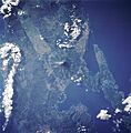
Mayon in satellite image

See also
 In Spanish: Monte Mayón para niños
