
Albay facts for kids
Quick facts for kids
Albay
|
|||
|---|---|---|---|
    .jpg) From top, left to right: Mayon Volcano, Daraga Church in Daraga, Tabaco Church in Tabaco, SM City Legazpi, Old Albay District
|
|||
|
|||
Nicknames:
|
|||
| Anthem: "Albay Forever" | |||

Location in the Philippines
|
|||
|
OpenStreetMap
|
|||
| Country | Philippines | ||
| Region | Bicol Region | ||
| Founded | April 3, 1574 | ||
| Capital and largest city |
Legazpi | ||
| Area | |||
| • Total | 2,575.77 km2 (994.51 sq mi) | ||
| Area rank | 52nd out of 82 | ||
| Highest elevation | 2,463 m (8,081 ft) | ||
| Population
(2020 census)
|
|||
| • Total | 1,374,768 | ||
| • Rank | 21st out of 81 | ||
| • Density | 533.7309/km2 (1,382.357/sq mi) | ||
| • Density rank | 12th out of 81 | ||
| Demonym(s) |
|
||
| Divisions | |||
| • Independent cities | 0 | ||
| • Component cities |
3
Legazpi
Ligao Tabaco |
||
| • Municipalities |
15
Bacacay
Camalig Daraga Guinobatan Jovellar Libon Malilipot Malinao Manito Oas Pio Duran Polangui Rapu-Rapu Santo Domingo Tiwi |
||
| • Barangays | 720 | ||
| • Districts | Legislative districts of Albay | ||
| Time zone | UTC+8 (PST) | ||
| IDD : area code | +63 (0)52 | ||
| ISO 3166 code | PH-ALB | ||
| Spoken languages | |||
| Website | albay |
||


Albay is a province in the Bicol Region of the Philippines. It is mostly located on the southeastern part of Luzon island. The capital and largest city is Legazpi. This city is also the main center for the entire Bicol Region. It sits near the famous Mayon Volcano.
In March 2016, Albay became part of the UNESCO World Network of Biosphere Reserves. This means it is a special place recognized for its unique nature and how people live with it.
Contents
Discovering Albay's Past
Early Beginnings
Long ago, even before the Spanish arrived, Albay was a busy place with its own culture. It was first called Ibat, then Libog. A wise old chief named Gat Ibal ruled Albay. He also started the old village of Sawangan, which is now part of Legazpi City. Stories from that time, like the epic "Bingi of Lawan," tell of powerful leaders.
Spanish Arrival and Changes
In 1569, Spanish explorers landed in a coastal area called Ibalon, which is now part of Sorsogon. From there, they explored further and founded towns like Camalig. In 1573, Juan de Salcedo explored the Bicol Peninsula and set up a settlement in Libon.
Later, a military engineer named Jose Maria Peñaranda became the leader of the province in 1834. He helped build public buildings, roads, and bridges. The Bicol peninsula was once one large province. But in 1636, it was split into two parts. Ibalon became a separate province. During the 17th century, groups from the southern Philippines sometimes raided the coastal areas of Albay.
On February 1, 1814, Mayon Volcano erupted very strongly. It destroyed five towns around its base. This eruption made the town of Cagsawa move to its current location, which is now Legazpi. In 1846, some islands like Masbate and Ticao were separated from Albay.
The Philippine Revolution
A man named Glicerio Delgado began revolutionary actions in Albay. He set up a base in the mountains of Guinobatan. He joined the Katipunan, a group fighting for independence. The Spanish military then created a local militia. Leaders like Mariano Riosa and Anacieto Solano helped organize these groups.
On September 22, 1898, a temporary revolutionary government was formed in Albay. Anacieto Solano became its provisional president.
American Influence
After the Spanish–American War, the United States took control of the Philippines. The Filipinos had declared their independence, but the Americans did not recognize it. During the Philippine–American War, American forces landed in Sorsogon and marched to capture Legazpi.
Even after a local government was set up in Albay in 1901, General Simeon Ola and his men continued to resist American rule. General Ola was later captured with many of his fighters.
World War II and Japanese Occupation
On December 12, 1941, during Second World War, Japanese forces invaded Legazpi. They occupied Albay Province. The local Philippine Constabulary tried to defend the area.
During the Japanese occupation, the Philippine Commonwealth Army and the Philippine Constabulary were active. Local Bicolano resistance groups, known as guerrillas, fought against the Japanese. They attacked enemy soldiers between 1942 and 1944. Many Bicolano guerrillas had to retreat before the Allied forces liberated the province in 1945.
Standing Up for Rights
The town of Oas in Albay was a place where people bravely spoke out against unfairness. Clemente Ragragio, a health inspector, was known for helping his community. He was honored for his work. He was sadly killed because he spoke out against unfairness. His murder was not investigated by the government at the time. He is now honored at the Bantayog ng mga Bayani (Monument of Heroes) in the Philippines. This monument remembers those who fought to bring back democracy.
Albay's Geography and Nature

Albay covers about 2,575.77 square kilometers. It is the 53rd largest province in the Philippines. Camarines Sur borders it to the north, and Sorsogon is to the south. To the northeast is Lagonoy Gulf. To the southwest is the Burias Pass, with Burias island nearby.
In 2016, a large area of 250,000 hectares in Albay was named a UNESCO Biosphere Reserve. This reserve is home to 182 types of land plants. About 46 of these plants are found only in the Philippines. Its ocean and coastal areas are also home to five of the world's seven kinds of marine turtles. It also has important mangrove, seagrass, and seaweed areas.
Mountains and Volcanoes
Albay is mostly mountainous, but it also has flat plains and valleys. In the eastern part, there is a line of volcanoes. These include Mount Malinao in Tiwi, Mount Masaraga, and the famous Mayon Volcano. Across Poliqui Bay are the Pocdol Mountains in Manito.
Mayon Volcano is a cone-shaped volcano that stands about 2,462 meters (8,077 feet) tall. It is the highest point in Albay and the most famous landmark in the entire Bicol Region. This active volcano is shared by eight towns and cities in Albay.
The western coast of Albay is also mountainous, but the mountains are not as tall as those in the east. Some of these mountains include Mount Catburawan in Ligao and Mount Pantao in Oas.
How Albay is Divided

Albay has 15 municipalities (towns) and three component cities. These cities are Legazpi, Ligao, and Tabaco.
- † Capital city
- ∗ Component city
- Municipality
| City or municipality | District | Population | ±% p.a. | Area | Density (2020) | Barangays | ||||||
|---|---|---|---|---|---|---|---|---|---|---|---|---|
| (2020) | (2015) | km2 | sq mi | /km2 | /sq mi | |||||||
| Bacacay 13°17′33″N 123°47′28″E / 13.2926°N 123.7912°E | 1st | 5.3% | 72,485 | 68,906 | +0.97% | 122.13 | 47.15 | 590 | 1,500 | 56 | ||
| 13°10′53″N 123°39′19″E / 13.1815°N 123.6552°E | Camalig | 2nd | 5.2% | 72,042 | 66,904 | +1.42% | 130.90 | 50.54 | 550 | 1,400 | 50 | |
| Daraga 13°08′52″N 123°42′47″E / 13.1478°N 123.7131°E | 2nd | 9.7% | 133,893 | 126,595 | +1.07% | 118.64 | 45.81 | 1,100 | 2,800 | 54 | ||
| Guinobatan 13°11′29″N 123°35′59″E / 13.1914°N 123.5997°E | 3rd | 6.2% | 85,786 | 82,361 | +0.78% | 244.43 | 94.37 | 350 | 910 | 44 | ||
| Jovellar 13°04′08″N 123°36′01″E / 13.0688°N 123.6002°E | 3rd | 1.3% | 17,795 | 17,308 | +0.53% | 105.40 | 40.70 | 170 | 440 | 23 | ||
| Legazpi 13°08′20″N 123°44′03″E / 13.1388°N 123.7343°E † | 2nd | 15.2% | 209,533 | 196,639 | +1.22% | 153.70 | 59.34 | 1,400 | 3,600 | 70 | ||
| Libon 13°17′59″N 123°26′18″E / 13.2998°N 123.4384°E | 3rd | 5.5% | 75,073 | 75,172 | −0.03% | 222.76 | 86.01 | 340 | 880 | 47 | ||
| Ligao 13°14′28″N 123°32′14″E / 13.2411°N 123.5373°E ∗ | 3rd | 8.6% | 118,096 | 111,399 | +1.12% | 246.75 | 95.27 | 480 | 1,200 | 55 | ||
| Malilipot 13°19′08″N 123°44′21″E / 13.3190°N 123.7393°E | 1st | 3.0% | 40,857 | 37,785 | +1.50% | 44.13 | 17.04 | 930 | 2,400 | 18 | ||
| Malinao 13°23′51″N 123°42′18″E / 13.3974°N 123.7049°E | 1st | 3.4% | 47,395 | 45,301 | +0.86% | 107.50 | 41.51 | 440 | 1,100 | 29 | ||
| Manito 13°07′28″N 123°52′11″E / 13.1244°N 123.8697°E | 2nd | 1.9% | 26,162 | 24,707 | +1.10% | 107.40 | 41.47 | 240 | 620 | 15 | ||
| Oas 13°15′27″N 123°30′01″E / 13.2575°N 123.5002°E | 3rd | 4.8% | 66,084 | 67,960 | −0.53% | 263.61 | 101.78 | 250 | 650 | 53 | ||
| Pio Duran 13°02′34″N 123°27′13″E / 13.0429°N 123.4536°E | 3rd | 3.6% | 49,070 | 46,693 | +0.95% | 133.70 | 51.62 | 370 | 960 | 33 | ||
| Polangui 13°17′37″N 123°29′03″E / 13.2937°N 123.4843°E | 3rd | 6.5% | 89,176 | 88,221 | +0.21% | 145.30 | 56.10 | 610 | 1,600 | 44 | ||
| Rapu-Rapu 13°11′10″N 124°07′33″E / 13.1862°N 124.1258°E | 2nd | 2.6% | 36,151 | 36,920 | −0.40% | 155.30 | 59.96 | 230 | 600 | 34 | ||
| Santo Domingo 13°14′14″N 123°46′39″E / 13.2371°N 123.7774°E | 1st | 2.7% | 37,765 | 34,967 | +1.48% | 51.22 | 19.78 | 740 | 1,900 | 23 | ||
| Tabaco 13°21′33″N 123°43′47″E / 13.3592°N 123.7298°E ∗ | 1st | 10.3% | 140,961 | 133,868 | +0.99% | 117.14 | 45.23 | 1,200 | 3,100 | 47 | ||
| Tiwi 13°27′25″N 123°40′47″E / 13.4569°N 123.6796°E | 1st | 4.1% | 56,444 | 53,120 | +1.16% | 105.76 | 40.83 | 530 | 1,400 | 25 | ||
| TOTAL | 1,374,768 | 1,314,826 | +0.85% | 2,574.91 | 994.18 | 530 | 1,400 | 720 | ||||
| † Provincial capital and component city Municipality ∗ Component city | ||||||||||||
People and Culture in Albay
Population and Homes
In 2020, Albay had 1,374,768 people. This makes it the 20th most populated province in the Philippines. There were about 208,640 households in 2007. Each household had an average of 5.22 people living in it.
Beliefs and Religions
Before the Spanish arrived, people in Albay had many gods and goddesses. For example, Gugurang was the supreme god who lived inside Mount Mayon. He protected a sacred fire. If people did bad things, Mayon Volcano would erupt as a warning. Asuang was an evil god who tried to steal the sacred fire.
Haliya was a masked goddess of moonlight. She protected Bulan, the god of the pale moon. Bulan was a handsome boy who could calm wild animals. Magindang was the god of the sea. He loved Bulan and chased him, which people believed caused the waves to rise. Bakunawa was a giant sea serpent. It was thought to cause eclipses by trying to swallow the sun and moon.
Catholicism in Albay

Today, Catholicism is the main religion in Albay. About 96% of people in Albay are Catholic. Every town celebrates a special fiesta for their patron saint.
Other Religions
Other religions in Albay include Iglesia ni Cristo (INC), which has about 2% of the population. There are also other Protestant churches like Baptist Church and Methodist. Some people are Evangelical Christians, Seventh-day Adventists, Mormons, Jehovah's Witnesses, and Islam followers.
Languages Spoken in Albay
Albay is home to many different languages from the Bicol Region. Most of these languages come from Albay itself. These include languages from the Albay Bikol group, like West Miraya, East Miraya, and Libon.
Rinconada Bikol is also spoken by some people in towns like Libon and Polangui. These towns are close to the border of Camarines Sur. Another main language is Central Bikol. This is the native language for people on the eastern coast of the Bicol Peninsula.
Most people in Albay also understand English and Filipino. These are often learned as second languages.
Albay's Economy and Industries
|
||||

Agriculture is the most important industry in Albay. Farmers grow crops like coconut, rice, sugar, and abacá. Making Handicrafts is a big way for people in rural areas to earn money. These small businesses are a large part of the province's economy.
Other ways people make a living include forestry, making cement, and producing paper. Making products from abacá, like Manila hemp, hats, bags, mats, furniture, and slippers, is a major source of income. The production of abaca fiber was very popular from the late 1800s until the American period. Fishing is also a main job for people living along the coasts.
Tourism is also important, especially because of the beautiful Mayon Volcano. Many visitors come to Albay, bringing income to the province. In 2013, Albay had over 339,000 foreign tourists.
In December 2023, during the Pili Fiesta, new ways to grow pili trees were introduced. The goal is to make pili a leading industry in the Bicol Region.
Albay's Government
Albay has three congressional districts. These districts cover its 15 municipalities and 3 cities. Each district has a representative in the national government.
| District | Representative | City or municipality | District population (2020) |
|---|---|---|---|
| 1st District (Coastal District) | Krisel L. Luistro |
|
395,907 |
| 2nd District (Capital District) | Carlos A. Loria |
|
477,781 |
| 3rd District (Miraya District) | Raymond E. Salceda |
|
501,080 |
Getting Around Albay
Roads for Travel
Albay has about 383.22 kilometers (238.12 miles) of national roads. Most of these roads are paved with asphalt. The Maharlika Highway is the main road connecting Albay to other provinces. Most cities and towns are linked by national roads. However, Rapu-Rapu is an island and does not have road connections to the mainland.
There are plans for a new expressway called Toll Road 5. This 420-kilometer (260-mile) road will connect Lucena City in Quezon to Matnog in Sorsogon. This project aims to make travel much faster.
Water Transportation

Albay is a key place for moving goods and people by sea. It has several important ports. These include Tabaco International Port, Legazpi National Port, Pio Duran Provincial Port, and Pantao Regional Port.
Air Travel
If you want to fly to Albay, you will arrive at the Bicol International Airport. This airport is in Daraga, which is next to Legazpi City. It is the main way to fly into the province from places like Manila and Cebu City. The older Legazpi Airport is no longer in use.
Train Services
Albay is also served by the Philippine National Railways (PNR). There is a train service that connects Albay to Naga in Camarines Sur. The train service to Manila, called the Mayon Limited, has been suspended since November 2012. There are four train stations in Albay: Polangui, Ligao, Guinobatan, and Legazpi.
Images for kids
-
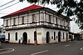
Manalang Ancestral House, a traditional Filipino house in Tabaco City.
-
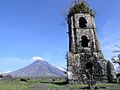
Cagsawa Ruins
-
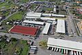
Aerial view of the Legazpi Grand Central Terminal
-
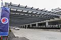
Front area of the Bicol International Airport Terminal Buildling
-

A PNR train in Ligao railway station


Famous People from Albay
- Crispin Beltran – A Filipino labor leader and former member of Congress.
- Barbie Imperial – An actress, model, and former reality TV show contestant.
- Francis Tolentino – A former chairman of the Metropolitan Manila Development Authority.
- Elizabeth Oropesa – A well-known actress.
- Simeon Ola – A famous revolutionary general.
- Ramon Paje – The 19th Secretary of Environment and Natural Resources.
- Ramon Obusan – A National Artist of the Philippines for Dance.
- Susan Enriquez – A journalist and TV host.
- Salvacion Lim Higgins – A National Artist of the Philippines for Fashion Design.
- Bogs Adornado – A three-time PBA Most Valuable Player in basketball.
- Merlinda Bobis – A contemporary Philippine-Australian writer and academic.
- Irene Cortes – A former Associate Justice of the Supreme Court of the Philippines. She was the first female Dean of the UP College of Law.
- Janelle Quintana – An actress.
- Valerie Weigmann – A TV host, actress, and Miss World Philippines 2014.
- Athena Imperial – A news reporter and Miss Philippines Earth 2011.
- Miguel White – A track and field athlete who won a bronze medal at the 1936 Summer Olympics.
- Jun Lozada – An electronics engineer and former CEO of the Philippine Forest Corporation.
- David Nepomuceno – The first Filipino to compete in the Olympics in 1924.
- Catriona Gray – The winner of Miss Universe 2018.
- Jonalyn Viray – A singer-songwriter.
- Pedro Sabido – A former Senator and Ambassador.
- Joey Salceda – A current Representative for Albay and former Provincial Governor.
- Reno Lim – A former Representative for Albay.
- Dianne Necio – A beauty pageant titleholder.
- Rodolfo Salalima – The first Secretary of the Department of Information and Communications Technology.
- Henry Omaga-Diaz – A journalist.
- Thomas Franco Rodriguez – A member of the Pinoy pop boy band Alamat.
- Juan Miguel "Migz" Zubiri – A senator and former Senate President. His family roots are from Libon, Albay.
See also
 In Spanish: Albáy para niños
- Biosphere reserves of the Philippines
