
Enewetak Atoll facts for kids

Landsat 8 satellite image of Enewetak Atoll. The crater formed by the Ivy Mike nuclear test can be seen near the north cape of the atoll, with the smaller Castle Nectar crater adjoining it.
|
|

Enewetak
Location in Marshall Islands
|
|
| Geography | |
|---|---|
| Location | North Pacific |
| Coordinates | 11°30′N 162°20′E / 11.500°N 162.333°E |
| Archipelago | Ralik |
| Total islands | 40 |
| Area | 5.85 km2 (2.26 sq mi) |
| Highest elevation | 5 m (16 ft) |
| Administration | |
| Demographics | |
| Population | 296 (2021) |
| Ethnic groups | Marshallese |


Enewetak Atoll is a large group of 40 islands in the Pacific Ocean. It is home to 296 people (as of 2021) and is part of the Ralik Chain of the Marshall Islands. The total land area is small, less than 5.85 square kilometers (2.26 sq mi), and the islands are very low, only about 5 meters (16 ft) above sea level. Enewetak surrounds a deep central lagoon that is 80 kilometers (50 mi) around. It is located about 305 kilometers (190 mi) west of Bikini Atoll.
Enewetak was controlled by Japan from 1914 until the United States took it over in February 1944 during World War II. After the war, it became a site for nuclear testing during the Cold War. From 1977 to 1980, a concrete dome called the Runit Dome was built on Runit Island to store radioactive soil and debris. This dome is now getting old, and there are concerns it could be damaged by strong storms.
Contents
About the Name
The U.S. government used to call the atoll "Eniwetok." But in 1974, they officially changed the spelling to "Enewetak." This change was made to better match how the local Marshallese people say the name.
Land and Sea
Enewetak Atoll sits on top of a very old seamount, which is like an underwater mountain. This seamount formed a long, long time ago, during the late Cretaceous period. It is now about 1,400 meters (4,600 ft) below the ocean surface. The seamount is made of basalt rock. Its deep position is due to the whole area slowly sinking over time, not because of erosion.
The islands of Enewetak are very flat, with an average height of only about 3 meters (10 ft) above sea level.
History of Enewetak
People have lived on Enewetak Atoll for a very long time, since about 1,000 B.C. The first people to settle here were islanders from the Austronesian group.
The first European explorer to reach Enewetak was Álvaro de Saavedra Cerón from Spain, who arrived on October 10, 1529. He named the islands "Los Jardines," meaning "The Gardens." Later, in 1794, British sailors called them "Brown's Range," which is why the Japanese later called it "Brown Atoll." Many ships visited the islands before Germany took control of the Marshall Islands in 1885.
World Wars
During World War I in 1914, the Imperial Japanese Navy took control of Enewetak, along with the rest of the Marshall Islands. In 1920, the League of Nations officially gave Japan permission to manage the islands. The Japanese mostly let the local leaders run things until World War II began.
In November 1942, the Japanese built an airfield on Engebi Island. They used it mainly for planes to refuel. In February 1944, during the Battle of Eniwetok, American forces captured Enewetak in a five-day operation. Most of the fighting happened on Engebi Islet, where the main Japanese base was. There was also fighting on Enewetak's main islet and on Parry Island, which had a Japanese seaplane base.
After the Americans captured it, Enewetak became a very important US Naval Advance Base. Many ships used its safe harbor. American Navy Seabees (construction battalions) arrived in February 1944 to build Stickell Field, a large airfield with two runways.
Nuclear Testing
After World War II, Enewetak was controlled by the United States as part of the Trust Territory of the Pacific Islands. This lasted until the Marshall Islands became independent in 1986. During this time, the United States moved the local residents off the islands many times, often without their full agreement. The atoll was used for nuclear testing as part of the Pacific Proving Grounds.
Before the tests began, the U.S. moved the bodies of American soldiers who died in the Battle of Enewetak back to the United States. From 1948 to 1958, 43 nuclear tests were carried out at Enewetak.
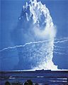
The first hydrogen bomb test, called Ivy Mike, happened in late 1952. This huge explosion completely destroyed the islet of Elugelab. During this test, special B-17 Flying Fortress planes were flown through the radioactive fallout clouds to collect samples.

Cleaning Up Radiation
From 1972 to 1973, a study was done to check the radiation levels on Enewetak. In 1977, the United States military started a big cleanup effort. Over three years, they spent about US$100 million. They mixed more than 80,000 cubic meters (100,000 cu yd) of contaminated soil and debris from the islands with Portland cement. This mixture was then buried in a large crater on Runit Island. This crater was made by the "Cactus" nuclear test in 1958.
A large concrete dome, made of 358 thick concrete panels, was built over the buried material. The total cost of this cleanup project was US$239 million. In 1980, the U.S. government said that the southern and western islands of the atoll were safe for people to live on again, and the residents of Enewetak returned that same year.
In 2000, more money was given for extra cleanup of radioactivity on Enewetak. Instead of removing all the topsoil, which would have been very expensive, many contaminated areas were treated with potassium. Soil that could not be cleaned well enough for people to use was removed and used to build a causeway connecting the two main islands, Enewetak and Parry.
Experts believe that most of the atoll will be safe for people to live on by 2026–2027, as the radiation slowly decreases and cleanup efforts continue. However, some reports in 2017 said that rising sea levels are causing water to leak into the Runit Dome, which could release radioactive material.
Relations with the U.S.
An agreement in 1983, called the Compact of Free Association, set up a way for the people of the Marshall Islands to claim money from the U.S. government for harm caused by nuclear testing. A fund of US$150 million was created to help with these claims.
A special court, called the Marshall Islands Nuclear Claims Tribunal, was set up to decide how much money people should receive. By 2000, the tribunal awarded the people of Enewetak US$107.8 million for environmental cleanup, US$244 million for economic losses (because they couldn't use their land), and US$34 million for hardship and suffering. However, due to financial problems, the fund has had trouble paying out all the money awarded.
Education
The Marshall Islands Public School System runs Enewetak Elementary School for younger students. Older students attend Marshall Islands High School on Majuro.
Enewetak Airfield
After the Battle of Eniwetok, American Seabees began building a large airfield on Eniwetok. They cleared the island and built a 2,100-meter (6,800 ft) long runway with taxiways and other buildings. The first plane landed there on March 11, 1944. By April 5, the airfield was being used for bombing missions. This base was later named Stickell Field.
The airstrip is no longer used today and is partly covered by sand.
Parry Island Seaplane Base
The Imperial Japanese Navy had a seaplane base on Parry Island. After American forces captured it on February 22, 1944, the Seabees expanded the base. They built a parking area and repair shops for aircraft. They also set up facilities to repair boats.
Nuclear Tests at Enewetak
Many nuclear tests were carried out at Enewetak. Here is a summary of the main test series:
| Series | Start Date | End Date | Count | Yield Range | Total Yield |
|---|---|---|---|---|---|
| Sandstone | 14 April 1948 | 14 May 1948 | 3 | 18 - 49 kilotons | 104 kilotons |
| Greenhouse | 7 April 1951 | 4 May 1951 | 4 | 45.5-225 kilotons | 396.5 kilotons |
| Ivy | 31 October 1952 | 15 November 1952 | 2 | 500 kilotons - 10.4 megatons | 10.9 megatons |
| Castle | 13 May 1954 | 13 May 1954 | 1 | 110 kilotons - 15 megatons | 48 megatons |
| Redwing | 4 May 1956 | 21 July 1956 | 11 | 190 tons - 1.9 megatons | ~2.61 megatons |
| Hardtack I | 5 April 1958 | 18 August 1958 | 22 | Zero - 8.9 megatons | 16.1 megatons |
| Total (on Enewetak) | 43 | Approx 31.8 megatons (almost 6% of total test yield worldwide) |
Images for kids
-
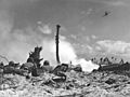
Battle of Eniwetok
-
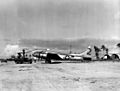
B-17 drone at Enewetak Airfield in 1948 for Operation Sandstone
-
Operation Sandstone
-
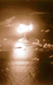
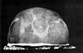
Ivy Mike test, October 31, 1952
-
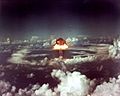
Operation Greenhouse test
-
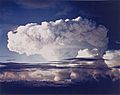
Ivy King test, November 1952
-
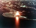
Test shot Seminole of Operation Redwing, conducted on the coast of the island of Bogon
-
Red-wing Seminole test
-
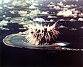
Hardtack Umbrella test


.jpg)


See also
 In Spanish: Enewetak para niños
