List of extreme points of the United States facts for kids
There are a number of different interpretations for "easternmost" and "westernmost"; see below for full treatment.
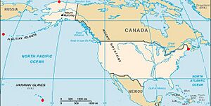
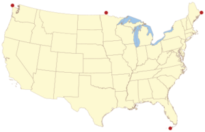
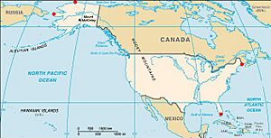
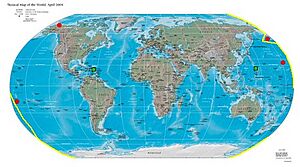
The United States is a huge country with many different places! This article lists the points that are the farthest north, south, east, or west. It also includes the highest and lowest spots, and other interesting geographic facts.
Contents
- Farthest North: Northernmost Points in the USA
- Farthest South: Southernmost Points in the USA
- Farthest East: Easternmost Points in the USA
- Farthest West: Westernmost Points in the USA
- Highest Points in the USA
- Lowest Points in the USA
- Other Interesting Geographic Points
- Islands of the USA
- Lakes of the USA
- Rivers of the USA
- Extreme Distances in the USA
- See also
Farthest North: Northernmost Points in the USA
- Northernmost point in the United States: Point Barrow, Alaska 71°23′20″N 156°28′45″W / 71.38889°N 156.47917°W. This is the very top tip of the country!
- Northernmost town in the United States: Utqiaġvik, Alaska 71°17′44″N 156°45′59″W / 71.29556°N 156.76639°W. About 5,000 people live here.
- Northernmost point in the 48 connected states: Northwest Angle Inlet in Lake of the Woods, Minnesota 49°23′04.1″N 95°9′12.2″W / 49.384472°N 95.153389°W. This spot is a small piece of land that sticks out into Canada.
- Northernmost capital city in the United States: Juneau, Alaska 58°17′57″N 134°25′13″W / 58.299104°N 134.420240°W.
- Northernmost capital city in the 48 connected states: Olympia, Washington 47°2′16″N 122°54′3″W / 47.03778°N 122.90083°W.
- Northernmost major city (over 1 million people) in the United States: Chicago, Illinois 41°53′1.9″N 87°37′53.87″W / 41.883861°N 87.6316306°W.
- Northernmost state by geographic center: Alaska. For the 48 connected states, it's North Dakota.
Farthest South: Southernmost Points in the USA
- Southernmost point in the United States: Rose Atoll, American Samoa 14°34′11″S 168°9′10″W / 14.56972°S 168.15278°W. This tiny island is far out in the Pacific Ocean.
- Southernmost town in the United States: Futiga, American Samoa 14°22′23″S 170°45′35″W / 14.372987°S 170.759741°W.
- Southernmost capital city in the United States: Pago Pago, American Samoa 14°16′26″S 170°42′05″W / 14.273821°S 170.701265°W.
- Southernmost point in the 50 states: Ka Lae, Hawaii 18°54′39″N 155°40′52″W / 18.91083°N 155.68111°W. This is also known as South Point.
- Southernmost town in the 50 states: Nā'ālehu, Hawaii 19°3′57″N 155°35′15″W / 19.06583°N 155.58750°W.
- Southernmost capital city in the 50 states: City and County of Honolulu, Hawaii 21°18′19″N 157°51′25″W / 21.30528°N 157.85694°W.
- Southernmost point in the 48 connected states (always above water): Ballast Key, Florida 24°31′15″N 81°57′49″W / 24.52083°N 81.96361°W.
- Southernmost point on the U.S. mainland: Cape Sable, Florida 25°7′6″N 81°5′11″W / 25.11833°N 81.08639°W.
- Southernmost major city (over 1 million people) in the United States: San Antonio, Texas 29°28′21″N 98°31′30″W / 29.4724°N 98.5251°W.
- Southernmost capital city in the 48 connected states: Austin, Texas 30°16′2″N 97°44′35″W / 30.26722°N 97.74306°W.
- Southernmost state by geographic center: Hawaii. For the 48 connected states, it's Florida.
Farthest East: Easternmost Points in the USA
- Easternmost point in the United States (by direction of travel): Point Udall, St. Croix, U.S. Virgin Islands 17°45′19″N 64°33′54″W / 17.75528°N 64.56500°W. This is where the sun rises first in the U.S.
- Easternmost town in the United States (by direction of travel): Christiansted, U.S. Virgin Islands 17°44′54″N 64°43′00″W / 17.7482°N 64.7168°W.
- Easternmost capital city in the United States (by direction of travel): Charlotte Amalie, U.S. Virgin Islands 18°20′26″N 64°55′52″W / 18.340688°N 64.931065°W.
- Easternmost point in the 50 states (by direction of travel): Sail Rock, Lubec, Maine 44°48′45.2″N 66°56′49.3″W / 44.812556°N 66.947028°W.
- Easternmost point on the U.S. mainland: West Quoddy Head, Maine 44°48′55.4″N 66°56′59.2″W / 44.815389°N 66.949778°W.
- Easternmost U.S. state capital: Augusta, Maine 44°18′25″N 69°46′55″W / 44.307°N 69.782°W.
- Easternmost major city (over 1 million people) in the United States: New York City, New York 40°39′49″N 73°56′19″W / 40.6635°N 73.9387°W.
- Easternmost point in all U.S. territory (by longitude): Pochnoi Point, Semisopochnoi Island, Alaska 51°57′42″N 179°46′23″E / 51.96167°N 179.77306°E. This point is actually in the Eastern Hemisphere, just barely!
- Easternmost capital city in the United States (by longitude): Saipan, Northern Mariana Islands 15°11′N 145°45′E / 15.183°N 145.750°E.
- Easternmost state by geographic center: Maine.
Farthest West: Westernmost Points in the USA
- Westernmost point and town in the United States (by direction of travel): Point Udall, Santa Rita, Guam (13°26′51″N 144°37′5.5″E / 13.44750°N 144.618194°E). This is where the sun sets last in the U.S.
- Westernmost capital city in the United States (by direction of travel): Hagåtña, Guam 13°28′38″N 144°44′50″E / 13.477264°N 144.747249°E.
- Westernmost point in the 50 states (by direction of travel): Peaked Island, offshore from Cape Wrangell, Attu Island, Alaska 52°55′14″N 172°26′16″E / 52.92056°N 172.43778°E. This island is so far west, it's almost in Russia!
- Westernmost point in all U.S. territories (by longitude): Amatignak Island, Alaska 51°16′7″N 179°8′55″W / 51.26861°N 179.14861°W.
- Westernmost incorporated city in the 50 states: Adak, Alaska 51°49′21″N 176°42′53″W / 51.8224°N 176.7147°W.
- Westernmost capital city in the United States (by longitude): Pago Pago, American Samoa 14°16′46″S 170°42′2″W / 14.27944°S 170.70056°W.
- Westernmost point on the North American continent: Cape Prince of Wales, Alaska 65°38′32″N 168°7′8″W / 65.64222°N 168.11889°W.
- Westernmost U.S. state capital: Honolulu, Hawaii 21°18′25″N 157°51′30″W / 21.30694°N 157.85833°W.
- Westernmost point in the 48 connected states (always above water): Bodelteh Islands, offshore from Cape Alava, Washington 48°10′42.7″N 124°46′18.1″W / 48.178528°N 124.771694°W.
- Westernmost point on the U.S. mainland (connected states): Cape Alava, Washington 48°9′51″N 124°43′59″W / 48.16417°N 124.73306°W.
- Westernmost incorporated place in the 48 connected states: Port Orford, Oregon 42°45′15″N 124°30′45″W / 42.754065°N 124.512605°W.
- Westernmost capital city in the 48 connected states: Salem, Oregon 44°56′21″N 123°2′22″W / 44.93917°N 123.03944°W.
- Westernmost major city (over 500,000 people) in the United States: Portland, Oregon 45°35.5′N 122°50.2′W / 45.5917°N 122.8367°W.
- Westernmost state by geographic center: Hawaii. For the 48 connected states, it's Oregon.
- Closest town to Russia: Diomede, Alaska, Little Diomede Island 65°45.5′N 168°57.2′W / 65.7583°N 168.9533°W.
Highest Points in the USA
- Highest summit in the United States and North America: Denali, Alaska 63°4′9″N 151°0′23″W / 63.06917°N 151.00639°W. It stands at 20,310 feet (6,190.5 meters) tall!
- Highest point in the 48 connected states: Mount Whitney, California 36°34′43″N 118°17′31″W / 36.57861°N 118.29194°W. This peak is 14,505 feet (4,421 meters) high.
- Highest island summit in all U.S. territory and the Pacific Ocean: Mauna Kea, Hawaiʻi 19°49′14″N 155°28′5″W / 19.82056°N 155.46806°W. It's 13,796 feet (4,205 meters) above sea level.
- Highest town in all U.S. territory: Alma, Colorado 39°17′2″N 106°3′46″W / 39.28389°N 106.06278°W. It's located at 10,355 feet (3,156 meters).
- Highest city in all U.S. territory: Leadville, Colorado 39°14′50″N 106°17′30″W / 39.24722°N 106.29167°W. It's 10,152 feet (3,094 meters) high.
- Highest capital city in all U.S. territory: Santa Fe, New Mexico 35°40′2″N 105°57′52″W / 35.66722°N 105.96444°W. It sits at 6,989 feet (2,130 meters).
- Highest major city (over 500,000 people) in all U.S. territory: Denver, Colorado 39°45′43″N 104°52′52″W / 39.76194°N 104.88111°W. Known as the "Mile High City," it's 5,280 feet (1,609 meters) high.
- Highest airfield in all U.S. territory and North America: Lake County Airport, Colorado 39°13′13″N 106°19′00″W / 39.22028°N 106.31667°W. It's at 9,927 feet (3,026 meters).
- Highest state based on average elevation: Colorado 39°00′N 105°30′W / 39.000°N 105.500°W. Its average elevation is 6,800 feet (2,073 meters).
- Highest point in the eastern United States: Mount Mitchell, North Carolina 35°45′53″N 82°15′54″W / 35.76472°N 82.26500°W. It reaches 6,684 feet (2,037 meters).
- Highest point on the Interstate Highway System: Eisenhower Tunnel, west of Denver, Colorado 39°40′43″N 105°55′12″W / 39.6785°N 105.92°W. It's 11,158 feet (3,401 meters) high.
Lowest Points in the USA
- Lowest surface point in all U.S. territory and North America: Badwater Basin, Death Valley, California, 36°14′23″N 116°50′5″W / 36.23972°N 116.83472°W. This spot is 279 feet (85 meters) below sea level!
- Lowest lake in all U.S. territory and North America: Salton Sea, California, 33°19′59″N 115°50′3″W / 33.33306°N 115.83417°W. It's 226 feet (69 meters) below sea level.
- Lowest airfield in all U.S. territory and the Western Hemisphere: Furnace Creek Airport, California 36°27′50″N 116°52′53″W / 36.46389°N 116.88139°W. It's 210 feet (64 meters) below sea level.
- Lowest settlement in all U.S. territory and the Western Hemisphere: Furnace Creek, California, 36°27′29″N 116°52′15″W / 36.45806°N 116.87083°W. It's 190 feet (58 meters) below sea level.
- Lowest city in all U.S. territory and the Western Hemisphere: Calipatria, California, 33°07′32″N 115°30′51″W / 33.12556°N 115.51417°W. It's 184 feet (56 meters) below sea level.
- Lowest surface point in the eastern United States: 9th Ward of New Orleans, Louisiana, 30°02′40″N 89°56′47″W / 30.04444°N 89.94639°W. It's 7 feet (2 meters) below sea level.
- Lowest city (over 250,000 people) in all U.S. territory and the Western Hemisphere: New Orleans, Louisiana, 29°58′N 90°03′W / 29.967°N 90.050°W. Its average elevation is 1.5 feet (0.46 meters) below sea level.
- Lowest state by average elevation: Delaware 39°0′17″N 75°32′46″W / 39.00472°N 75.54611°W. Its average elevation is 60 feet (18 meters).
- Lowest state high point: Britton Hill, Florida, 30°59′18″N 86°16′55″W / 30.98833°N 86.28194°W. The highest point in Florida is only 345 feet (105 meters) above sea level!
- Lowest freshwater point in all U.S. territory: Lake Superior bottom, Michigan, 46°54′31″N 86°35′52″W / 46.90861°N 86.59778°W. The bottom of the lake is 732 feet (223 meters) below sea level.
Other Interesting Geographic Points
- Geographic center of the 50 states: About 20 miles (32 km) north of Belle Fourche, South Dakota, 44°58′N 103°46′W / 44.967°N 103.767°W.
- Geographic center of the 48 connected states: About 4 miles (6 km) west of Lebanon, Kansas, 39°50′N 98°35′W / 39.833°N 98.583°W.
- Closest to the equator: Baker Island is at 0°11′41″N 176°28′46″W / 0.19472°N 176.47944°W. This tiny island is very close to the Earth's middle line.
- Most remote point in the 50 states: Ipnavik River, National Petroleum Reserve–Alaska, 68°45′N 156°41′W / 68.750°N 156.683°W. It's 120 miles (190 km) from the nearest town.
- Southwesternmost point of the connected United States: Border Field State Park, California.
- Northwesternmost point of the connected United States: Cape Flattery, Washington.
- Northeasternmost point of the connected United States: Van Buren, Maine, 47°14.140'N, 68°01.233'W.
Islands of the USA
- Most extensive island in all U.S. territory and tallest island in the Pacific Ocean: Island of Hawaiʻi, Hawaiʻi 19°49′15″N 155°28′5″W / 19.82083°N 155.46806°W. It covers 4,028 square miles (10,430 km2) and is 13,796 feet (4,205 meters) tall.
- Most extensive island of U.S. Caribbean territory: Island of Puerto Rico, Puerto Rico 18°15′N 66°30′W / 18.250°N 66.500°W. It's 3,515.1 square miles (9,104.1 km2).
- Most extensive island of the U.S. Atlantic coast: Long Island, New York 40°52′10″N 73°00′00″W / 40.86944°N 73.00000°W. It spans 1,401 square miles (3,629 km2).
- Longest barrier island on Earth: Padre Island, Texas 26°50′40″N 97°22′04″W / 26.84444°N 97.36778°W. It is 113 miles (182 km) long.
- Most extensive island in a lake in all U.S. territory: Isle Royale in Lake Superior, Michigan 48°0′N 88°55′W / 48.000°N 88.917°W. It's 206.73 square miles (535.4 km2).
- Most remote islands in the United States: These are within the U.S. Minor Outlying Islands, like Palmyra Atoll and Johnston Atoll.
Lakes of the USA
- Largest freshwater lake in the world by surface area: Lake Michigan-Huron 45°48′N 84°45′W / 45.800°N 84.750°W. It covers 45,300 square miles (117,000 km2), with 31,507 square miles (81,603 km2) in the United States.
- Second largest freshwater lake in the world by surface area: Lake Superior 47°42′N 87°30′W / 47.700°N 87.500°W. It's 31,700 square miles (82,100 km2), with 20,600 square miles (53,350 km2) in the U.S. It's also North America's largest lake by volume.
- Most extensive salt lake: Great Salt Lake, Utah, 41°10′N 112°35′W / 41.167°N 112.583°W. It covers 1,700 square miles (4,400 km2).
- Deepest lake in the U.S.: Crater Lake, Oregon, 42°57′N 122°5′W / 42.950°N 122.083°W. It's 1,943 feet (592 meters) deep.
- Highest elevation lake: Pacific Tarn, Colorado, 39°25′11″N 106°07′11″W / 39.41972°N 106.11972°W. It's at 13,420 feet (4,090 meters) high.
Rivers of the USA
- Most extensive river basin: Mississippi River 29°9′4″N 89°15′12″W / 29.15111°N 89.25333°W. Its basin covers 1,151,000 square miles (2,981,000 km2).
- Longest river system: Mississippi-Missouri-Jefferson Rivers 29°9′4″N 89°15′12″W / 29.15111°N 89.25333°W. This system is 3,902 miles (6,280 km) long.
- Longest main stem river: Missouri River 38°48′49″N 90°7′11″W / 38.81361°N 90.11972°W. It flows for 2,341 miles (3,767 km).
- Longest Pacific Ocean main stem river: Columbia River 46°14′39″N 124°3′29″W / 46.24417°N 124.05806°W. It is 1,243 miles (2,000 km) long.
Extreme Distances in the USA
- Greatest east–west distance in the 48 connected states: 2,800 miles (4,500 km).
- Greatest north–south distance in the 48 connected states: 1,650 miles (2,660 km).
- Greatest distance between any two points in U.S. territory: 9,514 miles (15,311 km), from Point Udall, Guam, to Point Udall, St. Croix, U.S. Virgin Islands.
- Greatest distance between any two points in the 50 states: 5,859 miles (9,429 km), from Kure Atoll, Hawaii, to Log Point, Elliott Key, Florida.
- Greatest distance between any two points in the connected 48 states: 2,901 miles (4,669 km), from North Farallon Island, California, to Sail Rock, east of West Quoddy Head, Maine.
- Greatest driving distance between any US territory in connected lower 48 states: 3,689 miles (5,937 km), from Fort Zachary Taylor, Key West, Florida, to Cape Flattery, Washington.
See also
 In Spanish: Anexo:Puntos extremos de los Estados Unidos para niños
- Borders of the United States
- Geography of the United States
- Extreme points of the Earth
- List of extreme points of U.S. states and territories
Black History Month on Kiddle
Distinguished African-American Artists:
 | Sharif Bey |
 | Hale Woodruff |
 | Richmond Barthé |
 | Purvis Young |

All content from Kiddle encyclopedia articles (including the article images and facts) can be freely used under Attribution-ShareAlike license, unless stated otherwise. Cite this article:
List of extreme points of the United States Facts for Kids. Kiddle Encyclopedia.


