
Semisopochnoi Island facts for kids

Eastern cone of Mount Cerberus in the Semisopochnoi Caldera.
|
|

|
|

Semisopochnoi
Location in Alaska
|
|
| Geography | |
|---|---|
| Location | Bering Sea |
| Coordinates | 51°57′05″N 179°36′03″E / 51.95139°N 179.60083°E |
| Archipelago | Rat Islands |
| Area | 221.59 km2 (85.56 sq mi) |
| Length | 18 km (11.2 mi) |
| Width | 20 km (12 mi) |
| Highest elevation | 1,221 m (4,006 ft) |
| Administration | |
|
|
|
| State | |
Semisopochnoi Island, also called Unyak Island, is a remote island in Alaska. It is part of the Rat Islands group, which is in the western Aleutian Islands. The island is not inhabited by people. It is a very important place for many types of sea birds to build their nests and raise their young.
Semisopochnoi Island was formed by volcanoes. It has several volcanoes, including Mount Cerberus. The island covers about 85.5 square miles (221.59 square kilometers). It is about 11 miles (18 km) long and 12 miles (20 km) wide.
Because of its location, the easternmost tip of Semisopochnoi is the easternmost land in the United States and North America by longitude. This means it is located in the Eastern Hemisphere. It sits just a short distance west of the 180th meridian, which is an imaginary line around the Earth.
Contents
Amazing Wildlife of Semisopochnoi Island
Semisopochnoi Island is a special place for animals, especially birds. It does not have any land mammals that are naturally from the island.
Protecting Ground-Nesting Birds
In the 1800s, Arctic foxes were brought to the island for fur farming. These foxes caused a lot of problems for the birds. They hunted many ground-nesting birds like the Aleutian cackling goose and rock ptarmigan. They also hunted seabirds that nest in burrows, such as storm-petrels, ancient murrelets, Cassin's auklets, and tufted puffins.
Because of the foxes, many of these bird populations disappeared from the island. This is called being extirpated, meaning they became locally extinct. In 1997, the foxes were removed from the island. Now, the island is slowly recovering, and the bird populations are starting to grow back. Luckily, the island has never had Norway rats, which can also be very harmful to bird nests.
Large Seabird Colonies
Semisopochnoi Island is home to one of the biggest colonies of least auklets and crested auklets in the Aleutian Islands. These small seabirds gather in huge numbers near a place called Sugarloaf Head. They breed together on the southern slopes of the Sugarloaf Peak volcano.
The island also has a large number of red-faced cormorants. In total, more than a million seabirds live on Semisopochnoi Island. Most of them are least auklets and crested auklets.
Geology and Volcanoes of Semisopochnoi

Semisopochnoi is the largest volcano that rises above the sea in the western Aleutian Islands. It is about 20 km wide at sea level. The island has a large bowl-shaped area called a caldera, which is 8 km wide. This caldera formed when a volcano collapsed after a huge eruption of dacitic pumice.
Understanding the Island's Peaks
The highest point on the island is Anvil Peak, which is 1,221 meters tall. It has two peaks and makes up a large part of the northern island. Inside the caldera is Mount Cerberus, a volcano with three peaks, standing 774 meters high. Each of its peaks has a crater at the top. The lava flows on the northern side of Mount Cerberus look newer than those on the southern side.
Other volcanoes that formed after the caldera include Sugarloaf Peak, which is 855 meters tall and has a symmetrical shape. It is located southeast of the caldera. Lakeshore Cone is a small cinder cone right next to Fenner Lake in the northeastern part of the caldera.
Recent Volcanic Activity
Most of the volcanic eruptions recorded in history have come from Mount Cerberus. However, some scientists believe that Sugarloaf and Lakeshore Cone might also have been active in the past.
The last known volcanic eruptions on Semisopochnoi happened in October 2018 and July 2019. An eruption was also reported in 1873. There might have been at least four other eruptions in the hundred years before that, but there isn't much information about them. These eruptions likely came from the sides of Mount Cerberus. The most recent lava flow appears to be less than a century old.
Images for kids
-
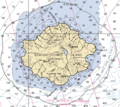
Semisopochnoi nautical chart

See also
 In Spanish: Isla Semisopochnoi para niños
