
Isle Royale facts for kids

Map of Isle Royale
|
|

Isle Royale
Location in Michigan
|
|
| Geography | |
|---|---|
| Location | Lake Superior |
| Coordinates | 48°0′N 88°55′W / 48.000°N 88.917°W |
| Area | 206.73 sq mi (535.4 km2) |
| Length | 45 mi (72 km) |
| Width | 9 mi (14 km) |
| Highest elevation | 1,394 ft (424.9 m) |
| Highest point | Mount Desor |
| Administration | |
|
United States
|
|
| State | Michigan |
| County | Keweenaw County |
| Townships | Eagle Harbor / Houghton |
| Demographics | |
| Population | 0 (2000) |
Isle Royale (ROY-əl) is a large island in Lake Superior. It is part of the state of Michigan in the United States. The island, along with 450 smaller islands and the surrounding waters, forms the Isle Royale National Park.
Isle Royale is about 45 miles (72 km) long and 9 miles (14 km) wide. It covers an area of 206.73 square miles (535.4 sq km). This makes it the fourth-largest lake island in the world. It is also the biggest natural island in Lake Superior. It is the second-largest island in the Great Lakes. Only Manitoulin Island is larger.
The island has no permanent residents. After it became a national park, some people were allowed to keep their homes. A few families still have special permission to live there.
Contents
Island Geography and Features
Isle Royale is located in Keweenaw County, Michigan. The highest point on the island is Mount Desor. It stands at 1,394 feet (425 meters) above sea level. This is about 800 feet (244 meters) above the lake.
The island is about 15 miles (24 km) from the Canadian shore. It is also close to Minnesota. However, it is 56 miles (90 km) from the Michigan mainland.
There are no roads on Isle Royale. You cannot use cars or bikes there. Only wheelchairs are allowed. Park staff use special vehicles to move supplies. The soil on the island is often thin. This helps trees like balsam fir and spruce to grow.
Lakes Inside the Island
Isle Royale has several lakes within its borders. Siskiwit Lake is the largest. It has cold, clear water with few nutrients. Siskiwit Lake also has its own islands, including Ryan Island.
Other lakes on Isle Royale include:
- Chicken Bone Lake
- Lake Desor
- Feldtmann Lake
- Intermediate Lake (Isle Royale)
- Lake Ritchie
- Sargent Lake
Island Climate
It is hard to find detailed weather information for Isle Royale. This is especially true for winter. However, we know that the island has cold winters and mild summers. Scientists use data from nearby areas to understand its climate.
Island Geology

The island has many ridges that run from southwest to northeast. The main ridge is called Greenstone Ridge. It is over 1,000 feet (305 meters) high in many places. You can find greenstone rocks near the lake.
The north sides of the ridges are usually steeper. Coastal areas were once underwater. They have many large rocks and boulders.
Island History
Native people from Minnesota and Ontario used Isle Royale for hunting. They would travel about 13 miles (21 km) by canoe to reach the island.
Ancient Copper Mining
Long ago, people mined a lot of copper on Isle Royale. They also mined copper on the nearby Keweenaw Peninsula. The land still shows signs of these old mines. There are pits and trenches up to 20 meters (66 feet) deep.
Scientists found wood in copper tools. They used Carbon-14 dating to learn that these tools are at least 6,500 years old. In 1670, a missionary wrote about an island called Menong. This was the native name for the island. It means "celebrated for its copper."
Isle Royale Becomes Part of the U.S.
The Treaty of Paris gave Isle Royale to the United States in 1783. But the British still controlled it for a while. The Ojibwa people also believed the island was theirs. The Ojibwas gave the island to the U.S. in the Treaty of La Pointe in 1842.
In the 1840s, a report about copper started a mining boom. New copper mines opened on the island. Miners found old tools and partially worked copper. These old sites helped them find new copper deposits.
However, the island was far away. The copper veins were also small. This made most 19th-century mines fail quickly. Logging and mining caused much of the island to lose its trees. When Isle Royale became a national park in 1940, these activities stopped. The forest then began to grow back.
Fishing and Shipwrecks
Isle Royale once had several fishing villages. There were also a few resorts. Today, no one lives there permanently. The fishing families were moved by the National Park Service in the 1940s. About 12 families still have special permission to use their cabins. They see Isle Royale as part of their family history. Some of their descendants still fish in the waters around the island.
The western part of the island has several shipwrecks. These are popular with scuba divers. One famous wreck is the SS America. The National Park Service has mapped 10 famous shipwrecks in the park.
The Survival of Angelique Mott
In 1845, an Ojibwe woman named Angelique and her husband, Charlie Mott, were left on Isle Royale. They were hired to find copper for a company. Angelique found a large piece of copper. She and Charlie were asked to guard it. A boat was supposed to pick them up in three months.
However, the boat never came. They were left stranded from July until the next spring. They had very little food. They lost their canoe in a storm. Their fishing net was also destroyed. By January 1846, Charlie became very weak from hunger. He eventually died.
Angelique had to leave his body in the cabin. She built a small shelter for herself. She survived by eating tree bark and berries. She even used her own hair to make snares to catch rabbits. In the spring of 1846, the boat finally returned. Angelique was brought back to her mother. She died in 1874.
Her story was written down in a book in 1907. It shows how tough it was to survive on the island. People usually only visited Isle Royale in the summer. Native Americans used it for copper and fish for thousands of years.
Isle Royale National Park
The island and its many smaller islands form Isle Royale National Park. It is one of the least visited national parks in the lower 48 states.
Fun Activities on the Island

Isle Royale offers many fun activities. You can go hiking, backpacking, fishing, boating, canoeing, and kayaking. It's also a great place to observe nature. Remember, no wheeled vehicles are allowed, except for wheelchairs.
Camping and Facilities
There are many campgrounds on the island. Many can only be reached by water. There are two main areas with services:
- Rock Harbor: This area has a resort, a marina, and basic supplies.
- Windigo: This is a smaller area on the western end of the island.
Both Rock Harbor and Windigo offer paid showers and food. A typical campground has shelters, tent sites, and picnic tables. There are also pit toilets. Campgrounds along the shore have boat docks. Many canoeists and kayakers stay at these sites. You should filter or boil all water before drinking it. This helps prevent sickness from parasites.


Hiking Trails
Isle Royale has about 170 miles (274 km) of hiking trails. You can take short day hikes or long trips. Some trails are very challenging with steep hills. The most popular trail is the 40-mile (64 km) Greenstone Ridge Trail. It runs along the island's main ridge. This trail leads to Mount Desor, the highest point on the island. It passes through forests, lakes, and swamps.
Island Ecology
Isle Royale has different habitats. The main one is a boreal forest, like in nearby Canada and Minnesota. Some high areas have exposed rock with few trees. These areas have blueberry bushes and grasses. There are also marshes created by beavers. The cold water of Lake Superior greatly affects the island's climate.
Wolves and Moose Study
Isle Royale is famous for a long-term study of predator-prey relationships. Scientists study the moose and eastern timber wolves on the island. This study began in 1958. The populations of these two animals go up and down together. When moose numbers increase, wolf numbers also increase. Eventually, wolves kill too many moose. Then, the wolf population goes down because they don't have enough food.
Historically, moose and wolves were not on Isle Royale. Before it became a national park, the largest mammals were Lynx and Boreal woodland caribou. These animals were on the island for 3,500 years. They disappeared due to human actions like hunting and logging. The last caribou was seen in 1925. Lynx have crossed from Canada sometimes, but they are not present now. Coyotes were also on the island but disappeared after wolves arrived in the 1950s. In 2018, four wolves were brought from Minnesota to help the population.
Other Island Animals
Other common mammals on Isle Royale include red foxes, beavers, and red squirrels. Some foxes are used to people. They might look for food scraps in campgrounds. Wolves are shy and avoid humans. You might also see mink near the shores and muskrats in beaver ponds. Several types of bats also live on the island.
Reptiles found here include the eastern garter snake, painted turtle, and northern redbelly snake. Six kinds of frogs and three kinds of salamanders also live on Isle Royale.
How to Get to Isle Royale

You can reach the island by private boat or seaplane. There are also three private ferry services and one National Park Service ferry.
Ferries usually run from May through September:
- The Ranger III is run by the National Park Service. It travels from Houghton, Michigan, to Rock Harbor twice a week.
- The Isle Royale Queen IV travels daily from Copper Harbor, Michigan, to Rock Harbor.
Island Settlements and Services
Images for kids
-
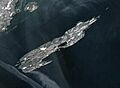
MODIS image of Isle Royale

See also
 In Spanish: Isla Royale para niños
