Houghton Township, Michigan facts for kids
Quick facts for kids
Houghton Township, Michigan
|
|
|---|---|

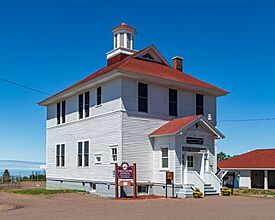
Houghton Township Community Center
|
|

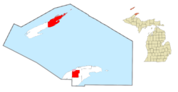
Location within Keweenaw County (red) and the administered CDP of Eagle River (pink)
|
|
| Country | United States |
| State | Michigan |
| County | Keweenaw |
| Established | 1861 |
| Area | |
| • Total | 517.42 sq mi (1,340.11 km2) |
| • Land | 120.72 sq mi (312.66 km2) |
| • Water | 396.70 sq mi (1,027.45 km2) |
| Elevation | 630 ft (192 m) |
| Population
(2020)
|
|
| • Total | 72 |
| • Density | 0.85/sq mi (0.33/km2) |
| Time zone | UTC-5 (Eastern (EST)) |
| • Summer (DST) | UTC-4 (EDT) |
| ZIP code(s) | |
| Area code(s) | 906 |
| FIPS code | 26-39380 |
| GNIS feature ID | 1626493 |
Houghton Township is a special kind of local government area called a civil township. It is located in Keweenaw County in the U.S. state of Michigan. In 2020, only 72 people lived there.
This township includes a part of the Keweenaw Peninsula mainland. It also has the county seat, Eagle River. A large, empty part of Isle Royale National Park is also within Houghton Township.
Exploring Houghton Township's Geography
Houghton Township covers a huge area. It has a total area of about 517.42 square miles (1340.11 square kilometers). Most of this area, about 396.70 square miles (1027.45 square kilometers), is water! Only about 120.72 square miles (312.66 square kilometers) is land.
Because it has so much water, Houghton Township is one of the largest local areas in Michigan by total size. It has more water boundaries than any other similar area in the state.
Main Roads in Houghton Township
Two important roads help people travel through Houghton Township:
- U.S. Route 41 (US 41) goes from west to east through the middle of the township.
- Michigan Highway 26 (M-26) also runs with US 41 for a bit. Then, it turns north in a place called Phoenix.
Communities and Settlements
Houghton Township is home to several small communities. Each has its own story:
Central: A Mining Town's Past
Central is a small, unincorporated community. It grew up around the successful Central Mine. This mine started working in 1854. A post office opened here in 1871. The mine closed in 1894, and the post office closed ten years later.
Eagle Nest: Near Eagle River
Eagle Nest is another unincorporated community. It is located just southeast of Eagle River.
Eagle River: The County Seat
Eagle River is an unincorporated community. It is also a census-designated place, which means it's a special area for counting people. It sits right along Lake Superior. Eagle River is important because it is the main town, or county seat, for Keweenaw County.
Phoenix: A Road Junction
Phoenix is an unincorporated community. It is found where U.S. Route 41 and M-26 meet.
Rock Harbor Lodge: Isle Royale's Gateway
Rock Harbor Lodge is a community on Isle Royale. It is only open during certain seasons. This is the main place where visitors arrive to explore the national park. It is also the northernmost community in Michigan. However, no one lives there during the cold winter months.
Vaughsville: An Early Settlement
Vaughsville is an unincorporated community in the western part of the township. It is along US 41. Joel Vaugh first settled this area in 1849. He planned for it to be a village. But after he passed away in 1862, the settlement became much smaller.
Who Lives in Houghton Township?
2020 Population Count
In 2020, the census counted 72 people living in Houghton Township. These people lived in 41 households, and 27 of those were families. Most of the people, about 97.22%, were white. A small number, 2.78%, were from two or more races. No one identified as Hispanic or Latino in the 2020 census.
See also
 In Spanish: Municipio de Houghton para niños
 | John T. Biggers |
 | Thomas Blackshear |
 | Mark Bradford |
 | Beverly Buchanan |


