
Keweenaw County, Michigan facts for kids
Quick facts for kids
Keweenaw County
|
|
|---|---|

Keweenaw County Courthouse (built 1866) in Eagle River
|
|

Location within the U.S. state of Michigan
|
|
 Michigan's location within the U.S. |
|
| Country | |
| State | |
| Founded | March 11, 1861 |
| Named for | Keweenaw Bay |
| Seat | Eagle River |
| Largest settlement | Mohawk (CDP) Ahmeek (village) |
| Area | |
| • Total | 5,966 sq mi (15,450 km2) |
| • Land | 540 sq mi (1,400 km2) |
| • Water | 5,426 sq mi (14,050 km2) 91% |
| Population
(2020)
|
|
| • Total | 2,046 |
| • Density | 4.0/sq mi (1.5/km2) |
| Time zone | UTC−5 (Eastern) |
| • Summer (DST) | UTC−4 (EDT) |
| Congressional district | 1st |
Keweenaw County (pronounced KEE-wə-naw) is a county located in the western part of Michigan's Upper Peninsula. It is the northernmost county in the state.
According to the 2020 census, only 2,046 people live here. This makes it Michigan's county with the fewest people. Even though it has a small population, it is the largest county in Michigan by total area. This includes a lot of water from Lake Superior. The main town and county seat is Eagle River.
Keweenaw County is at the end of the Keweenaw Peninsula. It is part of the Houghton, Michigan micropolitan area. The county is home to two National Park Service sites: Isle Royale National Park and Keweenaw National Historical Park. This area is also known as Michigan's Copper Country. Copper mining was very important here from the 1840s to the 1960s.
Contents
History of Keweenaw County
Keweenaw County was officially created in 1861. The name "Keweenaw" comes from an Ojibwe word. It means "portage" or "a place where you carry boats over land." This makes sense because of nearby Portage Lake and Portage River. Together, these waterways form the Keweenaw Waterway.
Geography and Natural Features
Keweenaw County has two main land areas. These are Isle Royale and the northeastern part of the Keweenaw Peninsula. The county also includes a large area of Lake Superior waters. These waters reach the state borders with Ontario in Canada and Minnesota.
This makes Keweenaw County Michigan's largest county by total area. It covers about 5,966 square miles. However, only 540 square miles of this is land. A huge 5,426 square miles (91%) is water! Keweenaw County has the highest percentage of water area of any county in the United States.
The biggest lake completely within the county is Gratiot Lake. It covers 1,438 acres. This lake is located near the county's two highest peaks. These are Mt. Horace Greeley, which is 1,550 feet tall, and Mt. Gratiot, which is 1,490 feet tall. Other lakes include Lac La Belle, Lake Medora, and Lake Fanny Hooe.
You can only reach the mainland part of Keweenaw County by land through Houghton County.
Protected Areas and Parks
Keweenaw County is home to important natural and historical sites.
- Isle Royale National Park is a beautiful island park.
- Keweenaw National Historical Park (part) protects the history of copper mining.
Main Roads and Highways
- runs through the county. It goes from southwest to northeast. It passes through towns like Phoenix and Delaware. It ends near Copper Harbor.
- forms a loop from Phoenix. It then follows the Lake Superior shoreline. It meets US 41 in Copper Harbor.
Neighboring Areas
Keweenaw County is unique because it connects to the U.S. state of Minnesota. This connection is made by a ferry service. The ferry travels from Grand Portage to Windigo and Rock Harbor on Isle Royale.
By Land
- Houghton County, to the south
By Water
- Thunder Bay District, Ontario, Canada, to the north
- Alger County, to the east
- Marquette County, to the southeast
- Ontonagon County, to the southwest
- Cook County, Minnesota, to the northwest
Towns and Communities
Keweenaw County has several towns and smaller communities.

Village
Census-Designated Places
These are areas that are like towns but are not officially incorporated.
- Copper Harbor
- Fulton
- Eagle Harbor
- Eagle River (This is the county seat)
- Mohawk
Civil Townships
These are local government areas.
- Allouez Township
- Eagle Harbor Township
- Grant Township
- Houghton Township
- Sherman Township
Other Small Communities
- Allouez
- Bete Grise
- Betsy
- Bumbletown
- Central
- Copper Falls
- Delaware
- Eagle Nest
- Gay
- Hebards
- Lac La Belle
- Mandan
- Nepco Camp Number 7
- Ojibway
- Phoenix
- Rock Harbor Lodge
- Seneca
- Snowshoe
- Traverse
- Vaughnsville
- Windigo
- Wyoming
Ghost Towns
These are towns that used to exist but are now abandoned.
Population and People

The 2010 United States census showed that Keweenaw County had 2,156 people. This was a small decrease from the year 2000. By the 2020 census, the population was 2,046. This makes it Michigan's least populated county.
In 2010, most of the people (98.5%) were White. A small number were Black, Native American, or of two or more races. About 0.7% of the population was Hispanic or Latino. Many people had Finnish (28.8%), German (14.0%), or English (9.0%) backgrounds.
More recent estimates from 2022 show that most residents are still non-Hispanic white. The county's religious population is mostly Christian. The Evangelical Lutheran Church in America is the largest Christian group. The Roman Catholic Church is the second largest.
Images for kids
-
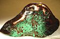
A polished piece of native copper from Keweenaw County. Copper mines here were very important in the late 1800s and early 1900s.
-
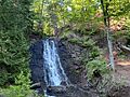
Haven Falls, located on Haven Creek near Lac La Belle.


See also
 In Spanish: Condado de Keweenaw para niños
