
Copper Harbor, Michigan facts for kids
Quick facts for kids
Copper Harbor, Michigan
|
|
|---|---|

Aerial view of the Copper Harbor community
|
|

Location within Keweenaw County
|
|

Copper Harbor, Michigan
Location in Michigan

Copper Harbor, Michigan
Location in the United States
|
|
| Country | United States |
| State | Michigan |
| County | Keweenaw |
| Township | Grant |
| Established | 1844 |
| Area | |
| • Total | 2.43 sq mi (6.28 km2) |
| • Land | 1.51 sq mi (3.92 km2) |
| • Water | 0.91 sq mi (2.37 km2) |
| Elevation | 605 ft (184 m) |
| Population
(2020)
|
|
| • Total | 136 |
| • Density | 89.89/sq mi (34.71/km2) |
| Time zone | UTC−5 (Eastern (EST)) |
| • Summer (DST) | UTC−4 (EDT) |
| ZIP code(s) |
49918
49950 (Mohawk) |
| Area code(s) | 906 |
| FIPS code | 26-18100 |
| GNIS feature ID | 623809 |
Copper Harbor is a small community in Keweenaw County, Michigan. It's known as an unincorporated community and a census-designated place (CDP). This means it's a recognized area with its own population count, but it's not an official city or town. In 2020, 136 people lived here.
Copper Harbor is located at the very top of the Keweenaw Peninsula. It's the northernmost place in Michigan where people live all year round. Because of its beautiful nature and places like Fort Wilkins Historic State Park, Copper Harbor is a popular spot for tourists any time of the year.
Contents
What's in a Name? The Story of Copper Harbor
The name Copper Harbor tells you about its past. The community's harbor was once a busy port. In the mid-1800s, ships used it to transport copper that was dug up from mines nearby.
A Look Back: Copper Harbor's History

Before European settlers arrived, the Keweenaw Peninsula was home to the Ojibwe people. In 1836, a big agreement called the Treaty of Washington was signed. This treaty officially gave the Upper Peninsula from the Native American Chippewa to the United States.
In 1843, Captain Walter Cunningham came to the area. He was sent by the United States Department of War to set up the first office for mineral lands. This office, called the "Government House," was on Porter's Island. This small island is right across from where downtown Copper Harbor is today.
Mining for copper began in 1844. The Pittsburgh and Boston Copper Harbor Mining Company started digging near Haye's Point. Their mine was very modern for its time. In 1845, they found a lot of copper, making them very successful. These were some of the first mining operations in Michigan.
Later, other mines like the Central Mine and Cliff Mine also opened and did well. However, by 1870, most of the copper in the area had been dug out.
In 2010, Copper Harbor was officially listed as a census-designated place. This means it now has clear borders and its population is counted in the census.
Where is Copper Harbor?
Copper Harbor is a census-designated place with a total area of about 2.43 square miles (6.28 square kilometers). About 1.51 square miles (3.92 square kilometers) of this is land, and the rest is water.
The community sits at the very northern edge of the Keweenaw Peninsula. Copper Harbor has its own post office and ZIP Code (49918). Some nearby areas might use the Mohawk 49950 ZIP Code.
Outside the main community, you'll find thick forests and not many roads or buildings.
Copper Harbor is about 9 miles (14 km) from Mandan. It's 12 miles (19 km) north of Delaware and 16 miles (26 km) east of Eagle Harbor. The closest official village is Ahmeek, which is about 30 miles (48 km) to the southwest.
Weather in Copper Harbor
Copper Harbor has a humid continental climate. This means it has warm summers, but they are rarely very hot. This is because of the cooling effect of Lake Superior. Winters are cold and snowy, but they are a bit milder than other places at the same northern latitude. This is also due to the lake's influence.
Even though winter temperatures are similar to a city like Minneapolis, spring arrives later in Copper Harbor. This is because the lake keeps the area cool for longer. For example, the coldest temperature ever recorded in Copper Harbor was in March!
| Climate data for Copper Harbor, Michigan (Fort Wilkins Historic State Park), 1991–2020 normals, extremes 1972–2020 | |||||||||||||
|---|---|---|---|---|---|---|---|---|---|---|---|---|---|
| Month | Jan | Feb | Mar | Apr | May | Jun | Jul | Aug | Sep | Oct | Nov | Dec | Year |
| Record high °F (°C) | 46 (8) |
55 (13) |
75 (24) |
80 (27) |
89 (32) |
94 (34) |
99 (37) |
94 (34) |
95 (35) |
83 (28) |
71 (22) |
56 (13) |
99 (37) |
| Mean maximum °F (°C) | 38.8 (3.8) |
43.2 (6.2) |
53.5 (11.9) |
65.1 (18.4) |
78.6 (25.9) |
84.1 (28.9) |
86.9 (30.5) |
86.1 (30.1) |
82.0 (27.8) |
72.6 (22.6) |
55.4 (13.0) |
43.7 (6.5) |
89.1 (31.7) |
| Mean daily maximum °F (°C) | 22.8 (−5.1) |
24.6 (−4.1) |
33.8 (1.0) |
44.0 (6.7) |
57.4 (14.1) |
67.1 (19.5) |
73.2 (22.9) |
73.4 (23.0) |
66.0 (18.9) |
51.9 (11.1) |
39.0 (3.9) |
28.5 (−1.9) |
48.5 (9.2) |
| Daily mean °F (°C) | 17.0 (−8.3) |
17.4 (−8.1) |
25.6 (−3.6) |
36.0 (2.2) |
48.0 (8.9) |
56.7 (13.7) |
63.8 (17.7) |
64.9 (18.3) |
58.1 (14.5) |
45.4 (7.4) |
33.4 (0.8) |
23.4 (−4.8) |
40.8 (4.9) |
| Mean daily minimum °F (°C) | 11.2 (−11.6) |
10.1 (−12.2) |
17.4 (−8.1) |
28.1 (−2.2) |
38.5 (3.6) |
46.4 (8.0) |
54.4 (12.4) |
56.3 (13.5) |
50.3 (10.2) |
38.9 (3.8) |
27.8 (−2.3) |
18.2 (−7.7) |
33.1 (0.6) |
| Mean minimum °F (°C) | −2.9 (−19.4) |
−6.0 (−21.1) |
−3.0 (−19.4) |
15.3 (−9.3) |
28.8 (−1.8) |
37.4 (3.0) |
45.5 (7.5) |
46.6 (8.1) |
38.8 (3.8) |
28.8 (−1.8) |
15.0 (−9.4) |
3.2 (−16.0) |
−6.7 (−21.5) |
| Record low °F (°C) | −18 (−28) |
−22 (−30) |
−23 (−31) |
−2 (−19) |
16 (−9) |
31 (−1) |
42 (6) |
32 (0) |
30 (−1) |
21 (−6) |
−5 (−21) |
−11 (−24) |
−23 (−31) |
| Average precipitation inches (mm) | 2.24 (57) |
1.89 (48) |
1.70 (43) |
2.68 (68) |
3.55 (90) |
3.07 (78) |
3.02 (77) |
2.63 (67) |
3.71 (94) |
3.72 (94) |
2.60 (66) |
2.33 (59) |
33.14 (842) |
| Source: NOAA | |||||||||||||
Fun Places to Visit in Copper Harbor
- Hunter's Point is a flat piece of land that reaches into Lake Superior. It's named after an early settler. Today, it's a park with many different plants and animals. It's also a popular spot for birds that are migrating.
- The northern end of U.S. Highway 41 is just outside Copper Harbor. This highway is super long, running about 1,990 miles (3,200 km) all the way to Miami, Florida!
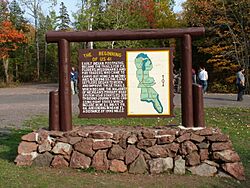
- Fort Wilkins Historic State Park is just north of downtown Copper Harbor. This old United States Army base was built in 1844. It was meant to protect the important port of Copper Harbor during the early copper mining boom. People soon realized the real challenges were the harsh winters and being isolated.

- The Copper Harbor Schoolhouse is one of Michigan's oldest one-room schools. In 1999, nine students attended classes here. The school's motto is "Searching For Knowledge," and its mascot is the Copper Harbor Prospectors.
- Copper Harbor hosts a fantastic Fourth of July fireworks show. It's a big event for the whole Keweenaw Peninsula.
- Lake Fanny Hooe is next to Fort Wilkins. It's named after the younger sister-in-law of a mining captain. This lake is about one mile east of Copper Harbor and runs alongside highway M-26. It's two miles long and a quarter mile wide.
- The historic Copper Harbor Lighthouse stands at the entrance to the harbor. It was rebuilt in 1866, replacing an older light from 1849. You can only reach it by taking a short boat ride from the Copper Harbor Marina. This lighthouse stopped working in 1933. It is one of the oldest lighthouses on Lake Superior. Inside, you can see how lighthouse keepers used to live. The museum also shares stories about shipwrecks in the area.
- The historic Copper Harbor Cemetery has gravestones of some of the first settlers in the Copper Country. The earliest burial recorded was in 1853. Many tombstones are from before the year 1900.
- Brockway Mountain Drive is often called "the most beautiful road in Michigan." This 8.9-mile (14.3 km) road follows a ridge that is 735 feet (224 m) high. It connects Copper Harbor and Eagle Harbor. It's the highest paved road between the Rocky Mountains and the Allegheny Mountains. The road was built in the 1930s during the Great Depression. It offers amazing views of Lake Superior, the Keweenaw Peninsula, and even Isle Royale on a clear day. There's also a special spot called Brockway Mountain Lookout where you can see the community of Copper Harbor below.
- Besides the main 1849 Copper Harbor Lighthouse, there are also the Copper Harbor Front Range and Rear Range Lights. These were finished in 1869. They are important local landmarks and are often seen on souvenirs. Their job was to guide ships safely past dangerous reefs that the main lighthouse couldn't show.
Who Lives Here?
| Historical population | |||
|---|---|---|---|
| Census | Pop. | %± | |
| 2020 | 136 | — | |
| U.S. Decennial Census | |||
In 2020, the population of Copper Harbor was 136 people. In 2021, the average household income was about $54,583.
Gallery
-
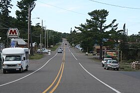
US 41 through Copper Harbor
-
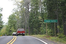
Signage along US 41
-
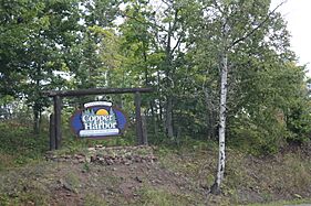
Copper Harbor welcome sign
-
Northern terminus of US 41, October 2006


Getting Around Copper Harbor
Highways
 US 41 runs through Copper Harbor. Its northernmost end is just east of the community.
 M-26 also ends in Copper Harbor, connecting with US 41 in the western part of the community.
Ferry Services
Copper Harbor has a ferry port. You can take a ferry from here to Isle Royale National Park. The Isle Royale Line, Inc. runs the Isle Royale Queen IV ferry from May to September. The ferry trip takes about 3.5 hours to travel 60 miles (97 km) across Lake Superior to Rock Harbor.
See also
 In Spanish: Copper Harbor (Míchigan) para niños
