Attu Island facts for kids
|
Native name:
Atan
|
|
|---|---|
Attu Island
|
|
 |
|
| Geography | |
| Coordinates | 52°54′09″N 172°54′34″E / 52.90250°N 172.90944°E |
| Archipelago | Near Islands group of the Aleutian Islands |
| Area | 344.7 sq mi (893 km2) |
| Length | 35 mi (56 km) |
| Width | 20 mi (30 km) |
| Highest elevation | 2,946 ft (897.9 m) |
| Highest point | Attu Mountain |
| Administration | |
|
United States
|
|
| State | Alaska |
| Census Area | Aleutians West Census Area |
| Demographics | |
| Population | 20 (2010–present) |
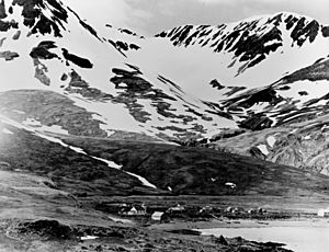
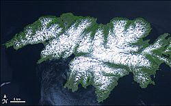
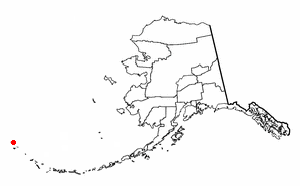
Attu (called Atan by the Aleut people) is an island in the Near Islands. These islands are part of the Aleutian Islands chain in Alaska. Attu is the westernmost point of the United States.
In 2010, the island became empty of people. This made it the largest uninhabited island that is part of the United States.
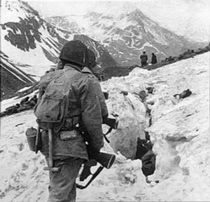
Attu was the location of the only World War II land battle fought in the United States. This battlefield is now a U.S. National Historic Landmark.
Attu Station, a former Coast Guard base, is one of the westernmost points of the U.S. It is in the Eastern Hemisphere, which means it's on the other side of the 180° longitude line from the main 48 states. This also makes it one of the easternmost points by that measure. However, the International Date Line passes to the west of Attu. This means Attu has the same calendar date as the rest of the U.S.
The nearest island to Attu in the Aleutian chain is the Russian Commander Islands. They are about 208 miles (335 km) away. Attu is far from the Alaskan mainland, about 1,100 miles (1,770 km) away. It is also about 1,500 miles (2,414 km) from Anchorage.
Attu Island is about 20 miles (32 km) wide and 35 miles (56 km) long. Its land area is 344.7 square miles (893 km²). This makes it the 23rd largest island in the United States. In 2010, 20 people lived there, all at the Attu Station. But they all left when the station closed later that year.
In 1982, there were a few trees on the island. American soldiers planted them near a chapel after the 1943 battle. These trees are no longer there.
Attu Island is the westernmost land east of the International Date Line. However, its time zone is UTC−10. This means some places further south, like Baker Island, have earlier clocks.
Contents
History of Attu Island
The name Attu comes from the Aleut people who lived there. An explorer named Aleksei Chirikov called it Saint Theodore in 1742. Attu was the first of the Aleutian Islands that Russian traders visited.
Early estimates by Russians said about 175 Aleuts lived on Attu. But old village sites suggest that 2,000 to 5,000 people might have lived there before Europeans arrived. Russians stayed on the island for years to hunt sea otters. They often had conflicts with the local Aleut people. After the first traders, ships often passed Attu by, heading further east.
World War II on Attu
|
Attu Battlefield and U.S. Army and Navy Airfields on Attu
|
|
| Lua error in Module:Location_map at line 420: attempt to index field 'wikibase' (a nil value). | |
| Built | 1942 |
|---|---|
| NRHP reference No. | 85002729 |
| Significant dates | |
| Added to NRHP | February 4, 1985 |
| Designated NHL | February 4, 1985 |
Before World War II, the Aleut people were the main residents of Attu. On June 7, 1942, Japanese soldiers landed on Attu Island. They faced no resistance. This happened one day after they landed on nearby Kiska Island.
The U.S. had already moved about 880 Aleuts from other Aleutian villages. These people were sent to camps in Alaska Panhandle. About 75 of them died from sickness there.
However, Attu Village had not been moved when the Japanese arrived. At that time, 45 native Aleuts lived on Attu. There were also two Americans: Charles Foster Jones, a radio technician, and his wife Etta, a schoolteacher. The village had several houses near Chichagof Harbor. The 42 Attu villagers who survived the Japanese invasion were taken to a prison camp in Japan. Sixteen of them died while they were prisoners.
General Kiichiro Higuchi, the Japanese Northern Army Commander, said the invasion of Kiska and Attu had three goals:
- To stop any attacks against Japan from the Aleutians.
- To create a barrier between the U.S. and Russia.
- To prepare air bases for future attacks.
In late 1942, the Japanese soldiers on Attu moved to Kiska. Attu was left empty for a short time. But on October 29, 1942, the Japanese returned to Attu. They set up a new base at Holtz Bay. About 500 troops were there at first. This number grew to about 2,300 by March 1943. No more soldiers arrived after that. This was because the U.S. Navy, led by Rear Admiral Charles McMorris, stopped Japanese supply ships. After a naval battle, the Japanese used only submarines to resupply their bases.
On May 11, 1943, American forces began their plan to take back Attu. It was very difficult because of bad weather and rough land. There were not enough landing boats, and equipment often broke down. Many soldiers got frostbite because supplies could not reach them. Japanese defenders did not fight at the landing sites. Instead, they dug in on high ground.
This led to very tough fighting. The U.S. had 3,929 casualties. This included 580 killed and 1,148 injured. Many also suffered from cold or sickness. The Japanese were defeated in Massacre Valley. About 2,035 Japanese soldiers died. The Americans then built "Navy Town" near Massacre Bay.
On May 29, the remaining Japanese forces launched a sudden attack near Massacre Bay. This was one of the largest such attacks in the Pacific War. The attack, led by Colonel Yamasaki, pushed deep into American lines. After fierce fighting, almost all the Japanese soldiers were killed. Only 28 were captured. U.S. teams counted 2,351 Japanese dead.
After this, other Japanese forces in the Aleutians realized they were in danger. They left Kiska three months later.
The USAAF built a larger airfield called Alexai Point Army Airfield. From there, on July 10, 1943, they launched an air attack on the Japanese-held Kurile Islands. This was the first air attack on Japan's home islands since the famous Doolittle Raid in 1942. More attacks followed.
Attu After the War
After the war, the Aleut survivors from the Japanese prison camp were sent to other islands or to mainland Alaska. There were not enough people left to rebuild their old village on Attu.
The U.S. government decided to build a LORAN station on Attu's southern tip. About twenty members of the United States Coast Guard worked there. The station was moved a few times, finally to Massacre Bay in 1960.
In 1985, the battlefield and military sites were named a National Historic Landmark.
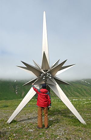
In 1987, the government of Japan placed a monument on Engineer Hill. This was where the last major fighting happened. The monument has a message in Japanese and English. It says: "In memory of all those who sacrificed their lives in the islands and seas of the North Pacific during World War II and in dedication to world peace."
In 2007 and 2008, the remains of Japanese soldiers were found on the island.
In 2010, the U.S. Coast Guard LORAN station on Attu closed for good. On August 27, 2010, the Coast Guard left. This made the island empty of people.
On June 7, 2012, a memorial was dedicated to Attu Village. It honored the residents who died in Japanese captivity and the survivors who could not return home.
Climate on Attu
The weather on Attu is typical for the Aleutian Islands. It is often cloudy, rainy, and foggy. Strong winds can happen sometimes. It usually rains five or six days a week. There are only about eight to ten clear days each year. Most of the time, even without rain, there is fog.
Attu gets about 39 to 49 inches (990 to 1,240 mm) of rain and other precipitation each year. The heaviest rains happen in the autumn and early winter. The climate is cool for its latitude, with summer temperatures averaging around 50-55°F (10-13°C).
| Climate data for Attu | |||||||||||||
|---|---|---|---|---|---|---|---|---|---|---|---|---|---|
| Month | Jan | Feb | Mar | Apr | May | Jun | Jul | Aug | Sep | Oct | Nov | Dec | Year |
| Record high °F (°C) | 49 (9) |
51 (11) |
49 (9) |
50 (10) |
59 (15) |
64 (18) |
72 (22) |
70 (21) |
68 (20) |
61 (16) |
54 (12) |
49 (9) |
72 (22) |
| Mean daily maximum °F (°C) | 34.4 (1.3) |
34 (1) |
35.3 (1.8) |
38.5 (3.6) |
42.7 (5.9) |
48.4 (9.1) |
52.6 (11.4) |
55.1 (12.8) |
52.2 (11.2) |
46.8 (8.2) |
40 (4) |
35.7 (2.1) |
43 (6) |
| Daily mean °F (°C) | 30.4 (−0.9) |
30.2 (−1.0) |
31.5 (−0.3) |
34.8 (1.6) |
38.9 (3.8) |
43.9 (6.6) |
48.4 (9.1) |
50.5 (10.3) |
47.8 (8.8) |
42.1 (5.6) |
35.5 (1.9) |
31.9 (−0.1) |
38.8 (3.8) |
| Mean daily minimum °F (°C) | 26.3 (−3.2) |
26.4 (−3.1) |
27.6 (−2.4) |
31 (−1) |
35.1 (1.7) |
39.4 (4.1) |
44.2 (6.8) |
45.8 (7.7) |
43.3 (6.3) |
37.4 (3.0) |
31 (−1) |
28.1 (−2.2) |
34.6 (1.4) |
| Record low °F (°C) | 5 (−15) |
7 (−14) |
5 (−15) |
10 (−12) |
15 (−9) |
19 (−7) |
24 (−4) |
28 (−2) |
20 (−7) |
21 (−6) |
15 (−9) |
2 (−17) |
2 (−17) |
| Average precipitation inches (mm) | 3.81 (97) |
3.61 (92) |
3.27 (83) |
3.79 (96) |
2.86 (73) |
2.94 (75) |
4.23 (107) |
6.02 (153) |
6.32 (161) |
6.63 (168) |
4.55 (116) |
4.61 (117) |
52.64 (1,337) |
| Average snowfall inches (cm) | 16.2 (41) |
16.9 (43) |
15 (38) |
6.5 (17) |
1.1 (2.8) |
0 (0) |
0 (0) |
0 (0) |
0 (0) |
0.6 (1.5) |
7.1 (18) |
13 (33) |
76.3 (194) |
| Average precipitation days | 19 | 17 | 18 | 16 | 13 | 11 | 13 | 15 | 17 | 19 | 20 | 19 | 197 |
Birdwatching on Attu
Attu was a very important place for competitive birdwatching. The goal in birdwatching is to see or hear as many bird species as possible. Because Attu is so far away from other parts of North America, many bird species found there are not seen anywhere else on the continent. Some birdwatchers called the island "the Holy Grail of North American birding."
After the U.S. Coast Guard station closed in 2010, it became much harder for birdwatchers to visit the island. This made it very difficult to break birdwatching records that included birds seen on Attu.
Attu in Popular Culture
- Attu Island is featured in the 2006 PBS documentary film Red White Black & Blue. This film shows two American war veterans returning to the island 60 years after the 1943 Battle of Attu.
- Attu is a setting for part of the 2011 movie The Big Year. The movie stars Steve Martin, Jack Black, and Owen Wilson as birdwatchers who visit the island.
- In 2013, the Chinese web-documentary On The Road visited Attu Island. The crew searched the island for fuel for their sailboat.
Population Changes
| Historical population | |||
|---|---|---|---|
| Census | Pop. | %± | |
| 1880 | 107 | — | |
| 1890 | 101 | −5.6% | |
| 1930 | 29 | — | |
| 1940 | 44 | 51.7% | |
| 1980 | 29 | — | |
| 2000 | 20 | — | |
| 2010 | 21 | 5.0% | |
| 2017 (est.) | 0 | −100.0% | |
| U.S. Decennial Census | |||
Attu first appeared on the U.S. Census in 1880 as "Attoo." It was an Aleut village with 107 residents. The population changed over the years. In 1940, just before the Japanese invasion, 44 people lived there. After the war, it appeared on the census again in 1980 as a naval station. The last time it appeared was in 2010, with 21 residents. All residents left when the station closed later that year.
Education
Before World War II, the Bureau of Indian Affairs (BIA) ran the only school on Attu. It had one teacher. As of 2017, the uninhabited island is part of the Aleutian Region School District.
See also
 In Spanish: Isla Attu para niños
 | Calvin Brent |
 | Walter T. Bailey |
 | Martha Cassell Thompson |
 | Alberta Jeannette Cassell |


