
Near Islands facts for kids
|
Native name:
Sasignan tanangin
|
|
|---|---|

Near Islands
Location in Alaska
|
|
| Geography | |
| Location | Pacific Ocean |
| Coordinates | 52°48′02″N 173°07′54″E / 52.80056°N 173.13167°E |
| Total islands | 15 |
| Major islands | Attu, Agattu |
| Area | 441.618 sq mi (1,143.79 km2) |
| Length | 25 mi (40 km) |
| Administration | |
|
United States
|
|
| State | Alaska |
| Demographics | |
| Population | >47 (2000) |
| Ethnic groups | Aleut |

The Near Islands or Sasignan Islands are a group of American islands. They are part of the Aleutian Islands in southwestern Alaska. These islands are located between the Russian Commander Islands to the west and the Rat Islands to the east. The native Aleut people call them Sasignan tanangin.
Geography
The two biggest islands in the Near Islands group are Attu and Agattu. There are also some smaller rocks and islets between them. Other important islands nearby include the Semichi Islands to the northeast. Among these, Alaid, Nizki, and Shemya are well-known.
About 20 miles (32 km) east-southeast of Shemya, you can find small rocky areas called the Ingenstrem Rocks.
The total land area of all the Near Islands is about 1,143.785 square kilometers (441.618 square miles). In the year 2000, only 47 people lived on these islands. The only island that still has people living on it is Shemya. The U.S. Coast Guard station on Attu closed in 2010. After that, everyone living on Attu Island left.
History
Russian explorers gave these islands the name Near Islands in the 1700s. They called them this because they were the closest of the Aleutian Islands to Russia. The Commander Islands are even closer, but they are part of Russia.
During World War II, the Imperial Japanese Army took control of the Near Islands in 1942. This was the first time a foreign military had occupied American land since the War of 1812. American forces fought to take back the islands in 1943. This was part of a larger fight called the Aleutian Islands Campaign.
-
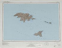
Topographic map sheet
-
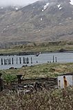
Attu Island in 2008
-
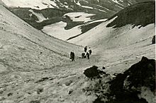
United States troops hauling supplies on Attu Island in May 1943.


See also
 In Spanish: Islas Near para niños
