
Shemya facts for kids

Shemya or Simiya (also called Samiyax̂ in the Aleut language) is a small island. It is located in the Aleutian Islands, a long chain of islands southwest of Alaska. Shemya is part of the Semichi Islands group, which is in the Near Islands chain.
The island is about 1,200 miles (1,931 km) southwest of Anchorage, Alaska. It covers an area of about 5.9 square miles (15.3 square kilometers). Shemya is about 4.39 kilometers (2.73 miles) wide and 6.95 kilometers (4.32 miles) long.
Contents
Island History and Military Base

In 1762, a Russian ship called the Saint Peter and Paul crashed at Shemya. Most of the people on board survived the shipwreck.
Shemya Air Force Base
A United States Air Force station opened on Shemya in 1943. This station was used for radar, watching for other aircraft, and checking the weather. It also served as a place for planes to refuel. The station had a very long runway, about 10,000 feet (3,048 meters) long.
At its busiest in the 1960s, the station had 1,500 workers. In 1956, Northwest Airlines rented Shemya Island from the U.S. government. They used it as a refueling stop for their flights between the U.S. and Asia. This made Northwest Airlines the first airline to run its own airport.
Cold War Operations
During the Cold War, Shemya was a very important outpost. The U.S. Air Force used special planes like "Cobra Ball" to fly from Shemya. These planes tracked intercontinental ballistic missiles (ICBMs) launched by the Soviet Union. Shemya was close to the Soviet Union, especially the Kamchatka Peninsula.
Observations from Shemya were often the first to detect new Soviet satellite launches. This was part of a project called Project Space Track.
Eareckson Air Station
In 1993, the station was renamed Eareckson Air Station. This was to honor USAF Colonel William O. Eareckson. He was a commander of bomber planes during the Battle of the Aleutian Islands in World War II.
Today, the station still works as a radar and aircraft refueling spot. About 180 people work there. In the year 2000, the official population of the island was 27 people.
COBRA DANE Radar System
One of the most famous parts of the island is the COBRA DANE radar system. This large radar was built in 1976 and started working in 1977. Its main job was to gather information. This helped the U.S. check if the Soviet Union was following the Strategic Arms Limitation Talks (SALT) II agreement.
White Alice Communications System
Shemya was also important for communications during the Cold War. The White Alice Communications System helped connect the island to the mainland. This system used large antennas to send signals almost 400 miles (644 km) to Adak, Alaska.
Emergency Landings at Shemya
Shemya's airbase has been used for emergency landings by commercial flights. Here are some examples:
- China Eastern Airlines Flight 583 made an emergency landing on April 6, 1993.
- American Airlines Flight 175, a Boeing 777, landed there on July 11, 2010. This was due to a warning about a fire in the cargo area.
- Cathay Pacific Flight 884 from Hong Kong landed on July 29, 2015. Smoke was detected on the plane.
- Delta Air Lines Flight 128 made an emergency landing on December 24, 2018. Their Boeing 767 had engine problems.
- Polar Air Cargo Flight 717 made an emergency landing on March 13, 2020.
Past Airline Service
Reeve Aleutian Airways (RAA) offered regular passenger flights to Shemya for many years. In the 1970s and 1980s, Reeve flew nonstop to Anchorage using Lockheed L-188 Electra planes.
By 1989, the airline was using Boeing 727-100 jet planes. These planes could carry both passengers and cargo. Reeve's 727 flights from Anchorage continued through the 1990s. They also flew from Adak Island, AK and Cold Bay, AK. Reeve Aleutian stopped all flights in the year 2000.
Island Climate
The weather on Shemya can be very extreme. However, the temperatures do not change much. They usually stay between single digits and the mid-fifties Fahrenheit (around -15 to 13 degrees Celsius).
The island's climate is a polar climate (tundra), but it's very close to a subpolar oceanic climate. The weather is often cloudy and misty, with winds usually blowing from 30 to 40 miles per hour (48 to 64 km/h).
The Japanese current in the Pacific Ocean helps control the temperature. This current makes August and September the warmest months. Even though it's a tundra climate, Shemya does not get as cold as places like Utqiagvik, Alaska in winter.
| Climate data for Shemya (1961–1990 normals, extremes 1943–1995) | |||||||||||||
|---|---|---|---|---|---|---|---|---|---|---|---|---|---|
| Month | Jan | Feb | Mar | Apr | May | Jun | Jul | Aug | Sep | Oct | Nov | Dec | Year |
| Record high °F (°C) | 44 (7) |
44 (7) |
43 (6) |
47 (8) |
48 (9) |
57 (14) |
64 (18) |
63 (17) |
59 (15) |
54 (12) |
48 (9) |
48 (9) |
64 (18) |
| Mean maximum °F (°C) | 38.5 (3.6) |
38.3 (3.5) |
39.1 (3.9) |
41.3 (5.2) |
45.4 (7.4) |
49.6 (9.8) |
55.1 (12.8) |
56.6 (13.7) |
54.5 (12.5) |
50.3 (10.2) |
45.3 (7.4) |
41.1 (5.1) |
57.7 (14.3) |
| Mean daily maximum °F (°C) | 33.7 (0.9) |
33.1 (0.6) |
34.7 (1.5) |
37.7 (3.2) |
41.2 (5.1) |
44.6 (7.0) |
48.9 (9.4) |
51.6 (10.9) |
50.7 (10.4) |
45.4 (7.4) |
39.2 (4.0) |
35.6 (2.0) |
41.4 (5.2) |
| Daily mean °F (°C) | 31.0 (−0.6) |
30.5 (−0.8) |
31.9 (−0.1) |
35.0 (1.7) |
38.6 (3.7) |
42.2 (5.7) |
46.6 (8.1) |
49.2 (9.6) |
47.8 (8.8) |
42.2 (5.7) |
36.0 (2.2) |
32.8 (0.4) |
38.7 (3.7) |
| Mean daily minimum °F (°C) | 28.2 (−2.1) |
27.8 (−2.3) |
29.0 (−1.7) |
32.2 (0.1) |
35.9 (2.2) |
39.8 (4.3) |
44.2 (6.8) |
46.8 (8.2) |
44.9 (7.2) |
39.0 (3.9) |
32.8 (0.4) |
29.9 (−1.2) |
35.9 (2.2) |
| Mean minimum °F (°C) | 18.2 (−7.7) |
18.1 (−7.7) |
20.5 (−6.4) |
25.3 (−3.7) |
30.9 (−0.6) |
35.9 (2.2) |
40.7 (4.8) |
43.0 (6.1) |
37.8 (3.2) |
31.8 (−0.1) |
24.9 (−3.9) |
20.5 (−6.4) |
15.6 (−9.1) |
| Record low °F (°C) | 9 (−13) |
7 (−14) |
11 (−12) |
18 (−8) |
24 (−4) |
29 (−2) |
36 (2) |
38 (3) |
33 (1) |
26 (−3) |
15 (−9) |
7 (−14) |
7 (−14) |
| Average precipitation inches (mm) | 2.49 (63) |
1.96 (50) |
1.90 (48) |
1.82 (46) |
1.65 (42) |
1.87 (47) |
2.69 (68) |
4.11 (104) |
2.93 (74) |
3.83 (97) |
4.04 (103) |
2.95 (75) |
32.24 (819) |
| Average snowfall inches (cm) | 15.6 (40) |
13.7 (35) |
11.0 (28) |
5.2 (13) |
1.4 (3.6) |
0.0 (0.0) |
0.0 (0.0) |
0.0 (0.0) |
0.0 (0.0) |
1.1 (2.8) |
8.2 (21) |
14.5 (37) |
70.7 (180) |
| Average precipitation days (≥ 0.01 inch) | 22.5 | 20.1 | 20.5 | 16.7 | 15.8 | 14.3 | 15.3 | 17.5 | 18.3 | 22.2 | 24.1 | 23.4 | 230.7 |
| Average snowy days (≥ 0.01 inch) | 18.8 | 17.4 | 16.3 | 9.1 | 2.1 | 0.0 | 0.0 | 0.0 | 0.0 | 1.6 | 11.8 | 16.9 | 94.0 |
| Source 1: WRCC: Period of Record General Climate Summary Table | |||||||||||||
| Source 2: XMACIS (snowfall) | |||||||||||||
Images for kids
-
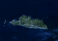
A satellite image of Shemya Island.

See also
 In Spanish: Isla Shemya para niños
