Lake Michigan–Huron facts for kids
Quick facts for kids Lake Michigan–Huron |
|
|---|---|

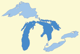
Lake Michigan–Huron lies in the center of the Great Lakes
|
|
| Location | United States, Canada |
| Group | Great Lakes |
| Coordinates | 45°48′50″N 84°45′14″W / 45.814°N 84.754°W |
| Lake type | Glacial |
| Primary inflows | St. Marys River |
| Primary outflows | St. Clair River |
| Basin countries | United States, Canada |
| Surface area | 45,300 sq mi (117,300 km2) |
| Max. depth | 922 ft (281 m) |
| Water volume | 2,029 cu mi (8,460 km3) |
| Residence time | 100 years |
| Shore length1 | 3,250 mi (5,230 km) plus 2,215 mi (3,565 km) for islands |
| Surface elevation | 577 ft (176 m) |
| Settlements | Milwaukee, Chicago, Sarnia, Owen Sound, Sheboygan, Port Huron, Traverse City |
| 1 Shore length is not a well-defined measure. | |
Lake Michigan–Huron is the name for the combined waters of Lake Michigan and Lake Huron. These two huge lakes are connected by the Straits of Mackinac. This narrow passage is about 5-mile-wide (8.0 km) and 120-foot-deep (37 m).
Even though they have different names, Lake Michigan and Lake Huron are actually one big body of water. This is because water flows freely between them. The water levels in both lakes stay almost the same. This combined lake is the largest freshwater lake in the world by surface area. However, if you count them as two separate lakes, Lake Superior is bigger than either one alone.
Contents
How the Lakes Formed
The Great Lakes, including Michigan and Huron, were formed by ice age glaciers. Over thousands of years, huge sheets of ice moved across the land. These glaciers carved out the deep basins that now hold the lakes.
Ancient Lakes and Ice Sheets
During the last ice age, the size and connections of these lake basins changed a lot. The giant Laurentian ice sheet kept moving forward and backward. This movement created and blocked different water paths. It also added huge amounts of meltwater to the system.
Many temporary lakes, called proglacial lakes, formed in different places. Sometimes, what is now Michigan–Huron was split into two or more separate lakes. At other times, it was part of one very deep lake.
The Great Lakes Evolve
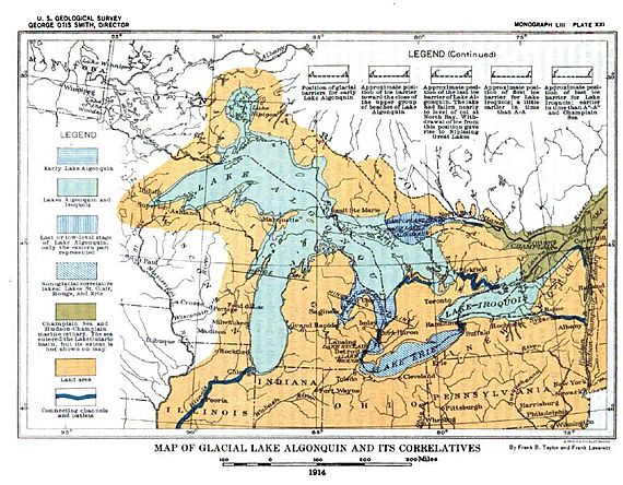
Around 11,000 years ago, the ice sheet started to melt and retreat. At this time, modern Lakes Huron, Michigan, and much of Superior were one giant lake. Geologists call this ancient lake Lake Algonquin. Ice sheets blocked Lake Algonquin to the northeast.
Before that, an older lake called Lake Chicago filled the southern part of the Lake Michigan basin. Both Lake Algonquin and Lake Chicago drained south into the Mississippi River.
About 9,500 years ago, the ice retreated more. This opened new paths for water to flow east. Then, two separate lakes formed: Lake Stanley (which became Lake Huron) and Lake Chippewa (which became Lake Michigan). Lake Chippewa was a bit higher than Lake Stanley. They were connected by the Mackinac Channel, which is now underwater. Water flowed from Lake Chippewa into Lake Stanley over Mackinac Falls.
The land slowly rose after the heavy ice melted away. This process, called post-glacial rebound, kept changing how the water drained. Eventually, all three basins (Superior, Michigan, and Huron) joined together again. This created the Nipissing Great Lakes. This arrangement lasted for over 1,000 years. It ended about 4,000 years ago when other lake outlets closed. The lakes we see today are the result of this long history.
Water Flow and Depth

The Straits of Mackinac connect Lake Michigan and Lake Huron. The Straits are 5 miles (8 km) wide and 120 feet (37 m) deep. This depth is much less than the deepest parts of the lakes themselves. Lake Huron's deepest point is 750 feet (229 m). Lake Michigan's deepest point is 923 feet (281 m).
Even though the Straits are a narrow spot, they are deep enough for water to move freely. Because of this connection, Lake Michigan and Lake Huron have the same average water level. In June 2015, their water level was 580 feet (177 m).
Water Inflow and Outflow
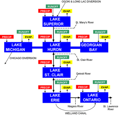
The main river flowing into this system is the St. Mary's River. This river brings water from Lake Superior. The main river flowing out is the St. Clair River, which leads to Lake Erie. Both of these rivers are in the Lake Huron basin.
Water in the Straits of Mackinac can flow in either direction. This depends on things like seiches (like sloshing waves in a bathtub) and weather conditions. Strong winds or changes in air pressure can push water one way or the other. Sometimes, huge amounts of water, more than 75,000 m3/s (2,600,000 cu ft/s), can flow in one direction for hours.
However, over a long period, the water generally flows eastward. The average flow through the Straits is about 1,500–2,000 m3/s (53,000–71,000 cu ft/s) towards the St. Clair River outlet. The amount of water flowing into the system from Lake Superior is managed. This is done by the Lake Superior Board of Control. They operate locks and canals to control the flow.
Why They Are Considered One Lake
Most people think of Lake Michigan and Lake Huron as two separate lakes. This is because they have different names and distinct basins. Also, the Straits of Mackinac create a clear bottleneck in the shoreline.
However, from a scientific view, especially in hydrology (the study of water), they are considered one body of water. This is because water moves freely between them through the Straits. Because of this connection, some experts combine their total area and volume. When treated as a single entity, Lake Michigan–Huron is the largest freshwater lake by surface area in the world.
 | Anna J. Cooper |
 | Mary McLeod Bethune |
 | Lillie Mae Bradford |


