
Kure Atoll facts for kids
|
Native name:
Hōlanikū; Mokupāpapa
|
|
|---|---|

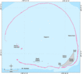
Satellite image of Kure Atoll (north is towards the upper-left corner)
|
|

Kure Atoll
Location in North Pacific

Kure Atoll
Location in Hawaiian Islands
|
|
| Geography | |
| Location | Pacific Ocean |
| Coordinates | 28°25′N 178°20′W / 28.417°N 178.333°W |
| Archipelago | Northwestern Hawaiian Islands |
| Total islands | 2 |
| Major islands | Green Island |
| Area | 0.884 km2 (0.341 sq mi) |
| Length | 5.8 mi (9.3 km) |
| Width | 4.8 mi (7.7 km) |
| Administration | |
| State | Hawaii |
| County | Honolulu County |
| Demographics | |
| Population | 0 (2012) |
| Additional information | |
| Time zone |
|


Kure Atoll is a special ring-shaped island in the Pacific Ocean. It's also known as Ocean Island. Kure Atoll is about 48 miles (77 km) west-northwest of Midway Atoll. It's part of the Northwestern Hawaiian Islands.
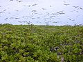
This atoll is a coral ring about 6 miles (10 km) wide. It surrounds a shallow lagoon. The biggest piece of land is called Green Island. This island is a home for hundreds of thousands of seabirds. You can still see a short, unused runway and part of an old building on the island. These are from a former United States Coast Guard station.
Kure Atoll is part of Hawaii. However, it's separated from the rest of the state by Midway, which is a different territory. Green Island is a nesting place for many seabirds. It has also seen some rare land birds like the snow bunting and Steller's sea eagle. Today, Kure Atoll is a Wildlife Bird Sanctuary. It's managed by Hawaii's Department of Land and Natural Resources. This group works with the Kure Atoll Conservancy to protect the area.
Small groups of volunteers and biologists live on Kure Atoll for parts of the year. They work to help the island's natural environment. Kure was found in the 1800s and was a common place for ships to crash. Later, it had a radio base. Now, it's mostly a nature reserve.
Kure Atoll: A Special Island Home
Island Life and Nature
.jpg)
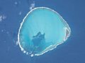
Kure Atoll is the northernmost coral atoll in the world. It has a barrier reef about 6 miles (10 km) wide. This reef surrounds a shallow lagoon and some sandy islets. The total land area is about 213 acres (86 hectares). Green Island is on the southeast side.
Many Hawaiian monk seals come to rest on Kure's beaches. The polynesian rat has also lived on the island since it was first discovered. The coral reef is shaped like a rough ring. Inside, there are two islands: Sand Island and Green Island. Green Island is about 235 acres. Sand Island is much smaller, about one acre, and has no known plants.
Plants and Habitats
Green Island has many different plants. There are groves of Beach Naupaka (Scaevola taccada). These are popular places for birds to live. Another tree found here is the heliotrope tree. There are also two groves of ironwood trees. Other common plants include Verbesina and Bermuda grass. In 2001, scientists found about 50 different plant species on Green Island.
Green Island is shaped like a triangle. It is about 1.5 miles (2.4 km) long and up to half a mile (0.8 km) wide. The highest point on the island is 25 feet (7.6 meters) high.
Amazing Animals of Kure
Many seabirds live at Kure Atoll. Some of them are:
- Black-footed Albatross
- Laysan Albatross
- Wedge-tailed Shearwater
- Red-tailed Tropic-bird
- Blue-faced Booby
- Brown Booby
- Red-footed Booby
- Great Frigate-bird
- Gray-backed Tern
- Sooty Tern
- Noddy Tern
- White-capped Noddy Tern
- White Tern
In 2002, 92 different types of algae were found in Kure Atoll's central lagoon.
Kure's Ancient Story

Kure Atoll is very old, about 30 million years old. It is the oldest island in the Hawaiian chain. Kure is slowly moving northwest because of the Pacific Plate's movement. Eventually, it will move into waters that are too cold for coral to grow. When this happens, the atoll will slowly sink and become a seamount.
In the Hawaiian language, the name Mokupāpapa means "flat island with reefs." Another Hawaiian name for Kure Atoll is Hōlanikū, which means "bringing forth heaven."
A Look Back: Kure's History
Shipwrecks and Survival
.jpg)
In the 1800s, many ships visited Kure Atoll. It was often called Ocean Island. Its English name, Kure, came from a Russian sailor who saw the atoll. It was officially named Kure Island in 1924 and Kure Atoll in 1987.
Two ships, the Gledstanes (1837) and the Parker (1842), crashed here. The crew of the Gledstanes built a new boat from their old ship's parts. Some sailed to Hawaii and sent help back. The Parker crew floated on a raft for days. They survived on birds and other wildlife. They even found a dog from the Gledstanes that had been living wild on the island! Messages were tied to seabirds to ask for help. Most of the Parker crew were rescued in April and May of 1843.
Because so many ships crashed, King Kalākaua of Hawaii sent someone to claim the island in 1886. He ordered a small house and supplies to be built for shipwrecked sailors. Sadly, the supplies were stolen, and the house fell apart. In 1867, the USS Lackawanna mapped the atoll to make better charts.
The USS Saginaw crashed in 1870. Five crew members sailed a small boat to Kauai, but only one survived the long trip. This survivor got word to authorities, and a rescue ship saved the rest of the crew in January 1871.
Kure in Modern Times

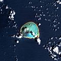
_(20319578286).jpg)
During World War II, U.S. Navy patrols checked Kure Atoll. They wanted to make sure the Japanese were not using it. A Japanese bomber crashed near Kure after being damaged in the Battle of Midway.
In the 1950s, a radar reflector was placed on the island. Scientists also used the island to study Pacific birds. In 1959, paths were cut through bushes to create space for albatrosses.
Construction for a LORAN base started in 1960 and finished in 1961. LORAN was a system that helped ships and planes find their location. A tugboat, the Port of Bandon, sank on the reef in 1961. The base had buildings, a tall radio tower, and a 4000-foot airstrip. In 1966, a Boeing 707 jet made an emergency landing at Kure Atoll.
Kure is in a major ocean current. This current brings a lot of trash from the Great Pacific garbage patch to the island. This includes fishing nets and many plastic items. This trash is dangerous for the animals, especially birds. Bird skeletons are often found with plastic inside them.
In 1998, a fishing boat called the Paradise Queen II crashed near Green Island. It spilled about 4,000 gallons of diesel fuel. This pollution harmed the wildlife and coral reef for many years. To protect these sensitive areas, the Papahānaumokuākea Marine National Monument was named a "Particularly Sensitive Sea Area" in 2008. This means ships must be careful when sailing near it.
The U.S. Coast Guard LORAN station was on Green Island from 1960 to 1992. It closed because the Global Positioning System (GPS) took its place. Kure Atoll became a state wildlife sanctuary in 1981. Since 1993, the Hawaii Department of Land and Natural Resources and volunteers have worked to restore the atoll. They clean up trash that washes ashore.
Kure Atoll Today

.jpg)
In 2002, the wreck of a 19th-century whaling ship was found at Kure Atoll. It might be the Parker, which crashed in 1842. The wreck of the USS Saginaw was found in 2003. The Gledstanes shipwreck was found in 2008.
In 2010, a sailboat wreck was found. It belonged to a sailor who disappeared in 2006. Today, crews of volunteers stay on the island for months. They watch over the island and clean up trash.
Old Radio Station and Airstrip

Kure's Green Island had a radio station from the early 1960s to 1992. It was a LORAN station, which helped ships and planes find their way. The U.S. Coast Guard ran it. This base closed because GPS, which uses satellites, became more common. The LORAN station had a 625-foot (191 m) tall radio tower. This tower was taken down after the station closed.
The Kure airport had one runway, about 3800 feet (1158 m) long. It is now closed. Airplanes like the U.S. Coast Guard HC-123B and HC-130H used to fly there. They carried mail, cargo, and people. The airstrip was also used for emergency landings.
Shipwrecks Around Kure

Kure Atoll has been the site of many shipwrecks. Some of the known wrecks include:
- 1837 Gledstanes
- 1842 Parker
- 1870 Saginaw
- 1886 Dunnottar Castle
- 1888 Ocean Pearl
- 1937 Statu Maru
- 1961 Port of Bandon
- 1976 Houei Maru
Many crews survived by living on Kure until they could be rescued.
Weather at Kure Atoll
Temperatures at Kure Atoll usually range from about 45 to 90 degrees Fahrenheit (7 to 32 degrees Celsius). There is often a wind of about 10 to 15 miles per hour (16 to 24 kph). This wind comes from the northeast.
Kure Atoll has a tropical savanna climate. This means it has high temperatures all year. Rain falls evenly throughout the year. May and June are the driest months.
| Climate data for Kure Atoll | |||||||||||||
|---|---|---|---|---|---|---|---|---|---|---|---|---|---|
| Month | Jan | Feb | Mar | Apr | May | Jun | Jul | Aug | Sep | Oct | Nov | Dec | Year |
| Record high °F (°C) | 80 (27) |
81 (27) |
81 (27) |
82 (28) |
87 (31) |
89 (32) |
92 (33) |
92 (33) |
92 (33) |
89 (32) |
88 (31) |
82 (28) |
92 (33) |
| Mean daily maximum °F (°C) | 70 (21) |
70 (21) |
71 (22) |
72 (22) |
76 (24) |
81 (27) |
83 (28) |
84 (29) |
84 (29) |
80 (27) |
76 (24) |
73 (23) |
77 (25) |
| Daily mean °F (°C) | 66 (19) |
66 (19) |
67 (19) |
69 (21) |
72 (22) |
77 (25) |
79 (26) |
80 (27) |
80 (27) |
77 (25) |
73 (23) |
69 (21) |
73 (23) |
| Mean daily minimum °F (°C) | 62 (17) |
62 (17) |
63 (17) |
64 (18) |
68 (20) |
73 (23) |
75 (24) |
75 (24) |
75 (24) |
72 (22) |
69 (21) |
65 (18) |
69 (20) |
| Record low °F (°C) | 49 (9) |
50 (10) |
51 (11) |
53 (12) |
55 (13) |
61 (16) |
63 (17) |
64 (18) |
64 (18) |
59 (15) |
55 (13) |
51 (11) |
49 (9) |
| Average precipitation inches (mm) | 5.0 (130) |
3.8 (97) |
3.0 (76) |
2.5 (64) |
2.3 (58) |
2.2 (56) |
3.3 (84) |
4.3 (110) |
3.5 (89) |
3.5 (89) |
3.8 (97) |
4.1 (100) |
41.3 (1,050) |
| Average precipitation days | 16 | 14 | 12 | 11 | 9 | 9 | 15 | 15 | 15 | 14 | 14 | 16 | 160 |
| Source: Weatherbase | |||||||||||||
Gallery
-
Bathymetric map of Kure Atoll
-
Satellite image of Kure Atoll
-
NASA astronaut image of Kure Atoll (2004/2/22)
-
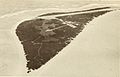
Photo of Green Island shot from the air (1968/2/27)
-

Young masked boobies (Sula dactylatra) on Green Island, Kure Atoll
-
Scaevola taccada (habit with sooty terns). Location: Kure Atoll, inland
-
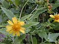
The flower of Verbesina encelioides at near camp of Kure Atoll
-
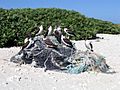
Young masked boobies (Sula dactylatra) sitting on marine debris on Green Island.


_(20159194319).jpg)


See also
 In Spanish: Atolón Kure para niños
