Van Buren, Maine facts for kids
Quick facts for kids
Van Buren, Maine
|
||
|---|---|---|

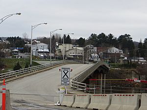
Van Buren's view from the Canada–US border
|
||
|
||
| Nickname(s):
Gateway to the St. John Valley
|
||
| Motto(s): | ||

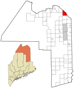
Location of Van Buren, Maine
|
||
| Country | United States | |
| State | Maine | |
| County | Aroostook | |
| Incorporated (town) | March 1881 | |
| Villages | Van Buren Keegan |
|
| Area | ||
| • Total | 34.86 sq mi (90.29 km2) | |
| • Land | 33.78 sq mi (87.49 km2) | |
| • Water | 1.08 sq mi (2.80 km2) | |
| Population
(2020)
|
||
| • Total | 2,038 | |
| • Density | 60/sq mi (23.3/km2) | |
| Time zone | UTC-5 (Eastern (EST)) | |
| • Summer (DST) | UTC-4 (EDT) | |
| ZIP code |
04785
|
|
| Area code(s) | 207 | |
Van Buren is a town in Maine, USA. It sits right on the Saint John River. This river forms part of the border between the United States and Canada. Across the river from Van Buren is the town of Saint-Leonard in New Brunswick, Canada.
In 2020, about 2,038 people lived in Van Buren. The town is named after Martin Van Buren, who was a U.S. President.
Contents
Exploring Van Buren's Location
Van Buren is located in Aroostook County, Maine. The town covers a total area of about 34.86 square miles (90.29 square kilometers). Most of this area is land, with a small part being water.
A special bridge, the Saint Leonard-Van Buren Bridge, connects Van Buren to Saint Leonard, New Brunswick. This bridge makes it easy for people to travel between the two countries.
Van Buren's Climate
Van Buren has a type of weather called a humid continental climate. This means it has big changes in temperature throughout the year. Summers are usually warm or hot, and sometimes humid. Winters are cold, and can be very cold.
| Climate data for Van Buren, Maine, (1991–2020 normals, extremes 1963–present) | |||||||||||||
|---|---|---|---|---|---|---|---|---|---|---|---|---|---|
| Month | Jan | Feb | Mar | Apr | May | Jun | Jul | Aug | Sep | Oct | Nov | Dec | Year |
| Record high °F (°C) | 52 (11) |
61 (16) |
77 (25) |
85 (29) |
94 (34) |
96 (36) |
96 (36) |
94 (34) |
92 (33) |
82 (28) |
74 (23) |
60 (16) |
96 (36) |
| Mean maximum °F (°C) | 42.4 (5.8) |
42.5 (5.8) |
51.0 (10.6) |
67.2 (19.6) |
81.0 (27.2) |
87.0 (30.6) |
88.8 (31.6) |
87.9 (31.1) |
82.2 (27.9) |
71.7 (22.1) |
59.8 (15.4) |
47.2 (8.4) |
91.2 (32.9) |
| Mean daily maximum °F (°C) | 19.1 (−7.2) |
22.6 (−5.2) |
33.0 (0.6) |
46.5 (8.1) |
61.9 (16.6) |
71.2 (21.8) |
76.3 (24.6) |
75.3 (24.1) |
66.7 (19.3) |
52.5 (11.4) |
38.8 (3.8) |
26.3 (−3.2) |
49.2 (9.6) |
| Daily mean °F (°C) | 7.4 (−13.7) |
8.9 (−12.8) |
20.9 (−6.2) |
36.4 (2.4) |
50.4 (10.2) |
59.9 (15.5) |
65.7 (18.7) |
64.1 (17.8) |
55.4 (13.0) |
42.9 (6.1) |
31.2 (−0.4) |
17.3 (−8.2) |
38.4 (3.5) |
| Mean daily minimum °F (°C) | −4.3 (−20.2) |
−4.8 (−20.4) |
8.9 (−12.8) |
26.3 (−3.2) |
38.9 (3.8) |
48.7 (9.3) |
55.2 (12.9) |
52.9 (11.6) |
44.0 (6.7) |
33.3 (0.7) |
23.7 (−4.6) |
8.2 (−13.2) |
27.6 (−2.4) |
| Mean minimum °F (°C) | −29.6 (−34.2) |
−28.9 (−33.8) |
−18.7 (−28.2) |
9.8 (−12.3) |
26.0 (−3.3) |
33.8 (1.0) |
42.6 (5.9) |
40.6 (4.8) |
29.8 (−1.2) |
19.5 (−6.9) |
3.9 (−15.6) |
−15.8 (−26.6) |
−32.9 (−36.1) |
| Record low °F (°C) | −47 (−44) |
−44 (−42) |
−37 (−38) |
−19 (−28) |
18 (−8) |
22 (−6) |
30 (−1) |
26 (−3) |
19 (−7) |
2 (−17) |
−16 (−27) |
−35 (−37) |
−47 (−44) |
| Average precipitation inches (mm) | 2.87 (73) |
2.27 (58) |
2.45 (62) |
3.06 (78) |
3.61 (92) |
3.97 (101) |
4.81 (122) |
3.48 (88) |
3.83 (97) |
4.37 (111) |
3.37 (86) |
3.38 (86) |
41.47 (1,053) |
| Average snowfall inches (cm) | 24.5 (62) |
20.0 (51) |
17.5 (44) |
5.7 (14) |
0.1 (0.25) |
0.0 (0.0) |
0.0 (0.0) |
0.0 (0.0) |
0.0 (0.0) |
0.8 (2.0) |
7.4 (19) |
20.7 (53) |
96.7 (246) |
| Average precipitation days (≥ 0.01 in) | 10.4 | 9.3 | 10.5 | 11.2 | 13.5 | 12.8 | 14.4 | 12.5 | 11.4 | 13.2 | 12.2 | 12.0 | 143.4 |
| Average snowy days (≥ 0.1 in) | 8.1 | 7.6 | 6.1 | 2.4 | 0.1 | 0.0 | 0.0 | 0.0 | 0.0 | 0.4 | 3.3 | 7.6 | 35.6 |
| Average relative humidity (%) | 92 | 93 | 93 | 87 | 76 | 77 | 78 | 80 | 81 | 82 | 82 | 90 | 84 |
| Mean daily sunshine hours | 2.4 | 2.1 | 3.0 | 5.2 | 7.4 | 8.2 | 9.2 | 9.3 | 7.1 | 5.4 | 3.9 | 2.9 | 5.5 |
| Mean daily daylight hours | 9.0 | 10.3 | 12.0 | 13.7 | 15.1 | 15.9 | 15.5 | 14.2 | 12.5 | 10.8 | 9.4 | 8.6 | 12.3 |
| Average ultraviolet index | 1 | 1 | 1 | 2 | 4 | 5 | 5 | 4 | 3 | 2 | 1 | 1 | 3 |
| Source 1: NOAA | |||||||||||||
| Source 2: Weather Atlas (UV and humidity) | |||||||||||||
Schools in Van Buren
Van Buren is part of the Maine School Administrative District No. 24. This school system includes two main schools:
- Van Buren District Elementary School
- Van Buren District Secondary School
Van Buren's Population
| Historical population | |||
|---|---|---|---|
| Census | Pop. | %± | |
| 1850 | 1,050 | — | |
| 1860 | 616 | −41.3% | |
| 1870 | 922 | 49.7% | |
| 1880 | 1,110 | 20.4% | |
| 1890 | 1,168 | 5.2% | |
| 1900 | 1,878 | 60.8% | |
| 1910 | 3,065 | 63.2% | |
| 1920 | 4,594 | 49.9% | |
| 1930 | 4,721 | 2.8% | |
| 1940 | 5,380 | 14.0% | |
| 1950 | 5,094 | −5.3% | |
| 1960 | 4,679 | −8.1% | |
| 1970 | 3,971 | −15.1% | |
| 1980 | 3,557 | −10.4% | |
| 1990 | 3,045 | −14.4% | |
| 2000 | 2,631 | −13.6% | |
| 2010 | 2,171 | −17.5% | |
| 2020 | 2,038 | −6.1% | |
| U.S. Decennial Census | |||
Many people in Van Buren speak French. About 76.6% of the residents speak French regularly. Because of this, Van Buren has strong connections with Québec and New Brunswick, which are French-speaking areas in Canada.
Population Details (2010)
According to the census from 2010, there were 2,171 people living in Van Buren. These people lived in 1,027 households, and 601 of these were families.
Most of the people living in Van Buren (96.9%) were White. A small number of residents were African American, Native American, or Asian. Some people identified as being from two or more races.
The average age of people in Van Buren in 2010 was 51.5 years old.
- About 15.9% of residents were under 18 years old.
- About 24.7% of residents were 65 years or older.
- The town had slightly more females (51.5%) than males (48.5%).
See also
 In Spanish: Van Buren (Maine) para niños
 | Percy Lavon Julian |
 | Katherine Johnson |
 | George Washington Carver |
 | Annie Easley |


